Governing the Third Dimension: Institutional Architecture, Cross-Jurisdictional Harmonization, and…
Abstract The transition of the Low-Altitude Economy (LAE) from experimental prototypes to pervasive urban mobility networks is constrained…
Governing the Third Dimension: Institutional Architecture, Cross-Jurisdictional Harmonization, and Risk Allocation in the Greater Bay Area’s Low-Altitude Economy
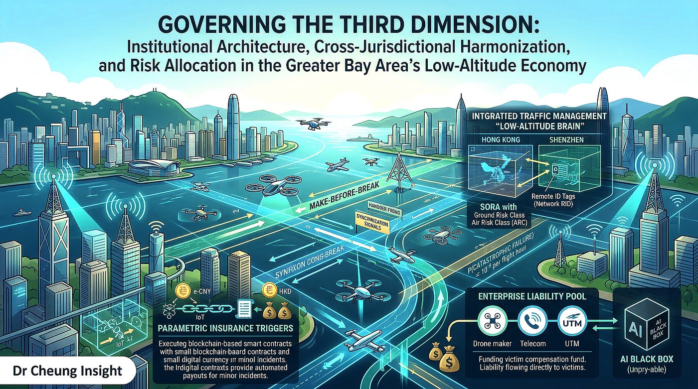
Abstract The transition of the Low-Altitude Economy (LAE) from experimental prototypes to pervasive urban mobility networks is constrained less by physics than by institutional architecture. This article examines the regulatory frameworks of the Greater Bay Area (GBA), contrasting Hong Kong’s empirical, common-law approach with Shenzhen’s aggressive “iterative certification” model. By analyzing the application of the Specific Operations Risk Assessment (SORA) and the shift from prescriptive to performance-based regulation, the study illustrates how safety is mathematically codified. Furthermore, it explores the technical and electromagnetic prerequisites for regional integration, specifically the role of 5G-Advanced (5G-A) and unified Remote ID protocols in enabling seamless cross-border operations. Finally, the article deconstructs the legal and actuarial crisis precipitated by autonomous “black box” systems, proposing enterprise liability and blockchain-based parametric insurance as the necessary financial bedrock for scaling Advanced Air Mobility (AAM). Keywords: Low-Altitude Economy (LAE), Regulatory Sandbox, Advanced Air Mobility (AAM), SORA, 5G-Advanced, eVTOL Liability, Greater Bay Area (GBA), Unmanned Traffic Management (UTM). Introduction The emergence of the Low-Altitude Economy (LAE) represents a paradigm shift in urban morphology. For the first time, the “third dimension” of the city is being colonized not by rare, human-piloted helicopters, but by dense networks of autonomous, electric vertical takeoff and landing (eVTOL) vehicles. However, the legacy of aviation regulation — built on forensic analysis of 20th-century catastrophes — is ill-equipped for the “fail-fast” velocity of the technology sector. In the Greater Bay Area (GBA), this tension is being resolved through the construction of “Regulatory Sandboxes.” These geographically circumscribed environments allow for the iterative deployment of uncertified technologies under rigorous supervision. The challenge is twofold: first, bridging the institutional gap between the common-law caution of Hong Kong and the state-directed scaling of Shenzhen; and second, establishing a harmonized digital and legal substrate — encompassing 5G-Advanced connectivity, unified data ontologies, and novel liability models — that allows a fragmented megaregion to operate as a single, contiguous airspace. A. Institutional Architecture of the LAE Sandbox The transition of the Low-Altitude Economy (LAE) from isolated technological prototypes to a pervasive, integrated urban mobility network is fundamentally constrained not by aerodynamics or battery chemistry, but by institutional architecture. Aviation regulation is historically reactive, built upon decades of forensic analysis of human-piloted, combustion-engine catastrophes. The emergence of autonomous, distributed electric propulsion (DEP) vehicles operating in hyper-dense urban canyons renders these legacy frameworks obsolete. To prevent regulatory stagnation from stifling technological velocity, authorities within the Greater Bay Area (GBA) have championed the concept of the “Regulatory Sandbox.” A regulatory sandbox is a legally circumscribed, geographically defined testing environment that permits the iterative deployment of uncertified or pre-certified technologies under close regulatory supervision. It is an institutional compromise between the “fail-fast” ethos of the technology sector and the zero-tolerance safety mandates of civil aviation authorities. This section provides a comprehensive examination of the institutional architecture governing the GBA’s LAE sandboxes. It first contrasts the empirical pilot frameworks established by Hong Kong and Shenzhen, highlighting the divergence between common-law caution and state-directed iterative scaling. Subsequently, it conducts a rigorous theoretical analysis of the underlying risk-based regulatory methodologies, specifically evaluating the application of the Specific Operations Risk Assessment (SORA) and the broader paradigm shift from prescriptive to performance-based regulation.
- Examination of Pilot Frameworks The deployment of Advanced Air Mobility (AAM) within the GBA cannot be executed via a monolithic regulatory decree. The physical, demographic, and legal disparities across the Pearl River Estuary require highly tailored, localized pilot frameworks. These frameworks act as the empirical data-gathering mechanisms for future legislation. By examining the structural rollout of pilot projects in Hong Kong and the iterative certification models in Shenzhen, we can map the exact institutional pathways through which theoretical aeromobility becomes operational reality. 1.1 Analysis of the 2025 Hong Kong Low-Altitude Pilot Project Operating under a Common Law framework heavily influenced by international aviation standards (ICAO, EASA, FAA), the Hong Kong Civil Aviation Department (HK-CAD) historically maintains one of the most rigorous and conservative safety postures globally. However, recognizing the immense economic potential of the LAE — projected by the Civil Aviation Administration of China (CAAC) to reach 1.5 trillion yuan domestically by 2025 (CAAC, 2025, p. 2) — the Hong Kong Special Administrative Region (SAR) Government initiated a paradigm shift. Following the 2024 Policy Address by Chief Executive John Lee, which established the Working Group on Developing Low-altitude Economy, Hong Kong formally launched its LAE Regulatory Sandbox in March 2025 (HK SAR Government, 2025a, p. 1). The architectural philosophy of the Hong Kong sandbox is deeply empirical and deliberately phased. The Working Group received 72 applications from industry stakeholders, ultimately selecting a first batch of 38 pilot projects that commenced trial operations in April 2025 (HK SAR Government, 2025b, p. 1). The analytical value of the 2025 Hong Kong Pilot Project lies in its specific focus areas, which deliberately avoid immediate passenger transport in favor of lower-risk, high-utility civic applications. The selected projects are categorized into four primary domains: emergency and rescue, logistics and distribution, inspection and safety maintenance, and low-altitude infrastructure surveillance. For example, the Environmental Protection Department utilizes the sandbox to transport air quality sensors to remote islands, while the Agriculture, Fisheries and Conservation Department utilizes drones for maritime patrol (Esri China, 2025, p. 2). A critical component of this sandbox is the testing of Beyond Visual Line of Sight (BVLOS) capabilities utilizing advanced Geographic Information Systems (GIS). Because Hong Kong’s topography features abrupt transitions between dense skyscraper canyons and mountainous terrain, maintaining continuous command-and-control (C2) links is highly challenging. Firms like Esri China are utilizing the sandbox to validate 3D spatial data systems and algorithmic routing that dynamically avoids signal shadow-zones. Institutionally, the sandbox serves as a legislative incubator. The data collected from these 38 projects is explicitly earmarked to inform amendments to the Air Navigation (Hong Kong) Order 1995 and the Small Unmanned Aircraft Order (Cap. 448G). Furthermore, the government has stated that the data will form the empirical basis for drafting entirely new, dedicated legislation for unconventional aircraft weighing over 150 kilograms (HK SAR Government, 2025a, p. 2). Table 1. Typological Analysis of the 2025 Hong Kong LAE Regulatory Sandbox (First Batch)
Application Category Selected Project Examples Primary Institutional Objective Key Technical/Regulatory Metric Tested Civic Governance & Inspection Power grid inspection (EagleEye AI); CAS camp surveys. Validate the safety of small UAS operations in populated areas. AI-driven defect detection reliability; visual line of sight (VLOS) to BVLOS transition safety. Middle-Mile Logistics Transporting environmental sensors to remote islands. Establish economic viability for government procurement of LAE services. BVLOS C2 link stability over maritime environments; payload integrity. Infrastructure Integration 3D GIS mapping for dynamic route deconfliction. Build the foundational data layer for a future Hong Kong UTM system. Algorithmic accuracy of spatial geofencing in high-density high-rise zones. Cross-Boundary Frameworks Simulated data handover trials (planned Q4 2025). Prepare for SAR-to-Mainland seamless operations. Cryptographic security of remote ID and telemetric data sovereignty.
Source: Synthesized from the Hong Kong Digital Policy Office (2025) and Transport and Logistics Bureau pilot announcements. Table 1 demonstrates that the Hong Kong sandbox is not primarily focused on commercial monetization, but rather on civic utility and institutional capacity building. By utilizing government departments as the primary initial clients, the HK-CAD can closely monitor the operational data, building the statistical confidence required to eventually underwrite complex commercial passenger flights. 1.2 Success Metrics for “Iterative Certification” in Shenzhen In stark contrast to Hong Kong’s meticulous, phased approach, the municipality of Shenzhen — backed by the CAAC — operates an aggressive, scale-driven sandbox designed to maximize the “velocity of innovation.” Designated as a Comprehensive National LAE Pilot Zone, Shenzhen’s institutional architecture relies on the concept of “Iterative Certification.” Traditional aviation certification (e.g., FAA Part 23 for normal category airplanes) is a rigid, ex-ante linear process. The manufacturer finalizes a design, submits it to the regulator, endures years of static testing, and receives a Type Certificate (TC) only when the design is entirely immutable. This process is fatal to AAM startups, whose software and battery chemistries evolve on a month-to-month basis. Iterative certification, as pioneered in the Shenzhen sandbox, flips this paradigm. It permits manufacturers to deploy early-stage iterations of their vehicles into controlled public airspace to gather massive amounts of real-world operational data. The certification is not granted at the end of the process; rather, provisional operational authorizations are granted continuously, expanding in scope as the algorithmic safety is empirically proven through millions of accumulated flight hours. The ultimate manifestation of this model was the CAAC’s issuance of the Type Certificate, Production Certificate, and Standard Airworthiness Certificate to the EHang EH216-S passenger eVTOL. This represented a global watershed event, as it was the first time a fully autonomous, pilotless passenger vehicle was legally certified for commercial operation. However, defining the success of the Shenzhen sandbox requires rigorous, quantifiable metrics beyond merely counting the number of certificates issued. The institutional success of iterative certification is evaluated through three primary vectors: Systemic Incident Tolerance Rate (SITR): In an iterative sandbox, incidents (e.g., a cargo drone executing an emergency landing due to a motor failure) are not viewed as institutional failures, but as vital data points. The SITR measures the ability of the Unmanned Traffic Management (UTM) system (the “Low-Altitude Brain”) to isolate the failure and prevent a cascading safety event. Success is defined by an asymptotic approach to zero for third-party casualties, even if the absolute number of hardware failures remains temporarily elevated during the early phases of the sandbox. Cumulative Algorithmic Learning Hours: Machine learning algorithms governing BVLOS deconfliction require vast datasets to handle “edge cases” (e.g., sudden microbursts, flocks of birds). The success of the Shenzhen model is directly correlated to flight volume. By subsidizing operations — leading to Shenzhen’s plan to execute millions of cargo flights and build over 600 vertiports by 2025 (Xinhua, 2024, p. 1) — the sandbox generates the specific data required to train the AI to a standard that mathematically exceeds human piloting capabilities. Time-to-Market Compression: The economic metric of success is the reduction in the certification timeline. While Western eVTOL firms remain mired in decade-long FAA certification pathways, the Shenzhen iterative model allowed domestic firms to transition from prototype to commercial deployment in less than five years, establishing a massive first-mover advantage in global LAE exports. The pilot frameworks of the GBA represent a dual-engine regulatory laboratory. The Hong Kong 2025 Pilot Project provides the meticulous, common-law scrutinized, evidence-based data gathering necessary for international legitimacy and integration into hyper-dense vertical cities. Conversely, Shenzhen’s Iterative Certification model provides the massive scale, rapid prototyping, and algorithmic training grounds necessary to drive the technology forward. Together, these frameworks establish a comprehensive institutional architecture capable of transitioning the LAE from experimental sandboxes to a permanent, region-wide economic utility. 2. Risk-Based Regulatory Methodologies The physical deployment of vehicles within sandboxes must be governed by an underlying philosophy of safety assessment. The LAE fundamentally challenges legacy aviation because the morphological diversity of the vehicles (multirotors, lift+cruise, vectored thrust) and the variation in their missions (delivering blood vs. delivering pizzas) make uniform, prescriptive rules impossible to enforce. To resolve this, the institutional architecture of the GBA has embraced Risk-Based Regulatory Methodologies. This section deeply analyzes the Specific Operations Risk Assessment (SORA) methodology — the global standard for UAS risk calculation — and examines the broader, vital paradigm shift from prescriptive to performance-based regulation. 2.1 SORA (Specific Operations Risk Assessment) application in the GBA Developed by the Joint Authorities for Rulemaking on Unmanned Systems (JARUS) and widely adopted by the European Union Aviation Safety Agency (EASA) and the HK-CAD, the Specific Operations Risk Assessment (SORA) provides a rigorous, standardized, mathematical framework for evaluating the safety of any given drone operation. SORA fundamentally shifts the regulatory focus from the vehicle itself to the operation being conducted (JARUS, 2024, p. 2). The SORA methodology is a multi-step process that systematically quantifies the risk of an operation and mandates corresponding mitigations. It relies on the calculation of two primary risk vectors: the Ground Risk Class (GRC) and the Air Risk Class (ARC).
- Ground Risk Class (GRC): The GRC assesses the probability and severity of a drone fatally impacting a person on the ground. The intrinsic GRC is determined by two factors: the characteristic dimension/kinetic energy of the drone, and the operational scenario (e.g., flying over a controlled area vs. flying over a densely populated urban center). The severity of a ground impact is a direct function of the vehicle’s kinetic energy (KE) upon impact. Under the ballistic descent model assumed in SORA calculations (where a total loss of power results in an unmitigated fall), the kinetic energy is calculated as: KE = 1/2 m v_impact² Where m is the mass of the drone and v_impact is the terminal velocity. To reduce the intrinsic GRC, an operator must apply strategic mitigations. A primary hardware mitigation is the integration of a ballistic recovery system (parachute). If a parachute successfully deploys, it drastically reduces v_impact, lowering the KE below the human lethality threshold (often cited as roughly 80 Joules), thereby mathematically justifying a reduction in the final GRC score (EASA, 2019, p. 14).
- Air Risk Class (ARC): The ARC evaluates the probability of a mid-air collision with manned aircraft. It is categorized from ARC-a (atypical airspace, extremely low risk) to ARC-d (controlled airspace with high density of manned aviation). In the GBA, particularly near major hubs like Hong Kong International Airport (HKIA) or Shenzhen Bao’an, any LAE operation inherently triggers a high initial ARC. To reduce the ARC, operators must implement Tactical Mitigations Performance Requirements (TMPR), the most critical being advanced Detect and Avoid (DAA) hardware, utilizing radar, LiDAR, and electro-optical sensors to autonomously alter the flight path when an intruder aircraft is detected.
- Specific Assurance and Integrity Level (SAIL): The final GRC and the residual ARC are synthesized using a predefined matrix to determine the Specific Assurance and Integrity Level (SAIL) of the operation, ranging from SAIL I (lowest risk) to SAIL VI (highest risk). The SAIL level dictates the Operational Safety Objectives (OSOs) that the operator must satisfy. SORA outlines 24 distinct OSOs, covering everything from the manufacturing quality of the drone to the training of the remote pilot. Crucially, SORA introduces the concept of “Robustness.” An OSO must be met with a Low, Medium, or High level of robustness, which is a combination of Integrity (the safety gain provided) and Assurance (the method of proof). For example, if a Meituan delivery drone in Shenzhen operates over a highly populated area, yielding a SAIL IV rating, OSO #05 (UAS designed and produced utilizing recognized standards) must be met with a High level of robustness. This means the manufacturer cannot simply self-declare the drone safe; they must provide exhaustive, third-party validated engineering data. Table 2. Application of SORA Methodology in GBA Urban Contexts
SORA Parameter Theoretical Definition GBA Operational Context / Challenge Applied Mitigation Strategy Ground Risk Class (GRC) Risk of fatal impact on third parties on the ground. Hyper-dense populations in Shenzhen/HK make avoiding people impossible; high intrinsic GRC. Mandated M2 mitigations (e.g., verified ballistic parachutes) and M1 mitigations (algorithmic routing over rivers/parks). Air Risk Class (ARC) Probability of mid-air collision with manned aircraft. Complex shared airspace heavily utilized by commercial jets and legacy helicopters. Geo-fencing via UTM and mandate for active Electronic Conspicuity (Network Remote ID over 5G-A). SAIL Determination The aggregate risk profile dictating the required robustness of safety objectives. Most commercial urban operations default to SAIL IV, V, or VI, demanding aerospace-grade certification. Utilizing the GBA Sandbox to gather the empirical data necessary to prove “High Assurance” for complex OSOs.
Source: Synthesized from JARUS SORA Guidelines v2.5 and EASA AMC to Article 11 to Regulation (EU) 2019/947. Table 2 dissects how a globally standardized theoretical risk model is practically applied in one of the most challenging airspaces on Earth. It demonstrates that the density of the GBA forces operators into high SAIL categories, meaning that purely software-based solutions are insufficient; operators must deploy robust, physically verified hardware mitigations (like parachutes and DAA radar) to legally operate under SORA. 2.2 Moving from “Prescriptive” to “Performance-Based” regulation The adoption of SORA is indicative of a much larger institutional evolution within the GBA’s aviation authorities: the transition from prescriptive to performance-based regulation. This shift is the absolute prerequisite for the survival and scaling of the Low-Altitude Economy. Historically, aviation regulation is Prescriptive. The regulator dictates the exact design specifications, materials, and engineering methods required to achieve safety. For example, a prescriptive regulation for a commercial airliner might mandate: “The aircraft must be equipped with two independent hydraulic systems powered by separate turbofan engines.” This approach works well for mature, homogenous technologies. However, if a regulator applies this rule to a hexacopter eVTOL that uses distributed electric motors and no hydraulic fluids whatsoever, the regulation becomes nonsensical. Prescriptive rules inherently ban innovation by mandating adherence to legacy engineering solutions. To foster the LAE, the CAAC and HK-CAD are adopting Performance-Based regulation. In this paradigm, the regulator defines the required safety outcome rather than the specific technological means to achieve it. Instead of mandating two hydraulic systems, a performance-based rule states: “The aircraft must demonstrate that a catastrophic failure resulting in the loss of the vehicle and fatalities is extremely improbable.” In aerospace engineering, “extremely improbable” is rigorously defined by a quantitative probability threshold. For passenger-carrying commercial aircraft, this is universally accepted as a failure rate of less than or equal to 10^-9 per flight hour. This mathematical threshold — one catastrophic failure per one billion flight hours — is the foundational equation of performance-based certification: P(Catastrophic Failure) ≤ 10^-9 / flight hour Under a performance-based regime, it is the burden of the eVTOL manufacturer (e.g., AutoFlight or EHang) to utilize Fault Tree Analysis (FTA) and Failure Mode and Effects Analysis (FMEA) to mathematically prove to the regulator that their unique combination of distributed electric motors, redundant flight control computers, and solid-state batteries meets or exceeds this 10^-9 threshold. This paradigm shift is profoundly visible in the CAAC’s approach to certifying the EHang EH216-S. Because the vehicle lacks traditional pilot controls, prescriptive rules requiring physical stick-and-rudder linkages were discarded. Instead, the CAAC established Special Conditions (SC) tailored specifically to the vehicle, focusing entirely on the performance of its redundant C2 links and autonomous failsafe algorithms. Table 3. Comparison of Regulatory Paradigms in Aviation Governance
Regulatory Dimension Prescriptive Paradigm Performance-Based Paradigm Impact on the Low-Altitude Economy Focus of Regulation Technical specifications (“How to build it”). Safety outcomes (“What must be achieved”). Allows radical morphological diversity (e.g., multi-rotors, autonomous gliders). Adaptability Rigid; requires years of legislative action to update. Highly flexible; accommodates new technologies instantly if they meet the safety threshold. Prevents regulatory bottlenecks; matches the “velocity of innovation” of the tech sector. Burden of Proof Regulator must understand and approve every nut and bolt. Manufacturer must provide mathematical/empirical proof of system safety (e.g., $10^{-9}$ probability). Shifts the heavy R&D and data-collection burden onto the private sector via the Sandbox.
Source: Synthesized from standard aviation regulatory theory and the CAAC’s specialized conditions for UAV certification. Table 3 highlights the philosophical rupture in aviation law required by the LAE. The transition to performance-based regulation is what makes the sandbox possible. By freeing engineers from the dogma of 20th-century aircraft design, regulators in the GBA empower the private sector to solve complex urban mobility challenges utilizing the most efficient, novel technologies available, provided they can mathematically guarantee the safety of the citizens below. The deployment of the Low-Altitude Economy is fundamentally governed by the sophisticated application of risk-based methodologies. By adopting the SORA framework, authorities can systematically quantify and mitigate the complex ground and air risks inherent in dense urban operations. Furthermore, the sweeping institutional shift from prescriptive, hardware-dictated rules to agile, performance-based regulations allows the GBA to safely certify radically novel technologies. This methodological evolution ensures that the regulatory architecture acts as a highly calibrated filter, prioritizing public safety without strangling the technological velocity that defines the region. Conclusion The institutional architecture of the Low-Altitude Economy Sandbox is the critical bridge spanning the chasm between experimental engineering and daily civic utility. The Greater Bay Area has constructed a formidable dual-engine regulatory environment. Through Hong Kong’s meticulous 2025 Pilot Projects, the region is securing the common-law validation and cross-boundary data necessary for global trust. Simultaneously, through Shenzhen’s aggressive Iterative Certification models, the region is generating the massive operational scale required to perfect autonomous algorithms. Underpinning this entire physical deployment is a profound philosophical shift: the adoption of SORA and performance-based regulation. By demanding rigorous mathematical proof of safety rather than blind adherence to legacy designs, the GBA’s institutional architecture has successfully transformed the sky from an impenetrable regulatory fortress into a dynamic, manageable, and highly lucrative economic frontier. B. Harmonization of Airspace Regulations The transition from localized, municipal pilot projects to a fully integrated, regional Low-Altitude Economy (LAE) hinges entirely upon the harmonization of airspace regulations. While regulatory sandboxes, such as those in Shenzhen and Hong Kong, provide the necessary incubators for technological maturation, they inherently produce fragmented, localized rulesets. If an electric vertical takeoff and landing (eVTOL) vehicle must physically land, undergo a software reconfiguration, and change its telemetric broadcasting standards merely to cross the invisible boundary over the Pearl River Estuary, the fundamental economic utility of Advanced Air Mobility (AAM) — high-speed, frictionless transit — is entirely negated. Therefore, harmonization is not merely an administrative convenience; it is the structural prerequisite for network scalability. The theoretical framework underpinning this harmonization draws heavily from institutional economics and the governance of complex socio-technical systems. As megaregions integrate, the transaction costs associated with navigating disparate legal and technical regimes become prohibitive (North, 1990, p. 27). To minimize these costs, authorities must construct boundary-spanning mechanisms that synchronize both the digital architecture and the institutional oversight of the airspace. This section comprehensively examines these mechanisms. It first delves into the technical and institutional interoperability required to bridge the Greater Bay Area’s (GBA) legal silos, focusing on Remote Identification (Remote ID) standards and the critical role of joint-governance alliances. Subsequently, it rigorously analyzes the electromagnetic substrate of this harmonization: the integration of 5G-Advanced (5G-A) and emerging 6G telecommunications networks to ensure seamless, deterministic handover of command and control links across sovereign boundaries.
- Interoperability Mechanisms Interoperability in the context of the LAE is defined as the ability of distinct Unmanned Aircraft System Traffic Management (UTM) networks, operated by different sovereign or municipal entities, to seamlessly exchange, interpret, and act upon critical flight data in real-time. Without interoperability, the GBA remains an archipelago of isolated digital airspaces. Achieving this seamlessness requires a two-pronged approach: the strict standardization of technical data protocols at the machine level, and the establishment of robust, cross-jurisdictional governance committees at the institutional level. 1.1 Technical Standards for Cross-Border Remote ID and Flight Telemetry The foundational pillar of technical interoperability is the standardization of Remote Identification (Remote ID) and flight telemetry. In legacy aviation, interoperability is achieved via transponders broadcasting Automatic Dependent Surveillance-Broadcast (ADS-B) signals. However, applying ADS-B to the LAE is fundamentally unviable. The 1090 MHz spectrum utilized by ADS-B lacks the bandwidth to support tens of thousands of simultaneous urban drone flights, leading to signal saturation, packet collision, and the “deafening” of legacy air traffic control receivers (Strohmeier et al., 2015, p. 6). Consequently, the LAE relies on Network Remote ID (Net-RID) and Broadcast Remote ID (B-RID), which utilize commercial cellular networks and localized Wi-Fi/Bluetooth protocols, respectively. For a drone traversing the GBA, crossing from the jurisdiction of the Civil Aviation Administration of China (CAAC) into the Hong Kong Civil Aviation Department (HK-CAD), its Net-RID must be universally legible to both UTM systems. The global baseline for this interoperability is derived from standards such as ASTM F3411–22a (Standard Specification for Remote ID and Tracking). However, the GBA faces unique challenges regarding data payloads. A harmonized telemetry standard must define the exact syntax and semantic structure of the data packets. A standardized JSON (JavaScript Object Notation) payload for a cross-border flight must transmit, at minimum: the UAS unique identifier (often utilizing a cryptographic hash to protect commercial privacy), dynamic state vectors (latitude, longitude, geodetic altitude, velocity, and timestamp), and the operational status (e.g., nominal flight, emergency, or C2 link degradation). To quantify the necessity of standardized telemetry, we must examine the mathematics of latency in conflict resolution. If an eVTOL is traveling at a cruise speed of 130 km/h (approximately 36 m/s), a telemetric delay or a translation error between two disparate UTM databases can be catastrophic. The total latency (T_total) of a telemetric packet cross-border can be modeled as: T_total = T_prop + T_trans + T_proc + T_translation Where T_prop is propagation delay, T_trans is transmission delay, T_proc is the processing delay at the network edge, and T_translation is the time required to translate the data format from one UTM standard to another. In an unharmonized system, Ttranslation becomes the dominant variable. If the Shenzhen UTM utilizes a proprietary binary protocol and the Hong Kong UTM requires a RESTful API polling an XML database, the translation overhead can easily exceed 500 milliseconds. In that half-second, the eVTOL has traveled 18 meters — a distance that severely compromises the effectiveness of automated Detect and Avoid (DAA) algorithms operating in dense urban airspace. Harmonization eradicates $T{translation}$ by enforcing a unified data ontology. A recent empirical demonstration of this necessity occurred during the 2024 cross-bay eVTOL test flights. To ensure safety, operators had to utilize middleware to bridge the CAAC’s experimental traffic management feeds with local maritime and aviation radar APIs. A permanently harmonized standard eliminates this middleware, allowing the CAAC’s “Low-Altitude Brain” to seamlessly federate its data with Hong Kong’s emerging UTM framework via standardized, ultra-low-latency Application Programming Interfaces (APIs). Table 4. Comparative Analysis of Telemetry and Remote ID Harmonization Standards
Technical Parameter Legacy Aviation (Un-harmonized LAE equivalent) Harmonized GBA LAE Standard (Proposed) Impact on Cross-Border Operations Identification Protocol ADS-B (1090 MHz) / Proprietary OEM signals. ASTM F3411–22a (Network Remote ID) via 5G-A. Prevents spectrum saturation; ensures all cross-border traffic is authenticated via cellular networks. Data Payload Structure Disparate formats (Binary, XML, localized JSON). Unified, lightweight JSON ontology (e.g., standardized GBA-UTM API). Eliminates translation latency ($T_{translation}$); allows instantaneous multi-jurisdictional deconfliction. Security & Privacy Unencrypted, plaintext broadcasts. Public Key Infrastructure (PKI) with dynamic, rotating cryptographic hashes. Protects commercial logistics data while satisfying national security and data sovereignty mandates. Update Frequency 1 Hz (1 update per second). Dynamic (Up to 10 Hz for urban canyons, 1 Hz for open estuary cruise). Provides the granularity necessary for autonomous algorithms to prevent collisions in high-density zones.
Source: Synthesized from global UTM architecture whitepapers (e.g., Global UTM Association) and CAAC low-altitude technical guidelines (2024). Table 4 breaks down the granular technical requirements of harmonization. It illustrates that simply “sharing data” is insufficient; the data must be cryptographically secure, uniformly structured, and transmitted with zero translation friction. Moving from legacy ADS-B to a harmonized, PKI-secured Network Remote ID is the foundational engineering step required to treat the fragmented GBA airspace as a single, contiguous digital medium. 1.2 Joint-Governance Committees: The Role of the GBA Low-Altitude Economy Alliance Technical standards cannot enforce themselves; they require the continuous oversight, dispute resolution, and evolutionary guidance of formalized human institutions. Regulatory harmonization in a region defined by “One Country, Two Systems” demands the creation of boundary-spanning organizations capable of navigating deep-seated legal and political asymmetries. The primary vehicle for this institutional interoperability is the GBA Low-Altitude Economy Alliance. Founded as a consortium of municipal governments, civil aviation authorities, leading technology firms (such as DJI, EHang, and SF Express), and prominent academic institutions (like the Hong Kong University of Science and Technology), the Alliance functions as a joint-governance committee. In institutional theory, such alliances are vital for overcoming the “prisoner’s dilemma” inherent in regional competition. Without a coordinating body, municipalities might engage in a regulatory race to the bottom to attract AAM investment, compromising safety, or conversely, erect protectionist digital borders that stifle regional utility. The role of the GBA Low-Altitude Economy Alliance is multidimensional. Firstly, it serves as the central clearinghouse for standards development. Drawing parallels to the European Union’s U-space regulatory framework — which required the harmonization of 27 distinct national aviation authorities (EASA, 2021, p. 8) — the Alliance drafts the “GBA Protocol.” This protocol aims to unify Pilot Licensing (transitioning from human-in-the-loop to remote-supervisor certifications) and Airframe Certification standards. By agreeing upon a mutual recognition framework, a cargo eVTOL certified under the CAAC’s sandbox in Shenzhen can be fast-tracked for operational approval by the HK-CAD, drastically reducing redundant bureaucratic friction. Secondly, the Alliance acts as a geopolitical buffer regarding data sovereignty. As analyzed previously, the transmission of high-resolution spatial data across the GBA borders triggers severe national security and privacy legal conflicts. The joint-governance committee is tasked with defining the precise parameters of “Edge-Computing Sanitization” — agreeing upon exactly which data vectors are legally permissible to cross the border and establishing the shared Public Key Infrastructure (PKI) root authorities that both mainland and SAR entities trust to authenticate flights. Table 5. Stakeholder Matrix and Functions of the GBA Low-Altitude Economy Alliance
Stakeholder Group Representation Examples Primary Contribution to Harmonization Institutional Objective within the Alliance Aviation Regulators CAAC (Mainland), HK-CAD, AACM (Macao). Mutual recognition of Type Certificates; alignment of SORA risk methodologies. Ensure absolute safety compliance while avoiding redundant, multi-jurisdictional certification delays. Municipal Governments Shenzhen Transport Bureau, HK Transport and Logistics Bureau. Harmonization of urban planning, noise zoning, and physical vertiport standards. Ensure local public acceptance; integrate 3D sky-corridors into regional terrestrial master plans. Industry Core (Hardware/UTM) DJI, EHang, AutoFlight, Huawei, China Mobile. Proposing viable technical specifications; providing empirical sandbox data. Prevent regulations from outpacing technical reality; establish dominance of domestic AAM standards globally. Academia & Actuarial HKUST, Hong Kong Insurance Authority. Advanced aerodynamic modeling; establishing cross-border liability insurance pools. Provide independent verification of safety algorithms; solve the common-law vs. civil-law liability gap.
Source: Synthesized from the organizational structure of regional economic development alliances and GBA policy directives (2024–2025). Table 5 maps the complex institutional ecosystem required to govern the airspace. The Alliance is not a monolithic regulator, but a collaborative forum. By forcing regulators, hardware manufacturers, and urban planners to jointly draft the harmonization protocols, the Alliance ensures that the resulting regulations are technically feasible, economically viable, and legally robust across all three GBA jurisdictions. Interoperability is the invisible glue of the Low-Altitude Economy. Without the rigorous harmonization of technical standards — specifically transitioning to a unified, lightweight, and cryptographically secure Network Remote ID protocol — the region’s UTM systems cannot mathematically guarantee safe deconfliction across borders. Furthermore, these technical protocols are entirely reliant on the institutional architecture of joint-governance committees. The GBA Low-Altitude Economy Alliance serves as the critical boundary-spanning organization, negotiating the legal and data sovereignty compromises necessary to fuse three distinct jurisdictions into a single, cohesive, three-dimensional transit network. 2. Spectrum Management and Communications If harmonized data protocols are the language of the LAE, the electromagnetic spectrum is the physical air carrying the sound. The absolute reliance on continuous, high-bandwidth, ultra-low-latency telemetry fundamentally shifts aviation safety from aerodynamics to telecommunications. A temporary loss of engine power in a traditional helicopter is an emergency; a temporary loss of the Command and Control (C2) link in a fully autonomous, high-density eVTOL swarm is a systemic catastrophe. Consequently, the harmonization of airspace regulations must inherently encompass the rigorous management and harmonization of communication spectrums. This subsection explores the indispensable role of 5G-Advanced (5G-A) and the emerging 6G architecture in providing the deterministic connectivity required for advanced aeromobility, specifically focusing on the mathematical realities of network capacity and the complex physics of seamless cross-border telecommunication handovers. 2.1 5G-A (Advanced) and 6G Integration for Seamless Handover Between Providers The deployment of commercial AAM cannot rely on legacy 4G LTE or even early-stage 5G networks. Urban airspace is characterized by immense electromagnetic interference, multipath fading from skyscrapers, and highly dynamic moving nodes. To manage this, the GBA is pioneering the integration of 5G-Advanced (3GPP Release 18 and beyond), often colloquially termed 5.5G. 5G-A provides two foundational capabilities required for the LAE: Ultra-Reliable Low Latency Communications (URLLC) and Massive Machine Type Communications (mMTC) coupled with integrated sensing. URLLC is critical for the C2 link. To safely operate an eVTOL in a densely populated area, the UTM requires a latency of less than 15 milliseconds with a reliability of 99.999% (five nines). The capacity of this communication channel is governed by the Shannon-Hartley theorem, which establishes the maximum rate at which information can be transmitted over a communications channel of a specified bandwidth in the presence of noise: C = B log2(1 + S/N) Where C is the channel capacity (bits per second), B is the bandwidth (Hertz), S is the average received signal power, and N is the average noise or interference power. In an urban canyon, N is exceptionally high due to competing commercial signals. 5G-A overcomes this by utilizing Network Slicing and massive MIMO (Multiple-Input Multiple-Output) beamforming. Network Slicing allows telecom operators (e.g., China Mobile) to carve out a dedicated, virtualized slice of the bandwidth (B) specifically for LAE C2 links. This slice is logically isolated from public consumer traffic, ensuring that a sudden spike in terrestrial smartphone usage does not degrade the signal-to-noise ratio (S/N) of an autonomous air taxi overhead. Furthermore, integrating aerial nodes introduces complex physical challenges, most notably the Doppler effect. As an eVTOL accelerates to cruise speeds exceeding 150 km/h, the rapid movement relative to the stationary 5G-A base stations causes a shift in the frequency of the radio waves. The Doppler shift (f_d) is calculated as: f_d = (v / λ) cos(θ) Where v is the velocity of the aircraft, λ (lambda) is the wavelength of the carrier signal, and θ (theta) is the angle of arrival. Because 5G-A operates at higher frequencies (shorter wavelengths, λ), the Doppler shift (f_d) is exacerbated, potentially causing the drone’s modem to lose synchronization with the network. Advanced 5G-A base stations in the GBA utilize sophisticated predictive algorithms to pre-compensate for this Doppler shift, maintaining unbroken C2 links at high speeds. The ultimate harmonization challenge regarding communications is the “Seamless Handover” at the jurisdictional borders. When a drone crosses the Pearl River Estuary from Shenzhen into Hong Kong, it leaves the coverage area of mainland telecom providers and enters the domain of Hong Kong providers (e.g., CSL or HKT). In standard consumer cellular networks, a cross-border handover often results in a momentary signal drop or latency spike as the device authenticates with the new roaming network. For an autonomous eVTOL, a 2-second signal drop triggers an automatic “Return to Home” or emergency hover failsafe, instantly disrupting the airspace corridor. To achieve seamless handover, regulatory harmonization must force distinct, competitive telecom providers to establish specialized LAE roaming agreements. This involves integrating the core networks of mainland and SAR providers to allow for “make-before-break” handovers. As the drone approaches the border, its dual-radio modem authenticates and establishes a connection with the Hong Kong 5G-A tower before severing the connection with the Shenzhen tower. This requires microsecond-level synchronization between competing sovereign networks, a feat that is only legally and technically possible through the harmonized protocols established by the GBA Low-Altitude Economy Alliance. Looking toward the horizon, the region is actively researching 6G integration. 6G promises to shift the paradigm from “connected vehicles” to “integrated sensing and communication” (ISAC). 6G base stations will not only transmit data but will function as high-resolution radar nodes, utilizing terahertz frequencies to track non-cooperative drones (those without active Remote ID) and birds, feeding this data directly into the UTM’s collision avoidance matrix without relying on the drone’s onboard sensors (Zhang et al., 2024, p. 55). Table 6. Evolution of Telecommunication Substrates for Airspace Harmonization
Telecommunication Standard Latency Guarantee Bandwidth Capacity Key LAE Application Cross-Border Handover Capability Legacy 4G LTE 50–100 ms Low / Congested Simple VLOS drone telemetry. Hard handovers; high risk of C2 link drops at borders. Standard 5G (Early Deploy) 20–30 ms High sUAS logistics; video streaming. Moderate; prone to urban multipath interference at altitude. 5G-Advanced (Current GBA Rollout) < 10 ms (URLLC) Very High (Network Slicing) Autonomous eVTOL C2; centralized UTM deconfliction. Make-before-break protocols; deterministic roaming agreements. Emerging 6G (Post-2030) < 1 ms Terabit/s Integrated Sensing and Communication (ISAC); holographic digital twins. Absolute seamlessness; network acts as active radar for the entire airspace.
Source: Synthesized from 3GPP Release 18 technical specifications and regional telecom infrastructure deployment plans for the LAE (2024). Table 6 quantifies the telecommunications revolution required to harmonize the sky. It demonstrates that the regulatory goals of the GBA cannot be achieved with existing consumer networks. The transition to 5G-A, utilizing network slicing and URLLC, is the mandatory physical upgrade required to support the mathematical constraints of high-speed, autonomous conflict resolution and ensure that a drone crossing a sovereign border does not lose its digital tether to the UTM. The harmonization of airspace is fundamentally predicated upon the harmonization of the electromagnetic spectrum. As the Low-Altitude Economy scales, aviation safety becomes inextricably linked to telecom reliability. The physics of high-speed aerial transit — including severe Doppler shifts and urban signal attenuation — demands the deployment of 5G-Advanced networks utilizing dedicated network slicing. Furthermore, the multi-jurisdictional nature of the Greater Bay Area requires unprecedented cooperation between mainland and SAR telecom providers to engineer “make-before-break” seamless handovers. Ultimately, the successful integration of 5G-A and future 6G architectures ensures that the digital infrastructure of the GBA is as continuous, robust, and harmonized as the physical airspace it seeks to govern. Conclusion The harmonization of airspace regulations is the crucial catalyst that transforms isolated municipal drone experiments into a cohesive, highly lucrative regional transit network. This harmonization is a profoundly complex socio-technical endeavor. Technically, it requires the abandonment of legacy aviation signals in favor of standardized, cryptographically secure Network Remote ID protocols that can be instantly parsed by disparate UTM systems. Institutionally, it necessitates the creation of powerful boundary-spanning entities, such as the GBA Low-Altitude Economy Alliance, to negotiate the treacherous legal and data-sovereignty fault lines defining the “One Country, Two Systems” framework. Finally, electromagnetically, it demands the deployment of state-of-the-art 5G-Advanced network slicing to guarantee deterministic, microsecond-latency communication across sovereign borders. By systematically harmonizing these data protocols, institutional mandates, and telecommunications spectrums, the Greater Bay Area is architecting the most advanced, interoperable three-dimensional airspace on the globe. C. Liability, Insurance, and Risk Allocation The physical capability to propel a multi-ton electric vertical takeoff and landing (eVTOL) vehicle or a swarm of delivery drones through a hyper-dense urban agglomeration is merely the engineering baseline of the Low-Altitude Economy (LAE). The ultimate arbiter of commercial scalability is not aerodynamics, but the sophisticated allocation of financial risk. Capital markets will not finance, and municipal authorities will not authorize, the widespread deployment of Advanced Air Mobility (AAM) networks without a robust, predictable, and legally binding architecture for liability and insurance. As the Greater Bay Area (GBA) pioneers the integration of fully autonomous, Beyond Visual Line of Sight (BVLOS) operations, it simultaneously forces a profound crisis in traditional tort law and actuarial science. Legacy aviation insurance relies on decades of historical data derived from human-piloted, internal combustion aircraft operating in highly controlled, sparse high-altitude corridors. The LAE, conversely, features autonomous “black box” algorithms operating centimeters away from residential skyscrapers. This section conducts a rigorous critical analysis of the liability and insurance paradigms necessary to underwrite the LAE. It is bifurcated into two primary theoretical and applied domains. First, it examines the evolution of Dynamic Liability Models, navigating the jurisprudential nightmare of assigning fault when an opaque artificial intelligence system fails, and exploring the cryptographic automation of claims through blockchain-based smart contracts. Second, it deconstructs the Actuarial Frameworks for BVLOS, mathematically quantifying the unprecedented physical and environmental risks associated with high-density urban “canyon” operations. By synthesizing legal theory, actuarial mathematics, and the unique cross-jurisdictional constraints of the GBA, this section establishes the economic safeguard required to transition the LAE from a subsidized sandbox experiment into a permanent, self-sustaining public utility.
- Dynamic Liability Models The foundational premise of civil aviation liability over the past century has been heavily predicated on human agency. In the event of a catastrophic failure, forensic investigations — aided by cockpit voice recorders and flight data recorders — seek to establish a chain of causation terminating in human error (pilot negligence), mechanical failure (manufacturing defect), or an “act of God” (unforeseeable weather). The LAE effectively severs the human-agency link in the operational chain. As control shifts from an onboard pilot to a distributed matrix of onboard neural networks, edge-computing nodes, and centralized Unmanned Traffic Management (UTM) servers, the traditional doctrines of negligence and strict liability become dangerously ambiguous. This subsection investigates the transition toward dynamic liability models, focusing on the legal attribution of fault in autonomous systems and the revolutionary application of parametric insurance via smart contracts to resolve high-frequency, low-severity incidents. 1.1 Assigning Fault in Autonomous “Black Box” System Failures To understand the legal crisis precipitated by the LAE, one must analyze the technological substrate of autonomous flight: Deep Neural Networks (DNNs) and Machine Learning (ML). Unlike traditional deterministic software — where programmers write explicit “if-then” rules governing every possible state — DNNs are trained probabilistically on massive datasets. The algorithm independently weight-adjusts millions of parameters across multiple hidden layers to optimize a designated reward function (e.g., “avoid collision while reaching destination X”). This architecture creates the “Black Box” problem. Even the engineers who designed the algorithm often cannot trace the exact causal logic that led the system to make a specific, instantaneous flight control decision (Bathaee, 2018, p. 891). If a traditional human pilot hallucinates an obstacle and crashes an aircraft to avoid it, a court evaluates the pilot’s state of mind and adherence to the “reasonable person” standard. If an autonomous cargo drone’s LiDAR sensor misinterprets the reflection off a glass skyscraper as an incoming aircraft, executing a sudden evasive maneuver that causes it to crash into a pedestrian plaza in Shenzhen, how does the legal system assign fault? In legal theory, the allocation of liability generally falls along a spectrum between Fault-Based Liability (Negligence) and Strict Liability. Under a negligence regime (the dominant tort standard in common-law jurisdictions like Hong Kong), the plaintiff must prove that the defendant breached a duty of care. For an autonomous “black box” failure, proving a breach of duty is almost insurmountable for a civilian plaintiff. As legal scholar Ryan Calo notes, the emergent and unpredictable behavior of advanced AI severs the traditional foreseeability chain required for negligence; the manufacturer may not have reasonably foreseen the specific combination of urban glare, wind shear, and sensor degradation that triggered the crash (Calo, 2015, p. 540). The application of the classic Hand Formula (B < PL) fails, because the probability (P) of edge-case AI hallucinations cannot be accurately calculated ex-ante. In this formula: B represents the Burden of taking precautions. P represents the Probability of loss. L represents the gravity of the Loss (injury). Negligence is only found if the burden of preventing the accident is less than the probability of the accident occurring multiplied by the severity of the resulting loss. Because AI “edge cases” are often statistical anomalies, assigning a concrete value to P becomes a legal and mathematical impossibility. Consequently, the LAE inevitably forces a transition toward Strict Product Liability. Under this doctrine, a manufacturer is held liable if the product was sold in a “defective condition unreasonably dangerous to the user,” regardless of the care taken during design. The defect can be categorized as a manufacturing defect, a design defect, or a failure to warn (Vladeck, 2014, p. 122). In the Greater Bay Area, the legal frameworks governing this transition are deeply bifurcated, demanding novel harmonization. Mainland China, operating under a civil law system, has preemptively embraced a form of strict liability. Article 1238 of the Civil Code of the People’s Republic of China states explicitly: “Where a civil aircraft causes damage to another person, the operator of the civil aircraft shall assume tort liability” (Wang, 2022, p. 114). The operator can only escape liability by proving the victim acted intentionally to cause the crash. Furthermore, Article 1202 establishes strict product liability, allowing the operator to seek full indemnification from the eVTOL manufacturer if a software flaw caused the crash. However, holding a single manufacturer strictly liable is highly problematic in a fully integrated LAE ecosystem. An autonomous flight relies on a Socio-Technical Network. A crash might be caused by a momentary drop in the 5G-Advanced telecommunications link (the telecom provider’s fault), a corrupted digital map provided by the municipal UTM (the government’s fault), or a cyber-intrusion (a third-party criminal act). To resolve this, legal and economic theorists propose a model of Enterprise Liability or Network Liability for AAM. In this dynamic model, courts do not attempt to pry open the algorithmic “black box” to find a single negligent engineer. Instead, liability is channeled into a unified, mandatory insurance pool funded collectively by the ecosystem participants (the manufacturer, the UTM provider, and the operator). We can mathematically represent the expected social cost (SC) of a drone network operating under enterprise liability. The optimal level of precaution (x) taken by the entire network is achieved when the marginal cost of precaution equals the marginal reduction in expected liability: min_x SC(x) = C(x) + p(x)L Where C(x) is the cost of implementing safety algorithms and redundant networks, p(x) is the probability of a crash given precaution x, and L is the magnitude of the loss. By imposing joint and several strict enterprise liability, the legal system forces the interconnected entities (e.g., EHang, China Mobile, and the Shenzhen UTM) to privately negotiate their internal risk allocation through complex indemnification contracts. This mathematically incentivizes them to collectively minimize p(x) without forcing the court to understand the neural network’s hidden layers (Shavell, 2007). Table 7. Comparative Analysis of Liability Regimes for Autonomous AAM Failures
Liability Regime Legal Standard / Burden of Proof Applicability to “Black Box” AI Failures Impact on GBA LAE Development Fault-Based Negligence (e.g., HK Common Law Tort) Plaintiff must prove a specific breach of duty of care by the operator/programmer. Extremely Poor. “Explainability” of neural nets makes proving breach nearly impossible for lay plaintiffs. High litigation friction; deters victim compensation; creates uninsurable legal uncertainty for operators. Strict Product Liability Plaintiff must prove the algorithmic design was inherently defective and caused harm. Moderate. Shifts burden to manufacturer, but still requires complex expert testimony to define an “AI defect.” Forces manufacturers to over-engineer safety, potentially slowing the “velocity of innovation” due to high premium costs. Network / Enterprise Strict Liability Joint liability imposed on the entire operational ecosystem (Manufacturer + Telecom + UTM). Optimal. Bypasses the black box entirely; ensures immediate victim compensation from a centralized pool. Requires sophisticated cross-industry consortiums and state-backed reinsurance pools (currently being modeled in Shenzhen).
Source: Synthesized from the American Law Institute’s Restatement of Torts regarding autonomous systems, and contemporary analysis of the PRC Civil Code (2024). Table 7 demonstrates that legacy fault-based systems are incompatible with machine learning. To sustainably operate the LAE in the GBA, regulators must construct dynamic enterprise liability models that treat the drone, the telecom network, and the UTM as a single legal entity for the purpose of third-party compensation, thereby solving the “black box” attribution paradox through systemic financial pooling. 1.2 Smart Contracts for Automatic Insurance Payouts in Minor Incidents While catastrophic eVTOL failures command the majority of regulatory attention, the daily economic reality of the LAE will be dominated by high-frequency, low-severity incidents. As micro-logistics networks scale — with companies like Meituan and SF Express executing millions of small Unmanned Aircraft System (sUAS) flights annually across the GBA to deliver consumer goods — the statistical inevitability of minor collisions increases. A 3-kilogram drone may suffer a rotor failure, executing an emergency parachute deployment that shatters a commercial skylight, damages a parked vehicle, or destroys its payload. In traditional insurance models, adjudicating a $500 property damage claim incurs massive administrative friction. The cost of deploying a claims adjuster, filing paperwork, and processing the payout often exceeds the value of the damage itself. To achieve economic viability, the LAE insurance matrix must be hyper-efficient. This necessitates the implementation of Parametric Insurance executed via Blockchain-based Smart Contracts. Parametric insurance fundamentally differs from traditional indemnity insurance. It does not indemnify the pure loss; rather, it pays out a pre-agreed amount upon the occurrence of an objective, verifiable triggering event (the parameter) (Pritchard, 2022, p. 112). A Smart Contract is a self-executing script residing on a decentralized blockchain (such as a regional consortium blockchain managed by GBA financial institutions). The terms of the insurance agreement are directly written into lines of code. The architecture of a smart contract for LAE micro-insurance relies heavily on Internet of Things (IoT) Oracles. An Oracle is a trusted data feed that pushes real-world information onto the blockchain, allowing the smart contract to evaluate its conditions. Consider a practical use-case in the GBA: A logistics company operates a fleet of delivery drones over a densely populated residential sector in Guangzhou. The residents’ property management company holds a parametric insurance policy underwritten by a major firm like Ping An Insurance. The IoT Telemetry Feed Every drone is equipped with an immutable, cryptographically secured flight data recorder (a micro-black box) connected to the 5G-A network. It continuously streams its state vectors: GPS coordinates, altitude, and inertial measurement unit (IMU) data (G-forces). The Trigger Condition The smart contract is programmed with a specific boolean logic gate. Let H be the altitude of the drone, Z be the geofenced coordinate of the residential property, and A be the acceleration vector. The trigger condition (T_trigger) is defined as: T_trigger = True IF (H < 2m) AND (Location is in Z) AND (|A| > 15G) This equation mathematically defines a crash: if the drone’s altitude drops below 2 meters within the specific property zone, and the accelerometer registers an impact force exceeding 15 Gs, a crash has objectively occurred. Automated Execution The 5G-A network acts as the Oracle, pushing this verified telemetry directly to the blockchain. The moment T_trigger evaluates to True, the smart contract instantaneously executes. Without any human intervention, claims adjusters, or paperwork, the contract releases a pre-defined digital currency payment (e.g., utilizing the digital e-CNY) from the insurer’s escrow wallet directly to the property management company’s wallet to cover the shattered skylight. This dynamic model drastically reduces the combined ratio (the sum of incurred losses and operating expenses divided by earned premium) for insurers. By eliminating the administrative overhead (E in the actuarial premium formula), insurers can offer micro-premiums measured in cents per flight. Furthermore, the immutability of the blockchain drastically reduces insurance fraud, as the cryptographic telemetry cannot be altered by the operator post-crash to avoid liability (Zheng et al., 2020, p. 55). Table 8. Operational Comparison: Traditional Indemnity vs. Smart Contract Parametric Insurance in LAE
Feature Traditional Indemnity Insurance Smart Contract Parametric Insurance Economic Impact on LAE Scaling Claim Trigger Subjective proof of actual financial loss and fault investigation. Objective, algorithmic trigger based on immutable IoT sensor data (e.g., IMU impact). Eliminates claims investigation delays; provides instantaneous liquidity to victims. Administrative Friction High (Requires human claims adjusters, legal review, physical site visits). Near-Zero (Code executes autonomously on a blockchain). Allows profitable underwriting of ultra-low value claims ($< \$100$), essential for sUAS delivery. Payout Variance Variable; negotiated based on depreciated value of the damaged asset. Fixed; binary payout based on the pre-agreed parameter threshold. High predictability for insurers; creates exact financial models for enterprise risk allocation. Data Architecture Centralized, siloed insurer databases. Decentralized ledger; cryptographically verified 5G-A telemetry acts as the Oracle. Fosters absolute trust between cross-border operators and municipal property owners.
Source: Synthesized from InsurTech frameworks for autonomous vehicles and blockchain-IoT integration studies (2023). Table 8 quantifies the paradigm shift in risk management. Traditional insurance operates on the assumption of human mediation. Parametric smart contracts operate on the assumption of deterministic code. By utilizing the drone’s own telemetry as the unimpeachable arbiter of truth, the GBA can automate the financial friction out of minor incidents, allowing the logistics network to scale to millions of flights without collapsing under the weight of petty tort litigation. Dynamic liability models are the legal bedrock of the Low-Altitude Economy. The inherent opacity of “black box” machine learning algorithms renders traditional, fault-based negligence obsolete, forcing a necessary transition toward enterprise strict liability that pools risk across the socio-technical network. Simultaneously, managing the massive volume of minor incidents generated by urban sUAS logistics requires the total automation of the claims process. By deploying blockchain-based smart contracts triggered by real-time 5G-A telemetry, the GBA can achieve a frictionless, parametric insurance ecosystem. These dual innovations — systemic liability pooling for catastrophes and algorithmic payouts for minor damages — provide the absolute financial certainty required for capital markets to underwrite the three-dimensional city. 2. Actuarial Frameworks for BVLOS (Beyond Visual Line of Sight) While establishing the legal liability matrix is crucial, the actual cost of operating within the LAE is determined by the insurance premium. Actuarial science is the discipline of applying mathematical and statistical methods to assess risk in insurance and finance. Historically, aviation actuaries relied on the Law of Large Numbers, drawing upon millions of flight hours of highly standardized commercial jet data to accurately price the probability of a crash. The deployment of fully autonomous, Beyond Visual Line of Sight (BVLOS) operations in the GBA presents an unprecedented actuarial nightmare: there is virtually zero historical baseline data. Furthermore, the operating environment — the ultra-dense, hyper-vertical “urban canyon” — introduces chaotic environmental variables never encountered by commercial aviation. Actuaries must transition from retrospective statistical analysis to highly complex, predictive computational modeling. This subsection comprehensively explores the actuarial frameworks required for BVLOS, detailing the advanced mathematical quantification of risk regarding specific aerodynamic hazards in urban canyons, the integration of these models with the Specific Operations Risk Assessment (SORA) framework, and the formulation of dynamic pricing models for insurance premiums. 2.1 Quantifying Risk in High-Density Urban “Canyon” Operations The traditional aviation safety paradigm relies on altitude as a buffer. In the event of a system degradation, altitude provides time to troubleshoot, restart engines, or establish a stable glide slope. In the LAE, particularly within the polycentric cores of Shenzhen and Hong Kong, eVTOLs and cargo drones operate between 50 and 300 meters Above Ground Level (AGL), surrounded by glass and steel structures. The buffer is measured in seconds and meters. Quantifying the risk of BVLOS operations in this environment requires actuaries to incorporate computational fluid dynamics (CFD) and advanced signal propagation models directly into their risk matrices. The Threat of the Urban Canyon: Wind Shear and Microclimates The most acute environmental risk in the GBA is the microclimate of the urban canyon. Skyscrapers drastically alter natural wind flows, creating severe localized turbulence, updrafts, and wind shear (a rapid change in wind speed or direction over a short distance). Because eVTOLs rely on the precise balance of distributed electric propulsion (DEP) across multiple rotors to maintain stability in hover and low-speed transition phases, a sudden, unpredictable wind shear can overwhelm the flight control system (FCS), leading to a loss of control in-flight (LOC-I). Actuaries must quantify the aerodynamic forces exerted on the vehicle. The aerodynamic drag force (Fd) impacting an eVTOL maneuvering through a turbulent street corridor is modeled as: Fd = 1/2 ρ v_rel² Cd A Where: ρ (rho) is the air density. v_rel is the relative velocity between the drone and the sudden wind gust. Cd is the drag coefficient of the specific eVTOL morphology. A is the cross-sectional area. In an urban canyon, v_rel is highly non-linear due to vortex shedding off building edges. If an insurer is pricing a policy for an EHang EH216-S operating a route through the Futian Central Business District, they cannot use regional weather station data; the macro-weather might indicate a calm 5 knot breeze, while the micro-canyon experiences highly turbulent 30 knot downdrafts. Therefore, the actuarial model requires the integration of high-resolution City Information Modeling (CIM) to create a Turbulent Kinetic Energy (TKE) Map of the specific flight corridor. The premium for the route is dynamically adjusted based on the specific TKE profile of the exact 3D vector the drone intends to fly. GPS Degradation and Multipath Interference BVLOS operations rely absolutely on precise spatial positioning. In open airspace, Global Navigation Satellite Systems (GNSS/GPS) provide sub-meter accuracy. However, in urban canyons, the signals emitted by satellites are reflected, refracted, and blocked by towering glass facades — a phenomenon known as multipath interference. If a cargo drone’s primary navigation system relies solely on GNSS, a multipath error could instantaneously convince the flight computer that it is 15 meters to the left of its actual position, causing it to autonomously correct its path directly into the side of a building. Actuarial models must quantify the Probability of Navigation Failure (P_nav). This probability is inversely proportional to the redundancy of the drone’s sensor suite. A sophisticated actuarial Fault Tree Analysis (FTA) evaluates the sensor fusion architecture. Let the probability of a total navigation loss (P_nav) be the mathematical intersection of the failure probabilities of its independent systems: GNSS (P_g), visual odometry/cameras (P_v), and LiDAR (P_l). P_nav = P_g P_v P_l If an operator attempts to insure a cheap sUAS that relies solely on GNSS in the Hong Kong Central district, P_g is high due to signal interference from skyscrapers. This makes P_nav unacceptably high, resulting in an astronomical, prohibitive premium. If the operator utilizes a sophisticated drone with LiDAR and visual odometry algorithms that function independently of satellites, the compound probability P_nav drops by several orders of magnitude, lowering the risk profile into insurable territory. Lethality and Ground Risk Quantification The ultimate actuarial calculation is the expected third-party liability — the cost incurred if the drone strikes a human being or critical infrastructure. This relies heavily on the SORA methodology (Specific Operations Risk Assessment), which actuaries translate into financial metrics. The probability of a fatal accident (P_fatal) in an urban environment is modeled as a sequence of conditional probabilities: P_fatal = P(Crash) P(Impact | Crash) P(Fatality | Impact) P(Crash): The probability of a loss of control (derived from wind models, sensor redundancy, and MTBF — Mean Time Between Failures — of the electric motors). P(Impact | Crash): The probability that the crashing drone will actually hit a person. This is determined by the population density of the specific route at the specific time of day. Flying over a crowded Shenzhen park at noon yields a high P(Impact), whereas flying over the Pearl River Estuary yields a near-zero P(Impact). P(Fatality | Impact): The lethality of the strike. This is a direct function of the kinetic energy: KE = 1/2 m v². Actuaries utilize these variables to construct the foundational pricing equation for an AAM insurance premium (π): π = E[L] + R_M + E Where: E[L] is the Expected Loss (the product of P_fatal and the statutory value of a statistical life, plus property damage estimates). R_M is the Risk Margin (an additional capital buffer insurers hold to protect against the high uncertainty of novel autonomous tech). E represents administrative expenses. Because the data is so sparse, the Risk Margin (R_M) in early LAE operations is massive. To drive down premiums to commercially viable levels, operators in the GBA are employing Dynamic Telematics Pricing. Much like modern auto insurance utilizes sensors to track driving habits, drone insurers monitor the continuous 5G-A telemetry. If an operator consistently routes their drones over low-density areas (minimizing P(Impact)) and never pushes the battery limits or exceeds safe wind thresholds, their premium (π) dynamically decreases month-over-month. Table 9. Actuarial Risk Matrix for BVLOS Urban Canyon Operations
Risk Variable Actuarial Threat Profile in Urban Canyons Required Mitigation for Insurability Mathematical Impact on Premium (π) Wind Shear (TKE) Unpredictable vortex shedding causing Loss of Control (LOC-I). Active wind-baffling at Vertiports; AI-predictive localized weather routing. Drastically reduces $P(Crash)$; lowers the baseline expected loss $E[L]$. Multipath GNSS Fading Reflection of satellite signals causing autonomous navigation into structures. Multi-sensor fusion (LiDAR + Optical Flow + Real-Time Kinematic positioning). Reduces $P_{nav}$ exponentially; required to satisfy the “Risk Margin” ($R_M$) for underwriters. Ground Population Density High density guarantees that any unmitigated crash results in human casualties. Deployment of verified Ballistic Parachute Systems (BPS); dynamic routing via UTM. Reduces kinetic energy, dropping $P(Fatality C2 Link Degradation 5G signal loss causing the drone to revert to emergency failsafes. Dual-SIM redundancy across distinct telecom carriers; Edge-AI localized deconfliction. Prevents cascading failures in high-density traffic; essential for proving operational robustness.
Source: Synthesized from aviation actuarial models, the SORA Guidelines v2.5, and advanced Urban Air Mobility risk quantification studies (2024). Table 9 systematizes the complex environmental physics of the urban canyon into quantifiable financial metrics. It demonstrates that the role of the actuary in the LAE is not merely passive observation; it is an active regulatory force. By pricing the specific aerodynamic and navigational risks of the urban environment, insurers financially compel operators to adopt expensive but necessary hardware redundancies (like LiDAR and parachutes), effectively dictating the safety standards of the industry through the free market mechanism of premium pricing. The establishment of actuarial frameworks for BVLOS operations represents the ultimate synthesis of aerospace engineering, computational meteorology, and financial risk modeling. Because the Greater Bay Area lacks historical data for autonomous urban flight, actuaries must construct complex, predictive mathematical models to price the profound hazards of the urban canyon. By utilizing City Information Modeling to quantify turbulent kinetic energy, assessing the compound probability of sensor-fusion failures, and calculating the exact kinetic lethality of an impact, insurers can mathematically determine the expected loss of any given flight vector. The integration of continuous 5G-A telematics allows these models to dynamically adjust premiums, transforming insurance from a static annual hurdle into a real-time, algorithmic enforcer of aviation safety. Conclusion Liability, insurance, and risk allocation form the indispensable economic and legal triad that will dictate the success or failure of the Low-Altitude Economy. The sheer complexity of autonomous “black box” systems navigating the treacherous microclimates of hyper-dense urban canyons renders legacy legal and actuarial models obsolete. To overcome this, the Greater Bay Area must spearhead a paradigm shift. Legally, the region must adopt enterprise strict liability models, bypassing the impossible task of assigning human fault to deep neural networks, while simultaneously deploying blockchain-based smart contracts to automate and eliminate the friction of high-frequency micro-claims. Actuarially, the industry must rely on hyper-advanced mathematical risk quantification, translating computational fluid dynamics and kinetic lethality equations into dynamic, telematics-driven insurance premiums. By successfully architecting these dynamic legal and financial frameworks, the GBA provides the absolute certainty required to unlock massive institutional capital, seamlessly transferring the LAE from the realm of technological novelty into a fully insured, globally scalable paradigm of urban transit. Summary The integration of the LAE within the GBA is driven by a “dual-engine” regulatory strategy. Hong Kong’s 2025 Pilot Project focuses on high-utility civic applications and data-driven legislative incubation (HK SAR Government, 2025a). Conversely, Shenzhen’s model emphasizes “Iterative Certification,” allowing firms like EHang to move from prototype to commercial Type Certification via massive real-world data accumulation (CAAC, 2025). Central to this safety regime is the Specific Operations Risk Assessment (SORA), which shifts the focus from the vehicle’s design to the operation’s risk profile, utilizing mitigations like ballistic parachutes to manage Ground Risk Class (GRC) (JARUS, 2024; EASA, 2019). This is supported by a transition to performance-based regulation, where safety is defined by mathematical thresholds, such as a catastrophic failure rate of $P \le 10^{-9}$ per flight hour. On a technical level, harmonization requires the deployment of 5G-Advanced (5G-A) networks. These networks provide the Ultra-Reliable Low Latency Communications (URLLC) necessary for Command and Control (C2) links, utilizing network slicing to isolate aviation traffic from consumer noise (Zhang et al., 2024). This connectivity is the “invisible glue” that enables seamless cross-border handovers and unified Remote ID (Net-RID) protocols, preventing the GBA from becoming an archipelago of isolated digital airspaces. Finally, the study concludes that financial scalability depends on resolving the “black box” liability paradox. Because traditional negligence is difficult to prove in autonomous systems, the region is moving toward Enterprise Strict Liability and Parametric Insurance (Bathaee, 2018; Calo, 2015). By using blockchain-based smart contracts triggered by 5G-A telemetry, the LAE can automate claims for minor incidents, providing the actuarial certainty required to unlock institutional capital.
References
메타데이터
- post_id
- 04be4586d8d0
- slug
- governing-the-third-dimension-institutional-architecture-cross-jurisdictional-harmonization-and-04be4586d8d0
- url
- https://medium.com/@jackiecheung007/governing-the-third-dimension-institutional-architecture-cross-jurisdictional-harmonization-and-04be4586d8d0
- canonical_url
- https://medium.com/@jackiecheung007/governing-the-third-dimension-institutional-architecture-cross-jurisdictional-harmonization-and-04be4586d8d0
- author_url
- https://medium.com/@jackiecheung007
- status
- ok
- fetched_at
- 2026-06-09 15:37:30