How Satellites Track Weather: A Beginner’s Guide to GOES, Himawari & Meteosat
Ever check your phone at 6 AM, see storm clouds coming, and bail on your commute? Congrats — you just trusted a robot floating 22,000 miles…
How Satellites Track Weather: A Beginner’s Guide to GOES, Himawari & Meteosat
Ever check your phone at 6 AM, see storm clouds coming, and bail on your commute? Congrats — you just trusted a robot floating 22,000 miles up to make that call for you.
Most people don’t realize three satellites with weird names are the only reason your forecast isn’t complete guesswork. These things cost hundreds of millions, weigh about as much as a Honda Civic, and somehow stay locked over the same spot while screaming through space at 7,000 mph. My phone dies by noon.
I’ve looked at way too much satellite data over the years (hazards of the job), and it still blows my mind. Here’s how these orbital weather stations actually work — without the textbook nonsense.
What Are Weather Satellites?
The Basics of How They Work
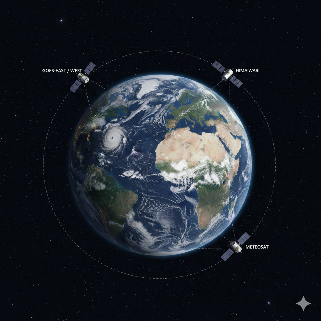
Three expensive space cameras form a ring around Earth’s equator. They’re not drifting aimlessly — each one parks at a specific spot and just stays there, watching. Forever. Bit creepy if you think about it.
The trick? They rotate at exactly Earth’s speed. Like sitting on a carousel while staring at someone standing still — from where you’re sitting, they look stationary. These satellites see the same chunk of planet 24/7.
Why They Matter for Your Forecast
Think of your doorbell camera, except instead of catching porch pirates, it photographs entire continents every ten minutes.
What makes them useful:
They spot hurricanes when they’re basically just cranky clouds. Your local weather station can’t do that. They track wildfires spreading faster than rumors in a tight-knit neighborhood. They catch blizzards forming over oceans before anyone onshore knows what’s coming.
Meteorologists dump this into computer models to figure out if you need an umbrella tomorrow. Pretty nuts that your umbrella decision depends on hardware that costs more than most houses.
Geostationary Orbit Explained
What “Geostationary” Actually Means
Sounds like Star Trek terminology, but stick with me — this part’s legitimately cool.
Picture yourself 22,236 miles up. That’s roughly driving from NYC to Sydney twice. At this exact height, moving at precisely the right speed, you hover over the same Earth spot. No drift. No wandering off. Locked in place.
Why This Matters
Storms are dramatic. A hurricane can escalate from “kinda breezy” to “evacuate immediately” in six hours. Tornadoes form while you’re making breakfast.
If your satellite lazily orbits Earth and only photographs Kansas twice daily, you’ll miss the tornado that just demolished someone’s barn.
Geostationary satellites provide non-stop livestreams of weather throwing fits. That’s how forecasters go from “looks cloudy” to “everyone out, now” with enough warning to actually leave.
GOES Satellites: America’s System
What GOES Means
Geostationary Operational Environmental Satellite. NASA didn’t hire poets for naming. But these satellites make up for boring names by being absolute workhorses.
Coverage Areas
NOAA runs two GOES satellites:
GOES-East monitors the Atlantic and eastern Americas. Hurricane forming near Florida? This satellite’s watching like a hawk.
GOES-West covers the Pacific and western regions. California wildfires? Pacific typhoons approaching Hawaii? GOES-West sees it all.
Together, they cover both hurricane breeding grounds and basically all of America. Good thing, because American weather is chaotic.
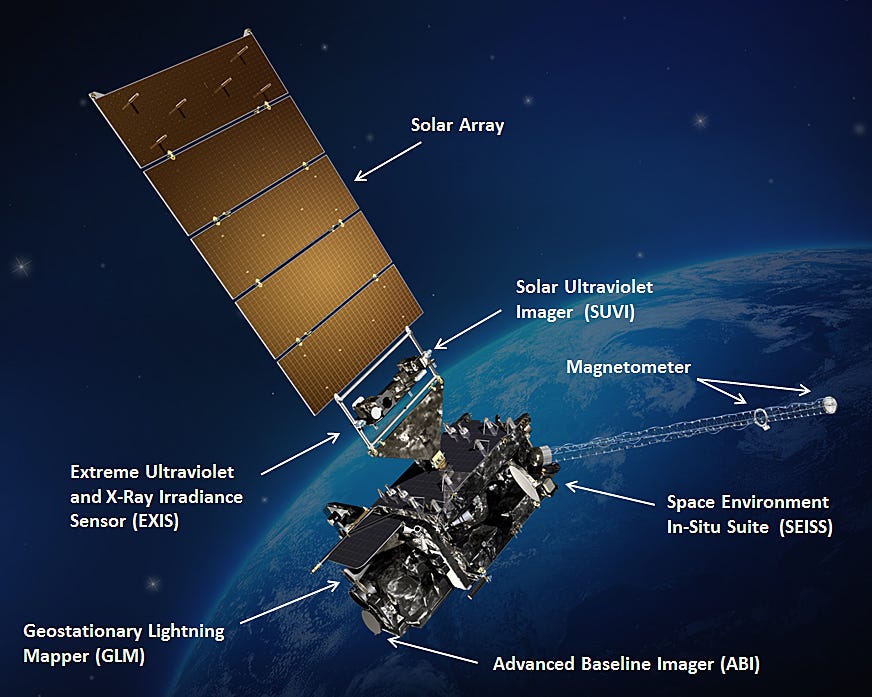
The Advanced Baseline Imager
Current satellites carry something called the Advanced Baseline Imager — fancy name for a camera shooting in 16 different wavelengths. Some you can see, most you can’t.
Why 16 different views? Clouds are complicated liars:
- Visible light shows cloud shapes
- Infrared measures temperature and cloud height
- Water vapor channels reveal invisible moisture
- Special bands detect wildfire smoke, volcanic ash, and even Saharan dust crossing the Atlantic
Hurricane Tracking Mode
During hurricane season, GOES-East switches to “mesoscale mode” — photographing the same area every 30 seconds. Faster than most people’s TikTok attention span.
Those rapid hurricane loops on The Weather Channel showing churning eye walls? That’s mesoscale mode at work. High-speed footage of a Category 4 about to wreck someone’s week.
Real Example: Hurricane Dorian
I watched GOES-16 track Hurricane Dorian in 2019. The satellite captured its evolution from regular tropical storm to catastrophic Category 5 so clearly that forecasters warned Bahamian residents days ahead. Thousands of lives saved because scientists watched the storm evolve in near real-time from space.
That’s not just cool tech — that’s the difference between preparing and dying.
Himawari Satellites: Japan’s Network
What “Himawari” Means
Switch to the western Pacific, and you’re in Himawari territory. “Himawari” means sunflower in Japanese. Adorable, until you realize this sunflower watches typhoons that make Atlantic hurricanes look polite.
Coverage and Position
Japan launched Himawari-8 in 2014, revolutionizing weather monitoring across Asia and Oceania. Parked at 140.7 degrees east longitude over the equator, Himawari has front-row seats to Earth’s most violent weather.
This is typhoon alley. Same storms Americans call hurricanes, just nastier.
What Himawari Does
Himawari carries nearly identical tech to GOES — 16 spectral bands, 10-minute full scans, rapid updates when storms intensify. Different mission though:
- Monitor the western Pacific warm pool where most typhoons spawn
- Watch volcanic eruptions across Indonesia and the Philippines (critical for aviation — ash turns jet engines into expensive paperweights)
- Track massive dust storms from China’s Gobi Desert
- Follow monsoon systems billions depend on for farming
Ocean Temperature Detection
Himawari excels at spotting subtle ocean temperature shifts. Matters because typhoons are heat-powered engines. Spot one heading toward warm water? It’s about to intensify.
Australian Bushfire Monitoring
Australia relies heavily on Himawari. The country’s massive with relatively few ground radars (the outback’s really empty). Satellite coverage fills critical gaps.
During bushfire season, Himawari spots new fires within minutes and tracks smoke plumes across thousands of kilometers. When half the country’s burning, having a satellite watching for flames is essential.
Meteosat Satellites: Europe and Africa
Coverage Areas
Cross back to the prime meridian (zero degrees longitude), and you’ll find Meteosat. Europe operates several satellites covering Europe, Africa, and the Indian Ocean.
Meteosat-11 Position
Meteosat-11 sits right at zero degrees longitude — directly above where the equator meets the prime meridian. From this spot, it watches everything from Iceland to South Africa, Azores to the Arabian Peninsula.
Tons of real estate. Very different weather patterns.
The Lightning Imager
The newest satellite, Meteosat Third Generation (MTG), launched in 2022 with something genuinely innovative: a lightning detector.
This Lightning Imager tracks every single lightning strike across Europe and Africa in real-time. Not just “lightning somewhere over there” but “here’s exactly where that bolt hit.”
Why Lightning Matters
Lightning reveals what’s happening inside thunderstorms where satellites can’t see. More lightning equals stronger updrafts equals more severe weather incoming.
Forecasters spot storms intensifying before they start dropping golf ball-sized hail or spinning tornadoes. Early warning saves lives and property.
Africa’s Dependence on Meteosat
For Africa, Meteosat’s often the only consistent weather monitoring available. Many African nations lack extensive radar networks or weather balloon programs (expensive stuff). Satellite imagery provides the foundation for drought monitoring, agricultural planning, and cyclone warnings.
I’ve seen drought forecasts based on Meteosat data help humanitarian groups prep food aid months before crises peak. That’s satellites doing quiet, unglamorous work daily — preventing famines before they start.
How Satellite Data Reaches Your Phone
The Journey from Space
Ever wonder how pictures from 22,000 miles up appear on your phone within minutes? Process is actually slick:
- Satellite continuously scans Earth with sensors, building images line by line
- Beams raw data to ground stations using radio waves (gigabytes per hour)
- Processing facilities convert raw data into calibrated images
- Meteorological agencies distribute processed imagery through networks
- Weather apps and forecast models grab these feeds
Processing Speed
The whole pipeline from satellite to smartphone usually takes under ten minutes. Sometimes under five.
An image traveled 22,000 miles through space, got processed by supercomputers, routed through networks, and landed on your screen faster than deciding breakfast.
GIS and Weather Satellites
What GIS Does
Raw satellite images are useful, but Geographic Information Systems (GIS) make them powerful. GIS platforms layer satellite imagery with maps, terrain, population info, and infrastructure.
Like taking a photo and adding context about everything in it — who lives there, what’s built there, what could go wrong.
Emergency Management Example
Hurricane approaching the Gulf Coast. Emergency managers load latest GOES imagery into GIS, then overlay:
- Evacuation zones
- Hospital locations
- Flood-prone areas
- Major highways
- Power grid infrastructure
- Schools and nursing homes
Now they see exactly which neighborhoods evacuate first, which roads flood and block evacuation routes, where to position emergency supplies. Difference between chaos and coordinated response.
Other Applications
Farmers combine satellite data with field boundaries and soil maps, spotting crop stress before yields tank.
Insurance companies use historical satellite imagery to assess flood and fire risks (and charge accordingly).
Electric utilities watch storms approaching transmission lines, prepping repair crews before outages happen.
Personal Experience
I worked on a project using Himawari data to map wildfire smoke movement across Southeast Asia. Combining satellite imagery with wind data and population density in GIS, health officials issued air quality warnings before smoke arrived.
Simple concept requiring multiple spatial data sources. That’s GIS power — connecting dots satellites alone can’t.
Comparing the Three Systems
Regional Strengths
Each does roughly the same job, optimized differently:
GOES covers the Americas. Hurricane in the Atlantic? Blizzard over the Rockies? That’s GOES data. Particularly good at rapid scanning of severe US weather.
Himawari monitors Asia and Oceania. Typhoons, monsoons, volcanic eruptions — Himawari’s specialty. Japanese meteorologists pioneered many rapid-scan techniques now used worldwide.
Meteosat handles Europe, Africa, and Indian Ocean. Its lightning imager is unique among geostationary weather satellites. Coverage of Africa provides irreplaceable data for a continent with limited ground observations.
Global Coverage
Between these three, you get almost complete global coverage. Only polar regions need different satellites — polar-orbiting ones flying much lower, circling over the poles.
Three security guards watching different building sections. Together, they see everything.
Future Technology
Next Generation Plans
NASA and NOAA are already planning next GOES generation with higher resolution and faster scanning. Europe’s working on additional MTG satellites.
Coming Developments
Some interesting stuff in the pipeline:
- Machine learning algorithms automatically detecting tornadoes, hail, and flooding. AI catches danger without human eyes.
- Hyperspectral imagers photographing Earth in hundreds of wavelengths, revealing atmospheric chemistry in unprecedented detail
- Improved nighttime sensors seeing cloud details in darkness without relying solely on infrared
- Even faster scanning — experimental systems refreshing every minute or less
The Goal
Not just prettier pictures. Better satellite data means better forecasts, earlier warnings, ultimately fewer casualties when severe weather hits.
Every satellite improvement translates to lives saved and property protected. Worth the billions invested.
Accessing Satellite Imagery Yourself
Free Tools
Want to explore weather satellites? Several sites let you access the same imagery meteorologists use:
NOAA’s GOES Image Viewer shows live GOES imagery with various enhancements. Official source, straight from NOAA.
Zoom Earth combines data from all three systems into a clean, interactive globe. Super user-friendly, updates every ten minutes.
RAMMB Slider (Colorado State University) offers incredibly detailed satellite loops and comparisons. Where weather nerds hang out.
NASA Worldview provides access to multiple satellites with layers for fires, smoke, aerosols, and more.
Real-Time Updates
Most update every ten minutes. You can watch weather systems evolve in near real-time. Never gets old.
I still check satellite loops when big storms brew, even on days off. Once you watch weather from space, weather apps feel boring.
Common Questions
How Often Do They Photograph?
Full disk scans every ten minutes. During severe weather, they focus on smaller areas shooting images every 30 seconds to one minute.
Rapid-fire capability is crucial for fast-changing storms. Tornadoes and flash floods don’t wait around.
Can They See Through Clouds?
Depends on wavelength. Visible cameras can’t — you just see fluffy tops. But infrared sensors detect heat from different atmospheric levels, determining cloud height, temperature, and what’s lurking below.
Water vapor channels show moisture at different altitudes even when clouds block direct view. X-ray vision for atmosphere.
How Accurate Are Forecasts?
Satellites observe, they don’t forecast. But their data feeds forecast models, dramatically improving accuracy.
Three-day forecasts now match one-day forecasts from the 1990s. Hurricane track forecasts improved about 50% over twenty years, mostly from better satellite observations.
We’re literally twice as good at predicting hurricane paths compared to two decades ago. Massive for evacuation planning.
Do They Work at Night?
Absolutely. Infrared sensors work 24/7 because they detect heat, not visible light.
Some of the most dramatic imagery comes from nighttime infrared — thunderstorms exploding in darkness, tops glowing cold in infrared, lightning illuminating massive cloud structures.
Night doesn’t stop weather. Doesn’t stop satellites watching it.
What About Polar-Orbiting Satellites?
Geostationary satellites (GOES, Himawari, Meteosat) orbit at 22,236 miles, staying fixed over one location. Great for continuous regional coverage.
Polar-orbiting satellites fly much lower — around 500 miles — passing over poles as Earth rotates beneath. They provide global coverage with higher resolution but only pass any location twice daily.
Both types essential. Geostationary gives you the movie. Polar gives you high-definition snapshots.
Why This Matters
Daily Impact
Weather satellites might be invisible to most people, but they touch nearly everything:
- Agriculture depends on satellite data for irrigation and crop monitoring
- Aviation routes flights around dangerous weather
- Shipping avoids storms at sea
- Emergency management coordinates disaster response
- Energy production forecasts solar and wind
- Insurance assesses risks from historical data
Saving Lives
When forecasters tell coastal residents to evacuate before a hurricane, that warning exists because satellites spotted the storm days earlier and tracked its intensification hour by hour.
When farmers optimize irrigation during drought, satellite data shows exactly which fields need water, conserving resources.
When airlines route around severe turbulence, they’re using real-time satellite imagery processed minutes earlier.
The Hidden Infrastructure
GOES, Himawari, and Meteosat quietly orbit above, watching weather develop and dissipate, sending data that saves lives and protects property every single day.
Next time you check your weather app and grab an umbrella, appreciate the engineering marvel 22,000 miles overhead that made that forecast possible. These satellites are humanity’s early warning system, our eyes in the sky, honestly one of our best investments as a species.
They’re not as famous as SpaceX launches or Mars rovers, but weather satellites are unsung heroes keeping billions safe from nature’s worst tantrums.
메타데이터
- post_id
- 204ab70f1efb
- slug
- how-satellites-track-weather-a-beginners-guide-to-goes-himawari-meteosat-204ab70f1efb
- url
- https://medium.com/@niharrm.2001/how-satellites-track-weather-a-beginners-guide-to-goes-himawari-meteosat-204ab70f1efb
- canonical_url
- https://medium.com/@niharrm.2001/how-satellites-track-weather-a-beginners-guide-to-goes-himawari-meteosat-204ab70f1efb
- author_url
- https://medium.com/@niharrm.2001
- status
- ok
- fetched_at
- 2026-06-12 07:40:50