Where the Country First Sees the Sunlight: Acadia National Park
From its ruggedly beautiful coastline to its mountains (including the tallest one on the East Coast), where the country first sees the…
Where the Country First Sees the Sunlight: Acadia National Park
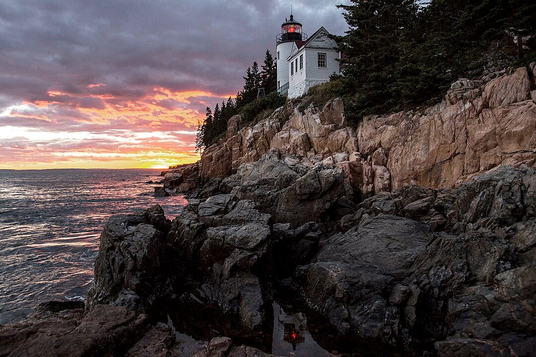
Bass Harbor Lighthouse
From its ruggedly beautiful coastline to its mountains (including the tallest one on the East Coast), where the country first sees the sunlight, Acadia National Park is full of amazing surprises. It was once the retreat for the country’s legendary wealthy elite, the likes of the Rockefellers, Carnegies, and Vanderbilts. Yet thanks to those same families and others who wanted to preserve this tranquil spot for generations to come, it is now a place for all to enjoy. Though small (49,000 acres), it packs a punch. So, pack your bags and get ready to enjoy the first national park established east of the Mississippi.
Located along Maine’s coast southwest of Bar Harbor, it is the only park in the Northeast and contains wonderful sights like Mount Desert Island and Cadillac Mountain, and woven into this landscape is a historic carriage road system financed by John D. Rockefeller, Jr. All of this draws a crowd (around 4 million visitors per year), making it the nation’s sixth busiest park.
Geography

Map of Acadia National Park, located on Mount Desert Island, Maine
The park includes mountains, an ocean coastline, woodlands, lakes, and ponds. Encompassing nearly half of Mount Desert Island, the park preserves a portion of the Schoodic Peninsula on the mainland, along with many other islands, including Isle au Haut, Baker Island, Bar Island, Porcupine Islands, Bear Island, and Thompson Island. Bar Island can be visited on foot over a sandbar around low tide. Acadia encompasses 49,075 acres (76,680 sq miles), the majority of which are on Mount Desert Island.
The mountains of Acadia overlook the Atlantic Ocean, island lakes, and pine forests. Twenty-six major peaks range from the 284-foot Flying Mountain to the 1,530-foot Cadillac Mountain. Named after the French explorer, Cadillac Mountain is the tallest mountain along the East Coast. Its summit is the first place in the United States where one may watch the sunrise.

Sunrise from the summit of Cadillac Mountain
The 27-mile Park Loop Road leads to many scenic viewpoints and connects several of the park’s popular spots, including Cadillac Mountain, Champlain Mountain, Sand Beach, the Beehive, Gorham Mountain, Thunder Hole, and the Tarn. Other features include Echo Lake and beach (freshwater swimming area), Acadia Mountain, Beech Mountain, Long Pond, and Seal Cove Pond. The park also includes three lighthouses: Bass Harbor Light (located on top of a cliff on the southwestern tip), Baker Island Light, and Bear Island Light. Somes Sound, a five-mile-long fjord, divides the island in half.
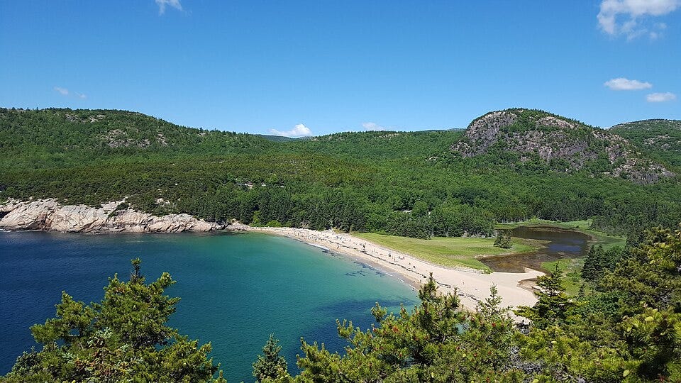
Sand Beach and the Beehive (mountain to the right)
History
Native People
Native Americans have inhabited the area called Acadia for at least 12,000 years, and have been the center of the Wabanaki ancestral homeland. The Wabanaki Confederacy (“People of the Dawnland”) consists of five related Algonquin nations — the Maliseet, Mi’kmaq, Passamaquoddy, Abenaki, and Penobscot. The park’s namesake begins with the Mi’kmaq term akadie (“piece of land”), which was rendered l’Akadie by French explorers, and translated into English as Acadia.
The Wabanaki traveled to the island in birch bark canoes to hunt, fish, gather berries, harvest clams, and gather basket-making resources such as sweetgrass, and to trade with other Wabanakis. They camped near places like Somes Sound.

Replica of a Penobscot birchbark wigwam
In the early 17th century, Castine, a favored rendezvous spot for the tribes, became a major trading post where French, English, and Dutch traders fought for control. Sealskins, moose hides, and furs were traded for European commodities. Yet, by the early 1620s, warfare, along with introduced diseases, including smallpox, cholera, and influenza, had decimated the tribes, leaving around ten percent of the original population. The border between the United States and Canada, established after the American Revolution, split the Wabanaki homelands. Around 1870, the confederacy was dissolved due to pressure from both governments, though the tribes continued to interact. They sold baskets to travelers and performed dances for tourists and residents. Their guides led canoe trips around Frenchman Bay and the Cranberry Islands.
Currently, each tribe has a reservation and government headquarters throughout their territories in Maine, and some Wabanakis live on Mount Desert Island. They advise on and perform in exhibitions, for craft demonstrations, and to gather sweetgrass and sell handmade baskets at the annual festival.
Exploration
In 1524, the Italian explorer Giovanni de Verrazzano sailed along the coast of Mount Desert Island during an expedition for the French crown. He was followed by the Portuguese and French. The French explorer, Jean Alfonse, arrived in 1542 and entered Penobscot Bay; he recorded details about the fur trade. In 1604, a few hundred people were living on Mount Desert Island when Samuel de Champlain arrived.

Mount Desert Island from Baker Island
Two Wabanakis led Champlain to Mount Desert Island, which he named Isle des Monts Deserts (Island of Barren Mountains) due to its barren peaks. He also named Isle au Haut (High Island) due to its height.
Settlement
The first French missionary colony in America was established on Mount Desert Island in 1613. The colony was destroyed a short time later by an armed vessel from the Colony of Virginia. It was the first act of warfare in the long struggle leading to the French and Indian War. The island was granted to Antoine de la Mothe Cadillac by Louis XIV in 1688, but ceded to England in 1713. The 1st Baronet Sir Francis Bernard, governor of Massachusetts, assumed control of the island in 1760, and in 1790, the colony granted the eastern half of the island to Cadillac’s granddaughter, Mme. de Gregoire, while the western half to given to Bernard’s son, John. In 1855, the first summer visitors vacationing on the island were recorded, and in 1868, steamboat service from Boston was inaugurated. The Green Mountain Cog Railway was built from the shore of Eagle Lake to the summit of Cadillac Mountain in 1888 and ran until 1890. In 1901, the Maine Legislature granted Hancock County a charter to acquire and hold land in the public interest. The first land was donated in 1908, and by 1914, five thousand acres had been acquired.

Green Mountain Cog Railway
“Rusticators”
By the mid-1800s, the island had become popular due to the work of artists and journalists. Painters from the Hudson River School, including Thomas Cole and Frederick Church, inspired friends and patrons to visit. The term rusticator was used to describe these early visitors who stayed in the homes of local fishermen and farmers for a modest fee. These accommodations soon became insufficient for the rising crush of summer visitors, and by 1880, thirty hotels were operating on the island. Tourism was becoming a major industry.
Cottagers
For the fortunate few, the 1880s and 1890s, also known as the Gilded Age, meant fortunes on an unprecedented scale. Due to its remote location, Mount Desert Island became a summer retreat for the Rockefellers, Morgans, Fords, Vanderbilts, Carnegies, and Astors. These families built elegant estates, which they ironically called cottages. Luxury, refinement, and large gatherings replaced the buckboard rides, picnics, and day hikes of the rusticators. For more than forty years, the wealthy elite dominated summer activity on the island, but the Great Depression and Second World War brought an end to the extravagance.
Birth of the Park

George B. Dorr and Charles W. Eliot on the shores of Jordan Pond
Landscape architect Charles Eliot is credited with the idea of the park. George B. Dorr, called the “Father of Acadia National Park,” along with Eliot’s father, Charles W. Eliot (Harvard president from 1869 to 1909), supported the idea through land donations and advocacy at the state and federal levels. Dorr later served as the park’s first superintendent. President Woodrow Wilson first established its federal status as Sieur de Monts National Monument on July 18, 1916, administered by the newly formed National Park Service. It was the first national park created from private lands gifted to the public.
Congress redesignated it as Lafayette National Park on February 26, 1919, the first national park established east of the Mississippi River and the only one in the Northeast. It was named after the Marquis de Lafayette, an influential French participant in the American Revolution. Construction of the Jordan Pond Road began in 1922 and was completed in 1927 as a scenic motorway. The Cadillac Mountain Summit Road was finished in 1931.
A decade later, on January 19, 1929, the name of the park was changed to Acadia, in honor of the former French colony, which included Maine. From 1915 to 1940, the wealthy philanthropist John D. Rockefeller, Jr., financed, designed, and directed the construction of a network of carriage roads throughout the park. Of the original 57 miles of road, around 45 are still maintained and are accessible within the park. Granite coping stones along carriage road edges act as guard rails and are known as “Rockefeller’s teeth.” The roads are open from the end of the spring mud season (late April) through the spring, autumn, and winter months until the following spring thaw causes another closure in March to prevent damage to the gravel surface.

Carriage road
Fire of 1947
Beginning on October 17, 1947, more than ten thousand acres of the park burned along with an additional seven thousand acres on the island outside the park. It burned until November 14 and was fought by the Coast Guard, Navy, National Park Service, and local residents. Sixty-seven of the historic cottages along Millionaire’s Row, along with 170 homes and five hotels, were destroyed. Restoration of the park was substantially funded by the Rockefellers. Regrowth has occurred naturally with deciduous birch and aspen trees, which have enhanced the fall foliage; spruce and fir forests have also regenerated.
Current Issues
Park attendance has been on the rise and setting new records, including over four million visitors in 2021. The seasonal nature of the park has resulted in a concentration of visitors in the summer months that is beyond the capacity of the park's infrastructure. Congestion has led to a lack of available parking and gridlock, requiring road closures. Traffic management has taken its toll on park rangers competing with rescue operations which see a spike during peak attendance. The Island Explorer bus system is offered to help reduce congestion.
The cost of infrastructure maintenance has been estimated to be around $66 million, and the National Park Service has estimated that total deferred maintenance across all units to be around $11 billion. This backlog compounds existing issues with environmental maintenance and traffic congestion, as infrastructure to manage traffic flow cannot be built until existing infrastructure is properly maintained. Trail and wilderness restoration is also deferred due to insufficient funding. Additionally, the large number of park entrances creates issues with fee compliance, costing additional lost revenue.
Recreation
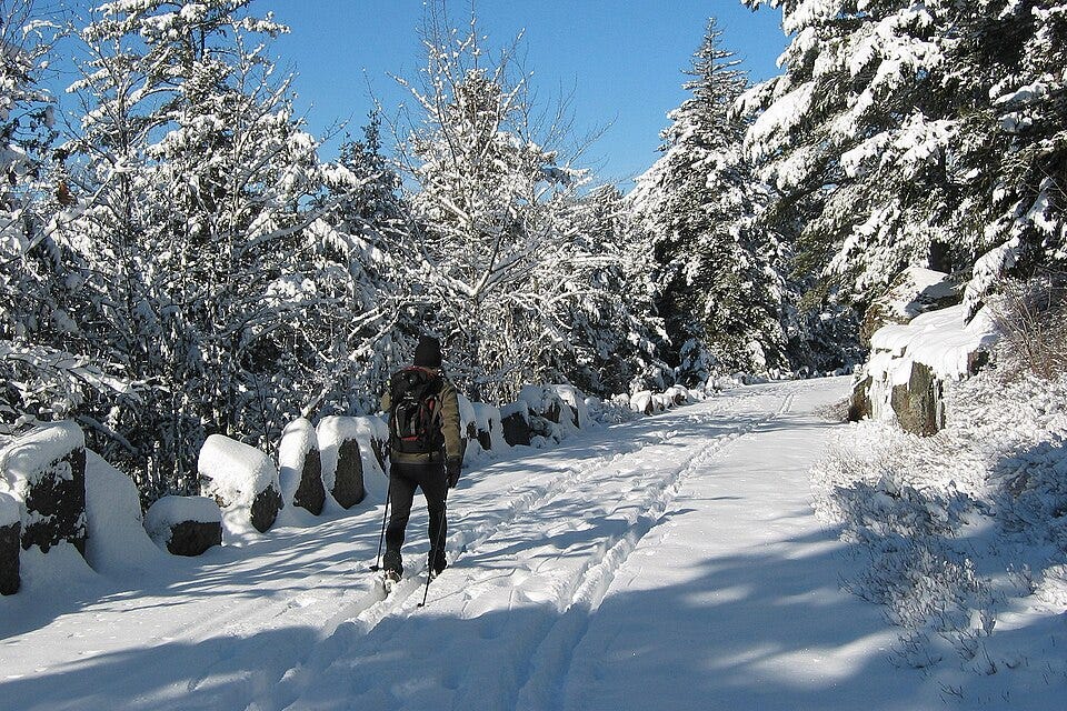
Cross country skier on a carriage road
Motor vehicle touring along the 27-mile Park Loop Road begins on April 15 (weather permitting) and ends on December 1. The coastline can also be explored via guided boat tours or sea kayaking. Canoeing and kayaking are also popular activities on available lakes and ponds. About 125 miles of hiking trails traverse the forests and mountains, and 45 miles of carriage roads can also be hiked or bicycled (motorized vehicles and electric bikes are prohibited). Horseback riding is permitted on carriage roads and other park areas. Climbing is also a popular activity at Otter Cliff, Great Head, Precipice, and South Bubble. Sand Beach offers seawater swimming, and Echo Lake offers freshwater swimming.
Winter activities include snowshoeing, cross-country skiing, snowmobiling, and ice fishing.
From mid-May to mid-October, ranger-led programs introduce visitors to Acadia’s diverse natural and cultural history, and these include walks, hikes, boat cruises, evening amphitheater programs, and children’s programs, along with viewing of peregrine falcons and raptors.

Park Loop Road
Mount Desert Island has two NPS campgrounds built by the Civilian Conservation Corps: Blackwoods on the east side of the island, close to the popular sites and Bar Harbor, along with Seawall on the less crowded west side. There are also eleven private campgrounds outside park boundaries.
In September, the park hosts the annual Acadia Night Sky Festival, attracting speakers, researchers, photographers, and artists to the area.
Must-See Sites
Cadillac Mountain

Cadillac Mountain viewed from Champlain Mountain
No visit to Acadia would be complete without visiting this mountain. At 1,530 feet, it is the tallest peak on the eastern seaboard, and it played a major role during World War II for early warning warcraft detection. The mountain’s height and location made it an ideal spot for a radar facility to achieve strong signals. Today, it is still used for communication by the police, National Park Service, Coast Guard, and fire department. From 1883 to 1893, the Green Mountain Cog Railway ran visitors to the summit and the Green Mountain Hotel. The hotel burned down in 1895, and the railway was eventually sold and moved to the Mt. Washington Cog Railway in New Hampshire. Today, the summit can be reached via the Cadillac Mountain Summit Trail. This 0.5-mile round trip is mostly flat, and from the top, you can see for miles in every direction.
It is known as the first place in the continental U.S. to see the sunrise, but that is only true between October and March. Many people crowd the summit to watch the sunrise and sunset, but if you can find a parking spot, it is absolutely worth it. Just be aware that reservations may be needed to drive to the summit.
Getting Here
From the Hulls Cove Visitor Center, drive south on the Park Loop Road for 3.5 miles until you reach the turnoff for Cadillac Mountain Summit Road. Turn here and follow the road for another 3.4 miles. The road is closed between December and April, and anytime the weather is inclement.
Bar Island

Bar Island at high tide, at low tide something amazing happens
Bar Island is a tidal island across from the town of Bar Harbor. It is uninhabited and forested, and there are walking trails. At low tide, something magical occurs: a pathway emerges from the ocean to this beautiful isle. An hour-and-a-half before and after the low tide, a gravel bar (land bridge) makes Bar Island accessible. Visitors walk across to the island or park their cars on the exposed bar. However, on the island side in front of a locked gate, only a small area fringed with dense sea rose bushes is elevated enough to provide safe parking. Just don’t linger too long. The trail disappears back into the sea just as quickly as it appears! Visitors have been known to come back from their hike to find their cars submerging and themselves stranded until the tide recedes again. In other words, time your hike carefully and keep an eye on your watch. Getting rescued from the island is very expensive!
Upon reaching the island, a trail takes you to the top of the island, where you will find amazing views of Bar Harbor and the surrounding mountains. Round trip is 1.6 miles with an elevation gain of 160 feet.
Getting Here
Parking can be found in Bar Harbor. There’s also a free shuttle from the Hulls Cove Visitor Center to the center of town. From the Village Green bus stop, walk to Main St and turn left. Walk 0.2 miles and turn left on West St. Walk another 0.2 miles and turn right on Bridge St. Follow it down to the gravel bar that appears at low tide. This is the start of the trail.
Carriage Roads

Duck Brook Bridge
Go back in time and see the park as it was back in the early twentieth century. John D. Rockefeller, Jr. had a vision of motor-free roads that traversed Acadia, and that vision can still be experienced today. Explore the interior of the park on these 45 miles of rustic paths. Biking, hiking, and horse-drawn carriages are all popular means of doing so. Look for the beautiful gate lodges and characteristic stone-faced bridges along the way.
Getting Here
The carriage roads can be accessed from many different areas of the park. If you signed up for a carriage ride, you’ll need to make your way to the Wildwood Stables to start your tour. The stables are located a half mile south of the Jordan Pond House.
South Bubble

Bubble Rock
This prominent peak can be seen from the shores of Jordan Pond. If you want to catch the view from the top, you will need to do a little hiking. From there, you can get a 360-degree view of Acadia. The top of South Bubble can be reached via a one-mile round-trip hike with an elevation gain of 250 feet. Follow the signs for South Bubble and Bubble Rock; another trail branches off to North Bubble. Make sure to follow the cairns (rock stacks) and blue blazes to get to the summit, which is a large stack of rocks as you ascend the hill. From there, there is a small spur trail to Bubble Rock. After seeing Bubble Rock, continue along the main trail until the view opens up. You can see Jordan Pond, Atlantic Ocean, North Bubble, and Penobscot Mountain. Once you’re finished, just turn around and go back the way you came.
You may see a trail that continues in front of you. But be warned, this trail goes steeply down the side of the mountain to Jordan Pond and is not recommended unless you enjoy scrambling down rocks on your hands and knees. Parking is very limited.
Getting Here
South Bubble is located along the Park Loop Road. From the Hulls Cove Visitor Center, drive south along the road for six miles until you reach the parking lot for the South Bubble.
The Ocean Path

Otter Cove from Otter Point
This beautiful path starts at Sand Beach and goes for two miles one-way to Otter Point. Just mind you, this path is busy and follows the road for most of the time. So, you won’t find any peace and quiet here. Yet it does provide easy-to-access coastline views. It is also possible to drive to points of interest along the path. Just make sure to stop at Thunder Hole. If you are lucky, you will hear the loud thundering waves as the tide comes in. There are also the Otter Cliffs and Otter Point as points of interest.
Getting Here
The Ocean Path is along the one-way Park Loop Road. From the Hulls Cove Visitor Center, drive south on the Park Loop Road for three miles. Turn left at the fork in the road following the signs for Sand Beach. Drive for another 5.5 miles. You will pass the entrance station, and then the parking area for Sand Beach will be on your left.
Beehive Trail
This is Acadia’s most famous trail, but it is not for everyone. It will test your limits as you utilize iron rung handholds, footholds, and bridges to reach the mountaintop. This trail is 1.5 miles round-trip with an elevation gain of 500 feet. This trail will feel more like you are climbing the mountain rather than hiking it. It is critical to be well prepared with sturdy hiking shoes that have good traction. You do not want to be hiking this when the rocks are wet! The views are spectacular and reward the effort. After reaching the top, don’t go back the same way. Head down the backside of the mountain instead and get to the bowl. Follow the shoreline of the bowl for a minute. Hang a left to stay on the Bowl Trail and circle back down to the trailhead.
Getting Here
The trail is located along the Park Loop Road. Parking can be found at Sand Beach.
Sand Beach
Sand Beach and Beehive Mountain
Tucked in between Acadia’s pink granite rocks is this sparkling beach. Sand beaches are a rarity here, so it is incredibly popular. Changing areas are available in the parking area if you want to go swimming. Just be aware that the water is around 55 degrees, so it’s an invigorating swim. Pets are not allowed on the beach between May 15 and September 15.
Getting Here
From the Hulls Cove Visitor Center, drive south on the Park Loop Road for three miles. Turn left at the fork in the road following the signs for Sand Beach. Drive for another 5.5 miles. You will pass the entrance station, and then the parking area for Sand Beach will be on your left.
Jordan Pond

Formed by the Wisconsin Ice Sheet, this iconic pond covers 187 acres and has a depth of 150 feet with a shoreline of almost four miles. Penobscot Mountain (1194 ft) rises to the west while Pemetic Mountain (1247 ft) rises to the east. The Bubbles (north and south) are along the northeastern shoreline. The waters are clear and pristine with normal visibility of around 44 feet. Take a relaxing stroll and then sit on the lawn and enjoy a warm, fluffy popover that has been served at the Jordan Pond House since the 1890s. Popover? It’s a muffin that has been made out of an eggy batter. As it bakes, the inside becomes hollow, and the outside is nice and crispy. They are usually served with butter and jam. Fancy an afternoon tea on the lawn of the House? It’s a park tradition, but reservations are recommended.
There is a 3.3-mile path around the pond, and it is fairly level. You don’t have to go the whole way round to enjoy a stroll.
This is the public water source for the town of Seal Harbor, so swimming or entering the water is prohibited. But kayaking and canoeing are allowed.
Getting Here
The pond is located along the Park Loop Road. From the Hulls Cove Visitor Center, drive south along the road for 7.6 miles until you reach the Jordan Pond House. The path around the pond is located on the back side of the house.
Gorham Mountain
It is not the highest peak nor the most well-known, but the hike is well worth it, granting spectacular views to whoever makes it to the top. The hike to the top of Gorham Mountain is 1.8 miles round trip with an elevation gain of 500 feet, and the hike is family-friendly. Look for the pile of rocks and the sign that marks the top, as you’ll want to turn around here. The trail continues to the Beehive and Sand Beach, so make sure to turn around unless you want a longer hike.
Getting Here
Gorham Mountain is located along the Park Loop Road. From the Hulls Cove Visitor Center, drive south on the Park Loop Road for three miles. Turn left at the fork in the road following the signs for Sand Beach. Drive for another seven miles. You will pass through an entrance station, the parking lot for Sand Beach, and the parking lot for Thunder Hole. Just after the Thunder Hole Parking Lot, look for the sign for Gorham Mountain on the right. It’s the trailhead.
Bass Harbor Head Lighthouse

The history of the lighthouse dates back to 1855, when it was determined that there was sufficient reason to build a light at the entrance of Bass Harbor. Congress appropriated $5000 for its construction, which was completed in 1876. The lighthouse is on the National Register of Historic Places. And you can experience the power and beauty of this light along this treacherous coast, which has guided weary travelers home for generations. It is still a navigation aid, and so tours inside the buildings are not allowed. The house today is home to a local Coast Guard member and his family. You can get close to the bell and light via a concrete path, but most of the grounds remain private.
From the parking area (which is small), there are two small trails. To the right, there is a wide path that leads directly to the lighthouse and provides lovely views of the sea.
To the left (near the restrooms) is a smaller, more challenging route that heads down the cliff to the famous viewpoint of the lighthouse with the rocky shoreline. Take care, though, as the rocks can be slippery and dangerous from the pounding waves.
The grounds are open from 9 a.m. to sunset.
Getting Here
The light is located in the southwestern section of the park and is a thirty-minute drive from the Hulls Cove Visitor Center. From the visitor center, drive west on either Crooked Road or Eagle Lake Road to reach Highway 102 South. Drive south on Highway 102 passing through the town of Southwest Harbor. After eleven miles, take a slight left when the road to follow Highway 102A towards Bass Harbor. Continue until the road dead ends at the lighthouse.
Conclusion

Acadia National Park is a jewel along America’s Atlantic coast. Thanks to the efforts of Rockefeller and others, this beautiful area of the coast remains pristine and able to be enjoyed by all.
메타데이터
- post_id
- 26f87b3a12fc
- slug
- where-the-country-first-sees-the-sunlight-acadia-national-park-26f87b3a12fc
- url
- https://medium.com/@swgorham/where-the-country-first-sees-the-sunlight-acadia-national-park-26f87b3a12fc
- canonical_url
- https://medium.com/@swgorham/where-the-country-first-sees-the-sunlight-acadia-national-park-26f87b3a12fc
- author_url
- https://medium.com/@swgorham
- status
- ok
- fetched_at
- 2026-07-14 22:58:46