Ngari Triptych Part 3: Guge — The Lost Kingdom
Almost a decade ago, in the Autumn of 2016, I made an unforgettable journey, or rather pilgrimage, to three iconic locations in the Far…
Ngari Triptych Part 3: Guge — The Lost Kingdom
Almost a decade ago, in the Autumn of 2016, I made an unforgettable journey, or rather pilgrimage, to three iconic locations in the Far West of Tibet, known in the vernacular as Ngari. Over the following year or so, I wrote a blog, chronicling the core of that journey, which after that languished on my laptop…. until, that is, right now. Here is the third and final part: my visit to the so-called Lost Kingdom of Guge.
The lost kingdom of Guge is another full day’s drive beyond Darchen, the base for doing the three-day kora of Mount Kailash. The route follows the Kashgar Highway for much of the way before turning off for the final approach over a series of bitterly cold, 5000m+ high passes, and never-ending zigzags up and down precipitous hillsides: it is not a route for the faint-hearted driver — or passenger! Kamet (7756m), situated wholly within India but seeming so close, dominated the Himalayan skyline, magnificent, haughty, austere.
Finally, the mountains, their shale lower slopes topped by a rich palette of ochre, malachite greens and dark lavenders, with occasionally a snowy ‘widow’s cap’ as the final touch, gave way to the badlands as the road started to drop down into the valley of the Sutlej — Elephant’s Mouth — River, the source of which is to the east of Kailash. The change in the landscape was accompanied by a corresponding rise in the temperature.
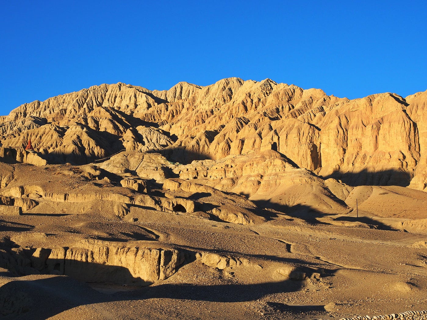
The badlands landscape that surrounds Guge
It was my first time to experience a surreal badlands landscape, and I was overawed: the gothic, sculpted cliffs flanking the canyons seemed to be the creations of some grotesquely inclined architect rather than the work of erosion! The clearly visible horizontal lines indicated the layers of the erstwhile seabed, when this whole region lay beneath the primordial Tethys Sea: but when a dreamy, creative spirit like mine is significantly more than 4000m above the present day sea-level, it does not even want to begin to contemplate, let alone believe, the geological realities of this.
Finally, I arrived in Zhada, at 3760m about 1000m lower than Darchen and thus conducive to easier breathing and deeper, more restful sleep. The little town seemed in the process of expansion, with the clearly visible military presence — and associated services, including brothels — reflecting the ongoing tensions between China and India over the still disputed border with Ladakh. The UV light was particularly intense in Zhada, the heat rising from the ground in the late afternoon causing violent dust-storms in which particles of sand and earth — both natural and from the countless construction sites — were sucked into the air and whirled around like tiny vicious tornadoes, coating everything in a fine gritty film. At first, it all seemed a world away from what I had come to see: the romantic remnants of the Guge Kingdom.
The story of the origins, growth and ultimate collapse of Guge is as complex and obscure as the location is remote and extreme. The assassination of the Tibetan king Langdarma in the mid-ninth century was followed by civil war, and the collapse of the great Tibetan empire. In 910CE Langdarma’s grandson fled westwards to escape the continued instability of the central region, and within two years had conquered the high-altitude desert region of Ngari. His son, Tashi Gon, was the first king of the Guge-Purang Kingdom but it was his successor, Yeshe-Ö (c. 947–c.1024CE), whose religious commitment and determination to reinforce Buddhist practices led to the foundation of a kingdom which was to last for seven centuries.
From his capital at Tholing, Yeshe-Ö’s religious devotion formed an integral part of what is known as the ‘Second Diffusion’ or ‘Second Advancement’ of Buddhism in Tibet. Eager young scholars were sent to study in Kashmir and India: on his return, one of these scholars, Rinchen Zangpo, became a renowned translator of Sanskrit Buddhist texts into Tibetan, hence his moniker ‘Mahaguru’. The prominent Indian sage and abbot — and Rinchen Zangpo’s teacher — Atisha was then invited to Guge-Purang: he introduced South Asian art to Tibet, with the temple murals at Tholing representing a fusion of Indian, Nepalese and Kashmiri styles. One tradition also attributes to Atisha the introduction of using wooden blocks to print the images and mantras on prayer flags.
Gradually, the influence of the Guge-Purang Kingdom spread along the swathe to the south of the Himalayas, from Kashmir to Assam, although the break-up of the kingdom into its two constituent parts, Guge and Purang, at the end of the eleventh century, resulted in its destabilisation.
I had planned to see Tholing Monastery, situated on the edge of Zhada, with its three extant buildings — Main Assembly Hall, White Chapel and Yeshe-Ö’s Mandala Chapel — before twilight. Tholing — the Tibetan roughly translates as ‘hovering eternally in the sky’ — was founded in 997CE by Rinchen Zangpo and was once Ngari’s most important monastery. It was therefore a huge disappointment to find the complex closed to visitors while an extensive reconstruction and renovation programme was being undertaken. The caretaker did not appear to be very happy to even have me peeping through the gap in the chained entrance gates, so I reluctantly gave up and spent a little time at the nearby — and also clearly recently restored — Serkhang Chorten, watching a few locals do the kora. I was particularly intrigued by a highly embellished yak skull that had been reverently placed at the base of the chorten, with a white votive scarf wrapped around and linking its two horns. The brilliant colours of the design, painted over a white background on the skull, conjured up something of the hippy-trippy era of the Sixties: there was clearly much left for me to learn about Tibetan customs and ways.

The ornately decorated yak skull at Serkhang Chorten, Zhada
There was just time to take a look at the valley of the Sutlej River below the escarpment on which Tholing is situated, and stare at the symbolically accurate but stylistically out of place gleaming steel statute of a pachyderm, body twisted and trunk held aloft, before darkness descended.
If Tholing had been a disappointment, then the next day Tsaparang, some 18km to the west, which had assumed the role of the capital of Guge by 1470CE after four hundred years of changing fortunes, was everything I had hoped it would be, and more.

Dawn light over the approach to Tsaparang
I arrived just too late to photo the magical soft pinks and lavenders of dawn: the golden glow of sunrise had already started to bathe the crag on which the citadel had been built. But what a scene! Nothing can quite prepare one for the impact of a face to face encounter with Tsaparang. I was confronted by a site in which the manmade and the natural fused seamlessly in the badlands landscape, the buildings seeming to be organically part of the rocky crag — rising to a height of almost 200m at the end a long, narrow spur — on which they had been partially built, partially excavated. There was something achingly timeless and placeless about it….I could have been gazing in a similar state of awe at the ruins of an Ancient Greek, Mesopotamian, Mayan or any other glorious, long-gone civilization. The citadel had an ineffable aura of majesty and pride, even when confronted by the reality of its own collapse and disintegration. In the soft light of sunrise it glowed and beguiled; under the harshness of the midday sun it seemed bleached to skeletal proportions against a sky that was so intensely indigo that it verged on blackness. It was arid and dry, with just a few wispy, desiccated apologies for grass and low-growing shrubs. And as the sun beat down my eyes started to play tricks with me, seeing buildings where there was only rock, and rock where crumbled buildings stood.

Sunrise at Tsaparang
Initially, the custodian of Tsaparang accompanied me up the steps, hewn into the rock, and in turn unlocked three chapels, standing silently but hyper-vigilantly in the shadows: photography, even without flash, was not permitted. The chapels — Lhakhang Karpo (White Chapel), Lhakhang Marpo (Red Chapel) and Dorje Jigje Lhakhang (Yamantake Chapel) — were all quietly overwhelming and imbued with such a sense of sanctity and antiquity that silence seemed the natural and most fitting way in which to view them. My memories of them as a group are clear — the sudden contrast on leaving the outside glare and entering the gloom; the exquisite and, in many cases, still vivid frescoes; and the statuary in a state of slow degeneration towards ultimate nothingness — but are individually blurred, especially without photographic prompts to keep them distinct in my mind. Wooden posts protruding from the walls — some still extant, others imaginable only by the gaping holes — must at one time have supported exquisite scrollwork, torana and other embellishments, whilst apsaras once ‘flew’, thanks to the aid of supporting ledges, to glorify the gods and goddesses.
After the chapels, the custodian turned back, leaving me make my way alone up twisting paths and steps, and through two tunnels which caused me to have to bend to avoid grazing my head against the low roof. Breathing heavily as a result of the altitude after the steep climb, I eventually emerged onto the top of the rocky crag where the Summer Palace was situated. However, more than anything else, the summit area was remarkable for the stunning views it afforded. Prayer flags, somehow strung across the steep ravine to the neighbouring crag, flapping a little listlessly in the heat; the whole citadel, seeming to tumble down the cliffs below me and cluster around the foot of the spur; and, in the near distance, the valley of the Sutlej River with the badlands shimmering in the heat haze beyond. It was one of those places which made one question the distinction between romance and reality, and where everyman — or indeed everywoman — can momentarily became the hero (or heroine) of their wildest, most adventurous dreams.

Rock-hewn staircase leads mysteriously upwards
Perhaps it was this unique, surreal quality of the place which, in the midst of my mind’s intoxication, made me forget all about ferreting out the path down to the more protected Winter Palace, with rooms apparently constructed deep inside the cliff face to conserve warmth in the depths of the cold. Yet I have few regrets over the momentary lapse: I wanted nothing more than I already had, up there on the rugged summit, letting my spirit soar among the crows — never had the archaic collective noun ‘a storytelling of crows’ seemed so appropriate — wheeling effortlessly in the intense blue sky over the Summer Palace.

The Summer Palace, on its rocky crag
In the afternoon, I paid a short visit to the nearby Lotsang Lhakhang: its lofty, ruined chorten (stupa) had so many stories to tell, if only it could, compared to which the three new gleaming chorten nearby seemed slick, mute and ostentatious. The custodian — a woman this time — had enormous trouble in unlocking the door of the reconstructed chapel, none of the three keys on the ring seeming to have the right effect. Her patience and perseverance were exemplary and eventually rewarded: in view of her efforts, it was sad that I was unable to assess the contents in any meaningful way: some of the thangkas and other objects were clearly extremely old but what was their history?
Then it was time to find a place just to sit in the deep shade of a small escarpment and, drinking a whole flask of ginger tea as part of the daily ritual of endeavouring to stay hydrated, reflect on this truly out-of-this-world location. Tsaparang was the final flourishing of Guge before the cordial royal welcome afforded to Jesuit missionaries in the early seventeenth century became a sufficient source of irritation to some of the king’s followers to give rise to a conspiracy which led to Ladakhi forces invading and capturing the kingdom in 1630CE. However, the Ladakhi victory was short-lived: a mere forty years later, the Guge kingdom was conquered and Tsaparang overrun by troops from Lhasa, where by that time the 5th Dalai Lama was the temporal and spiritual leader of a unified Tibet. Tsaparang, like Tholing, was left isolated and deserted to the ravages of the wind and occasional rain…. and, finally, to the sledgehammers of the Red Guards.
Epilogue
After my final moments of quiet reflection at Guge, I stood up and walked back over to the car park: after more than two weeks at high altitude on the Tibetan plateau and in spite of creams and salves, masks and gloves, my lips, chin and nose were chapped and skinning, while the deep splits in the tips of several fingers were both painful and unsightly. It was time for the long, long drive back to Lhasa, back, as the saying goes, to ‘civilization’, although spending time in places like Manasarovar, Kailash and Guge makes one question the very concept of that word.
It had been an amazing and fulfilling journey in every way: intellectually, spiritually and emotionally. I still inwardly pined to circumambulate Lake Manasarovar, but compromises are a quintessential part of life, and to have got there at all, to be able to take back small vials of the lake’s holy water for my Hindu friends, was a blessing beyond words. On Kailash I had pushed myself out of my comfort zone and, to my surprise, had found that not only did I have the physical and mental fortitude to cope but had even some left in reserve to help and encourage others who were finding the going tougher than me. And at Guge I had quietly confronted the temporal nature of everything: kingdoms, edifices and art…none of them can ultimately withstand the ravages of time or, indeed, man’s lust for conquest and destruction.
The paradox of travel is that travellers themselves all too often destroy the very essence of the places they have come to see: they put unbearable pressure on the environment, frequently creating ecological disasters in their wake; distort the customs and lives of the local people; and set in inexorable motion a complex chain reaction which can only lead to cultural meltdown.

The summit of Kailash reflected in the stream
Until now Ngari’s remoteness has served to protect it from most of these dangers: the only airport in the region, Ali Kunsha, just south of the prefectural capital of Ali, primarily services the military and, as flights are unpredictable and subject to change, the long overland journey from Lhasa (or from Kathmandu) remains the only option. This acts as an enormous deterrent in terms of both time and effort. Apart from the big Russian group at Manasarovar, I saw only Tibetans on the Kailash trail and a single Western face along with a few Han Chinese at Guge. The people who do pour into the Manasarovar/Kailash area, particularly in the peak season, are mainly pilgrims, both Hindus and Buddhists, and their presence can only serve to reinforce the sanctity of both places.
However, things may change. Shortly after I was in Ngari, an assessment report was published in response to a proposal by the Kathmandu-based International Centre for Integrated Mountain Development that Nepal, India, and China should consider nominating the ‘Larger Kailash Sacred Landscape’ as a trans-boundary UNESCO World Heritage Site. One has only to look at other places which have been accorded the ‘honour’ of being recognised by UNESCO to realise that it is a double-edged sword. Lijiang, in Western Yunnan, for example, changed in two decades after its designation from being a small, largely unknown town, visited by just 1.7 million people per year, to a rampant and rowdy tourist destination struggling to accommodate ten times that figure.
The ‘isolation factor’ could also possibly be removed as there are rumours that Beijing plans to ‘develop’ Kailash, and allow more of the almost 20 million (mainly Han Chinese) visitors per year who visit Tibet to flock there. The only practical way of doing this would be to construct a regular passenger airport on the Barkha Plain which stretches in front of Kailash. And make no mistake, China has the capacity to do this: in 2013 Daocheng Yading Airport, located at an altitude of 4411m, was opened as the world’s highest civilian airport. It cut the journey time from Chengdu, the nearest metropolis, to the once isolated Yading Nature Reserve from two days by road to 65 minutes by air…and the subsequent impact on the area from the number of ‘townies’ flocking there is already being felt. The Barkha Plain is only another couple of hundred meters higher than Daocheng.
Then, to add insult to injury, there are further faint rumours of plans, again emanating from Beijing, to make a motorable circuit round the base of Kailash. Currently there is vehicle access from Darchen to Dira-puk Gompa to the west and to Zutul-puk Gompa to the east — and even beyond this by suitably sturdy vehicles — with only the central Drolma-la accessible only to trekkers and their four-legged friends…yaks, ponies and even flocks of sheep and goats. Once again, I have no doubt that the Chinese could do this — and would do it, even though it flies in the face of everything that Kailash stands for. It would be the ultimate act of violation, on a par with attempting to summit the still virgin peak. And not only would it be the rape of the mountain itself but of every Tibetan’s soul.

Prayer flags add colour and sanctity to the Guge landscape
I am, therefore, fearful that Ngari may change from being one of the remotest places on the planet to the latest ‘been there, seen that’ destination for trend-setters who have no real conception of — or indeed interest in — the significance of what they are seeing above sharing the most unusual, the most awesome selfie they can capture on social media. I can only hope and pray that I am wrong.
Updates June 2026
There has been no change in the status of the ‘Tulin-Guge Scenic and Historic Interest Areas’, added by China in 2015 to UNESCO’s so-called Tentative List, ‘an inventory of those sites which each State Party intends to consider for nomination.’
‘Sacred Mountain Landscape and Heritage Routes’ (Indian side of Kailash Mansarovar) was added by India to UNESCO’s Tentative List of World Heritage Sites in 2019.
The closest airport to Guge remains the military Ali Kunsha Airport, a three-hours’ drive/160km away.
The closest airport to Kailash-Manasarovar is still Ngari Gunsa Airport, 212km from Darchen, the town, now much developed, that serves as a base for travellers heading to the holy sites.
Text & photographs © Louisa Kamal
메타데이터
- post_id
- 2e3408634bf0
- slug
- ngari-triptych-part-3-guge-the-lost-kingdom-2e3408634bf0
- url
- https://medium.com/@louisakamal/ngari-triptych-part-3-guge-the-lost-kingdom-2e3408634bf0
- canonical_url
- https://medium.com/@louisakamal/ngari-triptych-part-3-guge-the-lost-kingdom-2e3408634bf0
- author_url
- https://medium.com/@louisakamal
- status
- ok
- fetched_at
- 2026-06-26 21:52:29