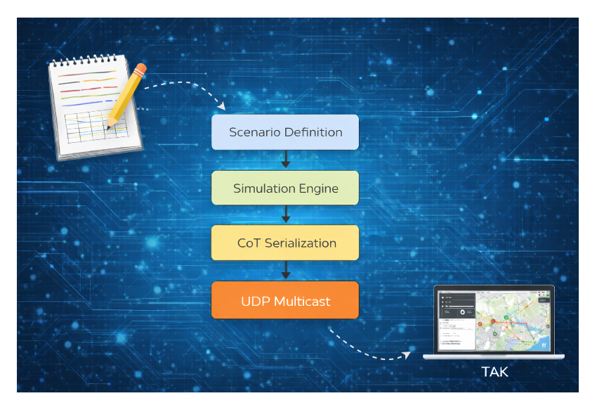
From E-Commerce to Tactical Systems
My path to Geographic Information Systems
From E-Commerce to Tactical Systems

My Path Into Geographic Information Systems
For most of my career, my work lived firmly in the commercial technology world — large-scale e-commerce platforms, highly available architectures, data pipelines, and an unwavering focus on performance, uptime, and customer experience. At the same time, I periodically consulted on and built applications for contracting companies operating in the federal ecosystem, providing early exposure to a very different set of operational constraints long before transitioning into the space full time.
The problems in e-commerce were complex, but familiar:
- Traffic spikes
- Transactional consistency
- CI/CD pipelines
- Observability
- Cost optimization
That background turned out to be far more relevant in the Federal domain than I initially expected.
My transition out of e-commerce fundamentally changed how I think about distributed systems, data fidelity, and real-time decision making. Instead of optimizing conversion funnels and checkout latency, the focus shifted to something far more consequential: maintaining shared situational awareness in complex, constrained, and unreliable operating environments.
That is where the concept of the Geographic Information Systems (GIS)— and formats like Cursor on Target (CoT) — entered my professional vocabulary.
What Is an Operational Geographic Information System (GIS)?
An operational Geographic Information System (GIS) is a shared, real-time (or near-real-time) representation of geospatial data across multiple systems, users, and domains. In practical terms, an operational GIS answers questions such as:
- What assets exist?
- Where are they located?
- What are they doing?
- Who owns or operates them?
- How recent and reliable is the data?
If you strip away domain-specific language, an operational GIS is not conceptually different from what many commercial platforms already provide:
- A logistics dashboard showing vehicles in transit
- A fraud detection map highlighting suspicious activity
- A fleet management console tracking connected IoT devices
The difference lies in constraints and consequences.
Operational GIS systems are often required to function under conditions that commercial platforms rarely face, including:
- Intermittent or nonexistent connectivity
- Extremely low latency requirements
- Heterogeneous and loosely coupled data sources
- Strict interoperability constraints
- Environments where outdated or incorrect data can have serious real-world consequences
From Shared Dashboards to Shared Situational Awareness

This is where familiar commercial patterns start to break down.
In e-commerce, we assume stable infrastructure, reliable networks, and centralized control planes. Tactical systems rarely have that luxury. Data must move quickly, expire predictably, and remain interpretable even when connectivity is degraded or completely lost.
That environment is what gave rise to Cursor on Target.
Enter Cursor on Target (CoT)
Cursor on Target is one of the foundational data formats used to represent and exchange GIS information.
It is not cutting-edge technology. By modern standards, it is even somewhat dated — but that simplicity is a feature, not a flaw.
At its core, CoT is an XML-based event schema designed to communicate:
- Position (latitude, longitude, altitude)
- Time (event time, stale/expiration time)
- Identity and affiliation
- Type of entity (aircraft, vehicle, unit, sensor, base, etc.)
- Optional metadata (speed, heading, callsigns, track quality)
A minimal CoT message looks like this:
<event version="2.0"
       uid="AIR-01"
       type="a-f-A"
       how="m-g"
       time="2026-01-08T21:15:30.000Z"
       start="2026-01-08T21:15:30.000Z"
       stale="2026-01-08T21:15:40.000Z">
  <point lat="-3.041592664217039" lon="-62.72539940833096" hae="914.4" ce="25.0" le="10.0"/>
  <detail>
    <contact callsign="AIR-01"/>
    <track course="135.0" speed="230.0"/>
  </detail>
</event>
CoT messages are intentionally small, human-readable, and transport-agnostic.
They are commonly sent over:
- UDP multicast
- TCP streams
- Message brokers
- File replay systems
This design enables CoT to function across laptops, tactical radios, servers, edge clusters, and disconnected enclaves.
From a software architecture perspective, CoT feels refreshingly pragmatic: no heavy schema negotiation, no rigid service contracts — just structured events that can be created, forwarded, fused, and expired.
Why CoT Exists (and Why It Endures)
CoT exists because the tactical environment punishes centralized, tightly coupled systems.
In e-commerce, we tend to assume:
- Stable networks
- Cloud elasticity
- Centralized observability
- Reliable DNS and PKI
In tactical systems, those assumptions often collapse.
CoT was built to survive when:
- Nodes disappear without warning
- Networks partition unpredictably
- Systems from different vendors must interoperate immediately
- Data relevance decays rapidly
One of the most elegant aspects of CoT is its time-based truth model. Every message includes a stale timestamp, meaning the data self-invalidates if it is not refreshed.
This prevents outdated tracks from lingering and misleading operators — a subtle but critical design choice.
Viewing Cursor on Target (CoT) in Practice

One of the most useful aspects of Cursor on Target is that it is not tied to proprietary or classified software.
There are multiple free, publicly available applications capable of ingesting and displaying CoT messages in real time. This is by design — CoT was created to maximize interoperability, not vendor lock-in.
These tools are commonly used for development, testing, training, humanitarian response, and operational experimentation.
ATAK (Android Team Awareness Kit)
ATAK is the most widely used CoT-capable client and is available in both government and civilian variants.
- Platform: Android
- Cost: Free
- Supports: Live CoT ingestion, multicast/unicast, TAK servers, plugins
ATAK is often the first place engineers see CoT “come alive.” When a CoT event is transmitted, assets immediately appear on the map, update in real time, and disappear automatically once their stale time expires.
WinTAK (Windows Team Awareness Kit)
WinTAK is the Windows desktop counterpart to ATAK and is ideal for lab environments, command posts, and development work.
- Platform: Windows
- Cost: Free
- Supports: CoT over UDP/TCP, TAK servers, large-screen GIS displays
WinTAK is particularly useful when running CoT simulators locally. Developers can generate CoT messages from a script or container and immediately validate behavior visually without additional infrastructure.
iTAK (iOS Team Awareness Kit)
iTAK brings CoT visualization to iOS devices such as iPhones and iPads.
- Platform: iOS
- Cost: Free
- Supports: CoT ingestion, TAK servers, mobile GIS views
While more limited than ATAK or WinTAK, iTAK demonstrates how CoT scales down to mobile, edge-operated devices. It is especially useful for understanding how GISs function in bandwidth-constrained or field-forward scenarios.
TAK Servers (Open Source and Free)
To aggregate and relay CoT messages, many users deploy a TAK server. Several free and open-source options exist.
Common capabilities include:
- CoT fan-out to multiple clients
- Authentication and access control
- Persistent track storage
- Federation between servers
Running a TAK server locally allows multiple ATAK, WinTAK, and iTAK clients to share the same GIS Picture.
Is CoT Classified or Confidential?
This is one of the most common — and most important — questions.
The CoT data format itself is not classified.
Cursor on Target is:
- Publicly documented
- Widely implemented
- Used by civilian, first-responder, and volunteer organizations
- Implemented in open-source software such as ATAK and TAK servers
The specification and schema are unclassified and publicly available.
What can be classified or sensitive is:
- The data carried inside CoT messages
- The operational context
- The network transporting the messages
- The fusion logic applied downstream
In other words, CoT is analogous to HTTP:
- HTTP is public and open
- The content sent over it may be sensitive, regulated, or classified
This openness is intentional and strategic. It enables interoperability across:
- Hobbyist
- Federal, state, and local agencies
- Civil and humanitarian organizations
CoT’s widespread adoption is precisely because it is open, simple, and extensible.
Why My E-Commerce Background Mattered More Than I Expected
What surprised me most during this transition was how transferable commercial engineering skills turned out to be.
Concepts like:
- Event-driven architectures
- Stateless message processing
- Horizontal scaling
- Schema evolution
- Observability and replayability
map directly onto GIS and CoT-based systems.
The difference is not the technology — it is the operational envelope. Building systems that must function when disconnected, under bandwidth constraints, and in adversarial environments forces a level of architectural discipline that many commercial systems never require.
In many ways, CoT represents a distilled form of distributed systems thinking — one that prioritizes survivability over elegance and interoperability over purity.
Why I Built a Simulator and Started Writing About It
As I began working deeper in this space, I noticed a gap: while CoT is widely used, it is poorly explained outside of niche communities.
Many engineers encounter it only after being dropped into a program with little conceptual onboarding.
That gap is what motivated me to start building:
- A CoT simulator
- Synthetic scenario generators
- Repeatable test environments
- Educational write-ups like this one
My goal is to show developers that the same technologies and fundamental principles apply across domains — whether you’re a hobbyist, working in commercial tech, or operating in federal environments.
What’s required is not a new skill set, but a shift in mental models.
For GIS tools specifically, if you understand event-driven systems, you are already closer to this world than you think.
What’s Next
Some ideas for articles to follow (don’t hold me to this):
- How the CoT simulator I’ve built is structured
- How assets are created, moved, and expired
- How multiple domains (air, ground, space) are represented
- How I took the simulator and deployed it as a web application
#gis #cursorontarget #situationalawareness #tak #devsecops
메타데이터
- post_id
- 2e58cea3ee19
- slug
- from-e-commerce-to-tactical-systems-2e58cea3ee19
- url
- https://medium.com/@vince.paterno/from-e-commerce-to-tactical-systems-2e58cea3ee19
- canonical_url
- https://medium.com/@vince.paterno/from-e-commerce-to-tactical-systems-2e58cea3ee19
- author_url
- https://medium.com/@vince.paterno
- status
- ok
- fetched_at
- 2026-06-16 19:09:56