Atlantis: Myth, memory, or a lost place hiding in plain sight?
Was Atlantis a myth, a distorted memory, or something in between? Plato gives us the story, but the Earth may still hold the clues we need.
Atlantis: Myth, memory, or a lost place hiding in plain sight?
Was Atlantis a myth, a distorted memory, or something in between? Plato gives us the story, but the Earth may still hold the clues we need.

The story begins with Plato, not with modern fantasy
Atlantis is one of those ideas that has become almost too famous for its own good. Long before it became a subject for documentaries, speculative maps, internet theories and lost-civilization debates, it appeared in two ancient Greek dialogues by Plato: *Timaeus and [Critias](https://www.gutenberg.org/files/1571/1571-h/1571-h.htm)*.
That matters, because any serious discussion of Atlantis has to begin there, not with later legends, occult interpretations or modern reconstructions. Plato is the source that gives Atlantis its literary shape, its moral meaning and most of the geographical details people still argue about today.
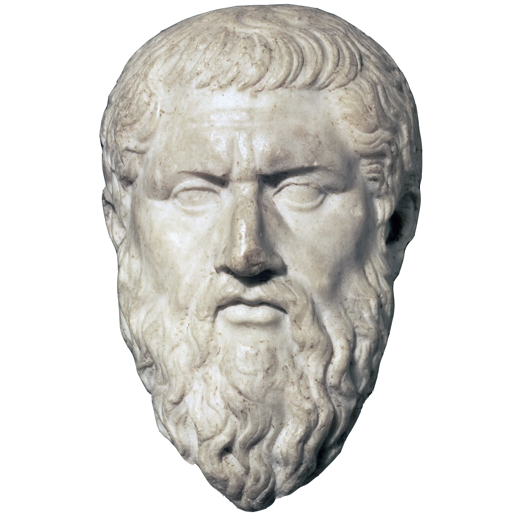
Plato is the original literary source for Atlantis. The story appears in Timaeus and Critias, where it is framed as an ancient account passed down from Egyptian priests to Solon. Credit: Creative Commons CC0 1.0 Universal Public Domain Dedication.
In Timaeus, the story is introduced through Critias, who says he heard it as an old family tradition. According to this chain of transmission, the Athenian lawgiver Solon had learned the story in Egypt from priests at Sais, who claimed to possess records older than anything preserved by the Greeks. This is the famous moment where the Egyptian priest tells Solon that the Greeks are “always children,” because their memory of the deep past has repeatedly been erased by floods, fires and other disasters. Whether this is history, literary framing or a mixture of both, it gives the Atlantis story its unusual depth: Plato does not present it as a simple myth invented on the spot, but as an ancient memory passed through Egypt, Solon, and then several generations before reaching Critias.
Critias then expands the account. Here Atlantis is described as a powerful island realm beyond the Pillars of Heracles. Its central city is arranged in concentric rings of land and water, with canals, harbors, temples, palaces, bridges, walls and an impressive plain around it. The Atlanteans are wealthy, organized and militarily strong. They possess metals, fertile lands, animals, elephants, timber, fruit and springs of both hot and cold water. But they also become corrupt, expansionist and morally unbalanced. In Plato’s telling, Atlantis is not destroyed merely because it exists, but because it declines. Its fall is both geological and ethical: earthquakes and floods erase it in a single terrible day and night, while its story survives as a warning about power, pride and forgetting.
What Plato actually says, and what he does not say
A careful reading of Plato is important because Atlantis has often been inflated far beyond the text. Plato does not describe flying machines, crystal energy systems, global technology or a science-fiction civilization. He describes a rich, powerful, maritime kingdom with impressive engineering, abundant resources and a central city laid out in rings. That is already extraordinary enough, but it is not the same as the later fantasy version of Atlantis that appears in much modern popular culture.
The most important geographical details are relatively clear, though not always easy to interpret. Atlantis is said to lie “beyond” or “in front of” the Pillars of Heracles. It is associated with a larger island or landmass, a plain, mountains to the north, rivers, fertile land, elephants, metals, and a capital city built around alternating rings of land and water. The central city is said to have three rings of water and two rings of land, with a canal connecting the ringed center to the sea. Plato also describes white, black and red stone quarried from the island, along with walls and buildings decorated with different materials.
But several details are less simple than they first appear. The word often translated as “island” does not necessarily have to mean a small isolated landmass in the modern sense, especially when dealing with ancient geography and translations across cultures. Ancient authors often used geographical language in ways that were broader than our modern categories. A place could be “island-like” if it was separated by water, rivers, marshes or a sea-route, not necessarily if it was a perfect ocean island in the middle of the Atlantic. This does not prove any alternative location, but it does remind us to be careful before forcing modern map assumptions onto an ancient text.
The destruction is also worth reading closely. Atlantis is said to sink or disappear beneath the sea, but Plato also says the area became difficult or impossible to navigate because of mud. That detail is often overlooked. A muddy, shallow, obstructed region is not the same mental image as a cleanly sunken city resting intact on the ocean floor. It could point to a memory of coastal flooding, river destruction, subsidence, tsunami deposits, marshland, or simply a symbolic image of a once-great place made unreachable. Again, it does not prove a location. But it does keep the question open.
The usual candidates: Santorini, Spain, the Azores and beyond

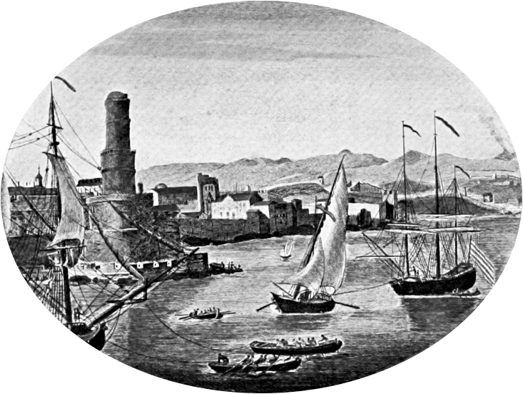
Later writers and mapmakers tried to place Atlantis in the Atlantic. Kircher’s famous 17th-century map shows how the story became part of Europe’s geographical imagination. Note that north is at bottom, via Wikimedia Commons. Public domain.
Most serious Atlantis theories fall into a few broad categories. One of the most popular is the Santorini or Thera hypothesis. Around the second millennium BCE, the volcanic eruption of Thera devastated parts of the Aegean world and may have contributed to the decline of Minoan Crete. This makes Santorini attractive because it offers a real island, a real catastrophe and a powerful Bronze Age civilization. The problem is that the timing does not match Plato’s much older date, and the geography does not match the “beyond the Pillars of Heracles” description. Supporters often argue that Plato’s chronology was symbolic, exaggerated or mistransmitted, but that requires interpretation rather than direct reading.
Another major candidate is southern Spain, especially the region near Cádiz and the Guadalquivir marshes. This has the advantage of being near the Atlantic side of the Pillars of Heracles, and the region has long been associated with Tartessos, an ancient and wealthy civilization known to Greek sources. Marshland, river systems and possible ancient coastal changes make this a more geographically grounded candidate than many others. Still, the exact ringed capital described by Plato has not been securely identified there, and no discovery has closed the case.
The Azores are another traditional candidate because they lie in the Atlantic and could be imagined as remnants of a larger lost land. But here the difficulties are significant. Plato’s Atlantis is not just remote; it is busy, fertile, politically powerful and connected to trade, armies and large populations. A mid-ocean location raises practical questions about ancient navigation, agriculture, supply and the presence of elephants and large plains. The Azores may fit the idea of a vanished Atlantic land more poetically than archaeologically.
Other proposed locations include Morocco, Malta, Sardinia, Ireland, the North Sea, the Caribbean, Antarctica and even areas that are more imaginative than historical. Each theory tends to preserve some details while sacrificing others. Santorini gives us catastrophe but not the right location. Spain gives us Atlantic proximity and ancient culture but not the ringed structure. The Azores give us oceanic mystery but not the social and ecological details. This is why Atlantis remains unresolved: the story is specific enough to invite comparison, but flexible enough to resist certainty. But one location remains, The Eye of Sahara.
Why the Eye of the Sahara is so tempting

The Richat Structure in Mauritania is a natural geological dome eroded into concentric rings. Its shape has made it one of the most discussed modern Atlantis candidates. Credit: Wikimedia Commons, NASA / International Space Station image, public domain.
The Eye of the Sahara, also known as the Richat Structure, is one of the strangest-looking geological formations on Earth. Located in Mauritania, it appears from above as a huge circular feature made of concentric rings. NASA describes it as a geological formation in the Maur Adrar Desert that resembles an impact crater but is now understood as an eroded dome, where layers of rock have been exposed in an onion-like pattern over time. In modern geology, it is not treated as the ruin of a city. It is a natural structure. That point has to be stated clearly.
And yet, as a possible Atlantis candidate, it is difficult to ignore. The visual match with Plato’s ringed city is striking. Plato describes alternating rings of land and water; Richat gives us a natural circular formation that could, in a wetter period, theoretically have held or channeled water in ways we cannot judge from the dry landscape alone. Plato describes mountains to the north; the broader region has highlands and the Atlas system farther north. Plato describes a large plain; the surrounding Saharan landscape certainly provides vast open terrain. Plato mentions red, white and black stone, and this is one of the more intriguing details when compared with the Richat region. The structure is geologically varied, with both sedimentary and igneous rocks exposed in and around the rings. Light-colored limestone, dolomite, quartz-rich sandstone and siliceous breccia may help explain the “white” element; reddish sandstone and oxidized sedimentary layers could correspond to the “red”; while darker igneous rocks such as gabbroic intrusions, basaltic material, kimberlitic intrusions and other volcanic rocks may offer a possible match for the “black” stone. This does not prove that Richat was Atlantis, but it does make the comparison more interesting, because Plato’s color detail is unusually specific.
Plato describes animals, fertile land and water; the Sahara was not always the desert we know today. This last point is crucial. The Sahara has gone through Green Sahara periods, when much of North Africa was wetter, greener and more connected by rivers, lakes and habitable corridors. Scientific studies of these humid phases show that the region could change dramatically over thousands of years, creating conditions that supported animals, human movement and settlement. There is also evidence for ancient river systems across the Sahara, including the Tamanrasset palaeoriver system, which may once have carried water across western North Africa toward the Atlantic. This does not prove Atlantis was there. But it makes it less absurd to imagine that a now-dry region once held rivers, lakes, people and ecological abundance.
The strongest version of the Richat theory is therefore not that the structure itself is “man-made.” That claim is weak and unnecessary. The stronger argument is that a natural ringed formation may have been used, modified, inhabited, remembered or mythologized by people during a wetter period of North African history. Humans have always built around natural advantages: cliffs, harbors, river bends, volcanic islands, hilltops and defensive formations. If a population had found a ringed, water-connected landscape in a green Sahara, it is not impossible that it would have become symbolically or strategically important.
Where the Richat theory becomes interesting, and where it becomes fragile
The Richat theory becomes genuinely interesting when several lines of comparison are placed together: the rings, the surrounding plain, the possibility of ancient water systems, the Green Sahara, the Atlantic-facing position of Mauritania, ancient North African peoples, rock art, and the broader idea that Plato’s “island” may not have meant an isolated ocean island. Taken individually, none of these details proves much. Taken together, they create a pattern strong enough to deserve discussion.
But this is also where we must be disciplined. There is currently no accepted archaeological evidence showing that the Richat Structure was the capital of Atlantis. No inscription has been found saying so. No city plan matching Plato’s description has been excavated. No datable ruins have been securely tied to a destroyed Atlantean civilization. The structure itself is geological, not architectural. Some claims made online go much further than the evidence allows, especially when they turn every salt deposit, erosion line or old map into proof. That is not necessary. A better argument is not “this proves Atlantis,” but “this location fits enough unusual details to be worth examining carefully.”
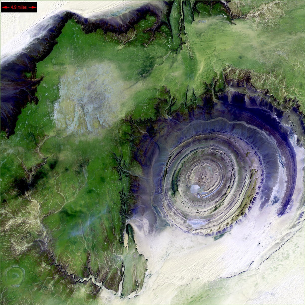
Satellite imagery shows the scale of the Richat Structure. At nearly 50 kilometers across, it is much larger than a normal city, which is one reason the Atlantis comparison remains controversial.. Credit: Landsat 7, USGS, NASA
One of the most tempting details is water. If the Richat area once interacted with rivers, lakes or coastal systems, then the old dry rings might represent something very different from what they appear to be today. The surrounding Sahara contains signs of ancient hydrology, and the African Humid Period reminds us that North Africa was certainly much wetter, greener and more habitable during parts of the Holocene. However, connecting that directly to Plato’s date and to a specific catastrophic destruction is difficult. Geological events, climate transitions, human migrations and oral memories can overlap without being the same event.
The phrase “Pillars of Heracles” also deserves more care than it often receives. Today it is usually treated as a simple synonym for Gibraltar, but in the ancient imagination it was first of all a gateway, a boundary-marker and a passage into the far western world. Even in the traditional interpretation, one of the two pillars belonged to Africa: the southern pillar was commonly associated with the North African side of the strait, often identified with Jebel Musa in Morocco or Monte Hacho near Ceuta. That already makes the phrase more African than many modern readers assume.
There are also more speculative North African interpretations. Some writers have argued that older “Pillars of Heracles” traditions may once have referred to gateways into inland seas, lake systems or water passages in North Africa, especially around the ancient Lake Tritonis tradition and the chott regions of modern Tunisia and Algeria. This cannot be treated as proven, and it should not be used as if Plato clearly meant a Saharan lake entrance. But it is still relevant because it shows that ancient geographical language was not always a fixed coordinate on a modern map. A “pillar” could mark a limit, a sacred threshold, a navigational gate or a remembered passage into a western water-world.
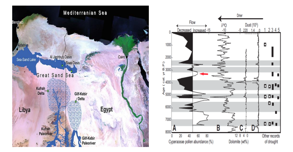
This image shows evidence for older water systems in North Africa. The left panel illustrates palaeoriver systems and groundwater-rich areas between the Major Syrtis region and the Siwa Oasis, while the right panel shows changing lake-water flow over time, with increased water flow around 1300 BC. The figure supports the broader point that parts of North Africa once contained far more lakes, rivers, wadis and wet corridors than the modern desert landscape suggests. Credit: Papamarinopoulos et al. (2023), CC BY 4.0. Figure includes material after Ghoneim & El-Baz (2020) and Bernhardt et al. (2012).
This matters for the Richat hypothesis because Plato’s phrase does not have to be reduced too quickly to one modern point on the map. It may still point broadly toward the Atlantic-facing and North African edge of the ancient world, where older names such as Atlas, Atlantes and Atlantic lands already belonged to Greek geographical memory. That does not prove that Richat was Atlantis. But it weakens the common objection that Atlantis must be placed only in the open Atlantic Ocean simply because Plato mentions the Pillars of Heracles.
For me, the Richat Structure is the most compelling candidate not because it solves every problem, but because it brings an unusual combination of details into the same landscape. It offers a ringed formation, a vast plain, a plausible North African context, a connection to the Atlantic-facing side of the ancient world, and a region that was certainly much wetter, greener and more habitable during the African Humid Period. Its weakness is equally clear: the missing archaeology. Until that changes, it remains a hypothesis, not a discovery.
Atlantis may be less about a lost city than a lost memory
The most reasonable position may be that Atlantis is neither pure fantasy nor straightforward history. It may be a layered memory: part political allegory, part ancient geography, part disaster story, part inherited tradition, and part philosophical warning. Plato was not writing archaeology. He was writing philosophy. But philosophy in the ancient world often used inherited stories, sacred geography and collective memory as raw material. A story can be shaped for moral purposes and still preserve fragments of something older.
This is where Atlantis becomes more interesting than the question “was it real?” If it was entirely fictional, then it remains one of the most powerful myths in Western literature, a story about civilization, arrogance and collapse. If it was based on a real place, then it may represent a rare ancient memory of a vanished landscape, transmitted through cultures that understood time differently from us. And if it is somewhere between the two, then Atlantis becomes a reminder that human memory is fragile, especially when coastlines drown, climates shift, languages disappear and civilizations leave behind only broken traces.
The Richat Structure does not give us Atlantis in any final sense. It gives us a question. Could a natural geological formation in a once-greener Sahara have inspired, preserved or later attracted a memory like the one Plato recorded? Could an ancient North African landscape have been misunderstood through Greek categories of island, sea and empire? Could a real disaster, or a series of disasters, have been compressed into a single dramatic story of one day and night? These are not unreasonable questions, as long as we keep them as questions.
So is Atlantis myth or real? Perhaps the answer is that it is a myth with a memory inside it. Plato’s Atlantis may not be a map we can follow directly, but it may still point toward something humanity has repeatedly experienced: the loss of worlds that once seemed permanent. Drowned coasts, dried rivers, vanished languages, collapsed societies and forgotten landscapes are not fantasies. They are part of human history. The Eye of the Sahara may or may not be Atlantis, but it forces us to look again at a region many people wrongly imagine as timeless desert. In that sense, the search for Atlantis is really a search for the parts of the human past that did not survive clearly enough to become history, but survived powerfully enough to become legend.
메타데이터
- post_id
- 4f83f13a3acb
- slug
- atlantis-myth-memory-or-a-lost-place-hiding-in-plain-sight-4f83f13a3acb
- url
- https://medium.com/the-idea-of-reality/atlantis-myth-memory-or-a-lost-place-hiding-in-plain-sight-4f83f13a3acb
- canonical_url
- https://medium.com/the-idea-of-reality/atlantis-myth-memory-or-a-lost-place-hiding-in-plain-sight-4f83f13a3acb
- author_url
- https://medium.com/@steen_m_n
- status
- ok
- fetched_at
- 2026-07-13 06:23:13