Online GPX Editor
A Complete Technical Guide to Precise GPX Editing
Online GPX Editor
A Complete Technical Guide to Precise GPX Editing
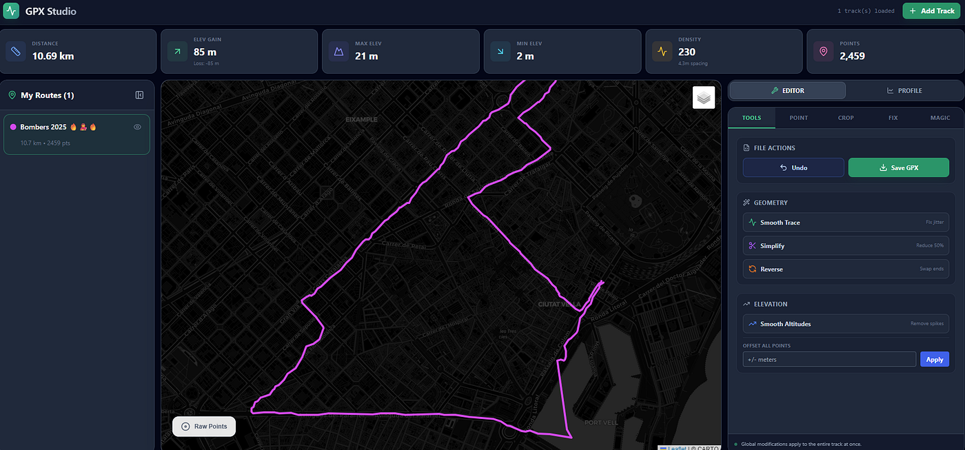
Most GPX editors let you crop a route or draw a few points. GPX Master Pro works at a different scale. It treats every track as a sequence of four-dimensional measurements — latitude, longitude, elevation, and time — and gives you precise control over each one.
TRI IT HERE: *https://gpx-master.vercel.app/*
This article covers everything the editor can do, how each tool behaves internally, and why these operations matter when cleaning or repairing a GPS track.
1. Single-Point Editing: Full Control Over Each Measurement
Every point in a GPX file is handled as:
- Latitude
- Longitude
- Elevation
- Timestamp
When you change one value, the software instantly recalculates distances, gradients, elevation deltas, speed, and moving time. Nothing is cached; everything updates in real time.
Direct numeric editing
You can type new values for any coordinate or elevation. The app validates bounds and then recalculates:
- Distance to neighbours (Haversine)
- Elevation gain/loss
- Local gradient
- Instant speed
- Segment timing

Anchor points
Anchors are protected reference points. They:
- Cannot be smoothed
- Cannot be deleted by FIX or Magic
- Cannot be moved automatically
- Survive any simplification
They’re ideal for trail junctions, sharp turns, key altitude references, or exact start/finish markers.

Dragging a point
Dragging moves the point on the map and updates the raw 4D vector. After the move, the editor recomputes all dependent metrics and updates:
- Track line
- Point markers
- Elevation graph
- Gradient and spacing visualization

Insert point (LERP)
Insertion uses 4D linear interpolation:
P(t) = P0 + t · (P1 – P0)The app generates a ghost point you can adjust before committing.

Delete point
Deleting a point removes it from the internal array and triggers a full recalculation:
- Total distance
- Cumulative ascent/descent
- Gradient distribution
- Pace and moving time
- Local spacing and density
2. Batch Editing: Multi-Point Tools for Large-Scale Fixes
Selections allow vectorized operations across hundreds or thousands of points.
Smoothing
Used to reduce jitter while keeping geometry intact.
Geometry smoothing
Kernel:
[1, 2, 1] / 4Applied to latitude and longitude.
Elevation smoothing
Five-point moving average to clean barometric noise.
Passes available
- Soft (1 pass)
- Strong (5 passes)
- Ultra (20 passes)
More passes = more blending.


Fill gaps (densify)
The tool calculates ideal point spacing:
TargetSpacing = TotalDistance / TotalPointsIf two points exceed this spacing, it inserts interpolated 4D points until the segment meets the target density.


Reduce / simplify
Removes every N-th point (default N = 2). This reduces file size without distorting the route. Anchors remain untouched.


Batch delete
Clears the entire selection. Undo history stores up to 20 steps.

3. Crop & Trim
Cropping uses range sliders instead of point selection.
Everything outside the chosen segment is removed. After trimming, the app recomputes:
- Distance
- Elevation gain/loss
- Gradient distribution
- Moving time
- Point density
Ideal for removing warm-up, cooldown, or stray loops.

4. Elevation Editing Tools
Elevation is often the most inconsistent part of a GPX track. The editor provides three ways to fix it.

Smooth altitude
Five-point averaging removes abrupt spikes caused by pressure drift or sensor noise.
Offset all altitudes
Adds or subtracts a constant elevation from every point — useful when a device starts from a wrong baseline.
Manual elevation adjustment
Precise editing of individual points whenever automatic smoothing is not enough.
5. FIX Tab: Detecting Physics Errors
This tab scans the entire track for events that violate normal movement patterns.
It detects:
- Speed spikes (above user-defined threshold)
- Elevation jumps that make no physical sense
- Teleportation gaps where distance jumps suddenly
- Cross-track deviations (XTE)
The cross-track error formula used is:
XTE = asin(sin(D13/R) · sin(B123)) · R(Where D13 is distance from point 1 to 3, and B123 is the bearing difference.)
The interface lists each flagged point, lets you jump directly to its position on the map, and delete individual or grouped anomalies. Anchors remain untouched.

6. MAGIC — Iterative Smart Restoration
Magic is the editor’s most advanced repair system. It runs in cycles (up to 50 iterations). Each cycle:
- Scans geometry, elevation, spacing, and speed.
- Detects anomalies.
- Applies the appropriate correction.
- Recomputes all metrics.
- Checks whether new errors appear after the fix.
How Magic fixes points
- Spikes: repositioned onto the line between neighbours.
- Jitter: slightly smoothed.
- Large gaps: interpolated using 4D LERP.
- Clusters of noise: simplified and stabilized.
Magic keeps running until the track converges or the iteration limit is reached.
Anchors are untouchable throughout the process.

7. Core Algorithms Used by the Editor
Haversinistance
a = sin²(Δφ/2) + cos φ1 · cos φ2 · sin²(Δλ/2)
c = 2 · atan2(√a, √(1−a))
d = R · c
Gradient
Gradient (%) = (ΔEle / ΔDist) × 100Speed and moving time
Only intervals with speeds between 1 and 120 km/h count as moving.
Linear interpolation
Used in insertion, densification, and gap repair:
P(t) = P_start + t · (P_end − P_start)8. What Happens Internally After Any Edit
Regardless of which tool you use, the chain is always:
- Points updated (drag, delete, smooth, trim, Magic, etc.)
- Distances recalculated
- Elevation deltas recalculated
- Gradient computed
- Speed and moving time recomputed
- Density and spacing updated
- Map + elevation chart refreshed
- Undo/redo state saved
- Export regenerates clean GPX XML
9. Anchor Logic
Anchors stay fixed across:
- Smoothing
- Simplification
- FIX deletions
- Magic corrections
They define the “skeleton” of the route and guarantee that aggressive cleaning won’t damage key segments.
10. Useful Interaction Patterns
- Click → select point
- Shift + click → select range
- Ctrl/Cmd + click → multi-select
- Enter → confirm numeric edits
Combining selections with smoothing or Magic lets you repair only the noisy parts of a track while leaving the rest untouched.
Closing Note
GPX Master Pro is built like a data editor, not a map toy. Every tool is grounded in geometry, distance metrics, interpolation, time deltas, and physics constraints. The result is a track that behaves like real movement: clean geometry, stable elevation, and consistent speed.
TRI IT HERE: https://gpx-master.vercel.app/
메타데이터
- post_id
- 55f4103f013e
- slug
- gpx-master-pro-55f4103f013e
- url
- https://blog.gopenai.com/gpx-master-pro-55f4103f013e
- canonical_url
- https://blog.gopenai.com/gpx-master-pro-55f4103f013e
- author_url
- https://medium.com/@alex.gascon1999
- status
- ok
- fetched_at
- 2026-06-12 22:02:08