Sofia Santos OSINT Exercise #016 (Report)
Brrrt: The sound a Thunderbolt II makes when firing the main gun.
Sofia Santos OSINT Exercise #016 (Report)
Executive Summary
The picture was taken 31 May, 2017 by Staff Sgt. Michael Battles. The river bed shown below the A-10 Thunderbolt II is about 6 km south-southwest of the small settlement Yeniköy in the Adıyaman region of Turkey. The fighter jet was supposedly flying support missions in Operation Inherent Resolve which is United States military’s operational name for the international war against the Islamic State (IS)
Introduction
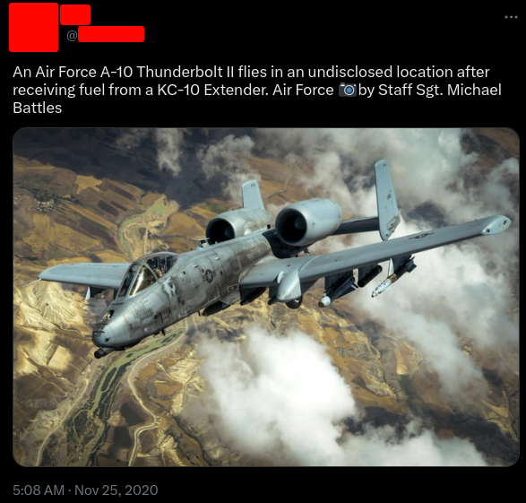
On November 25, 2020, a Twitter user shared the photo below. It depicted a military aircraft flying over an “undisclosed location”. Your task is to disclose that location.
Methodology
For this exercise I used Twitter Advanced Search, Google Earth, Maps, Lens and Search. Sources used was Wikipedia, [Defence Visual Information Distribution Service (DVIDS)](http://Visual Information Distribution Service (DVIDS)) and Jeni Kirby History at getarchive.net.
Findings
Original post
The Twitter post above was posted 25 November 2020 by the account @kadonkey:

Unredacted post
The name of the photographer was already known, Staff Sgt. Michael Battles. I performed a reverse image search and found the photo at jenikirbyhistory.getarchive.net, which in turn linked to DVIDS. The byline reads:
A U.S. Air Force A-10 Thunderbolt II departs after receiving fuel from a 908th Expeditionary Air Refueling Squadron KC-10 Extender during a flight in support of Operation Inherent Resolve May 31, 2017.The aircraft can loiter near battle areas for extended periods of time and operate in low ceiling and visibility conditions. The wide combat radius and short takeoff and landing capability permit operations in and out of locations near front lines. (U.S. Air Force photo by Staff Sgt. Michael Battles)
Operation Inherent Resolve (OIR) is the US military’s operational name for the international war against IS.
Fuselage comparison
At DVIDS I found another six photos of A-10 Thunderbolts taken at the same date, where one was taken at almost the exact same time by another photographer, Senior Airman Preston Webb. The resolution was too poor to be able to establish if it was the same identification number, but other features on the fuselage lined up.

Fuselage feature comparison
Another five photos
The first photo to mention is the photo below which probably show the same air plane as the one above. The fuselage features appears to be the same.

Same A-10 Thunderbolt as depicted above https://www.dvidshub.net/image/3441689/kc-10s-fueling-oir-fight
The other four either lacked some features or was depicted at an angle making it impossible to compare the fuselage features.

A-10 Thunderbolt II https://www.dvidshub.net/image/3373725/340th-ears-fuels-fight

A-10 Thunderbolt II https://www.dvidshub.net/image/3441676/kc-10s-fueling-oir-fight

A-10 Thunderbolt II https://www.dvidshub.net/image/3441683/kc-10s-fueling-oir-fight

A-10 Thunderbolt II (https://www.dvidshub.net/image/3441690/kc-10s-fueling-oir-fight)
Data Analysis
In the byline for Senior Airman Preston Webb photo, it is stated that the location is undisclosed, but somewhere in southwest Asia.
One of the photos on https://jenikirbyhistory.getarchive.net has two tags that is quite interesting. #qatar and #auab. Searching for auab reveals that it stands for Al Udeid Air Base outside Doha, Qatar. Qatar has bilateral relations with USA and is considered an ally. Even if an air refuel can be performed anywhere, the soil on the ground seems to be a bit too fertile to be Qatar. It was mentioned in the byline that it was taken during Operation Inherent Resolve, which could mean that the pictures were taken in Syria.
Probable flight paths from Qatar to Syria would include Saudi Arabia and Jordan, both considered USA allies and with bilateral relations.
Checking for any strike missions performed by USAF on 31 May I find information from US Central Command that there were strike missions in both Syria and Iraq.
Geolocation Analysis
Searching for “ISIS 2017 locations” gives me a link to the “Institute for the study of war (ISW)” that has a map from 10 May 2017 showing the areas controlled by ISIS.

Map as PDF from ISW showing areas in Syria controlled by ISIS
On the map above, the large body of water southeast of Raqqa looks somewhat promising. I tried a reverse image search on a part of the photo with the A-10 over water which was the most prominent part of the discovered pictures.

Turns out that the peninsula hosts the settlement called Eskihüsnümansur, (37.691135, 38.347153) located in the Adıyaman region in Turkey, 86 km (54 miles) north of the city Kobane on the Turkish-Syrian border.

All or most of the discovered photos are now expected to have been taken in Turkey.
Another photo with a prominent feature is the one showing a refuelling Thunderbolt II over a river. When zooming out on Google maps there’s one river that stands out, Eufrat.
A-10 Thunderbolt II over the river Eufrat

The river Eufrat
The above part of Eufrat matches the on under the A-10. This part of Eufrat is 48 km southwest of Eskihüsnümansur.
Next picture is showing a city in the top left and what could be maybe tunnel or road system in the top right. There seems to be a river bed running beneath the air craft.

One part of the lake runs more or less straight north from Eskihüsnümansur. It ends in a river bed that continues north. The river splits and both branches seems to have some kind of water staircase system ending in a dam. The roads surrounding it corresponds with the picture below. The dam is 9 km (5,5 miles) north of Eskihüsnümansur.

Since the last two pictures is deemed to show the same location, I focused on the exercise photo. Having established three other locations, I tried my luck between the most outer ones, the dam and the Eufrat.

Overview of the area
The river to the west of the road D875 looks promising due to it’s size. The river on the photo is not as large as Eufrat, which runs from east to west in the bottom of the above picture. Starting at the Eufrat offshoot, I work my way north. The “island” soon appears. But it looks off from the original photo and the roads are not running the same way. An 180 rotation of the map takes care of that. The air craft is flying south-southwest and the little island right below the gatling gun is located at 37.658192, 38.095537

Original picture with corresponding geographical features

Satellite photo from Google Earth with corresponding geographical features
The overview is now more or less complete. The rest of the photos will not be geolocated.

Findings Summary
Key findings in this exercise was the following:
- The other six photos. Without them, it would have been tedious..
- The Eskihüsnümansur settlement
- Establishing the area
Conclusion
I’m getting better at this!
Exercise reflections
Being bit of a air force nerd growing up, this was a fun exercise! I tried to better myself at taking notes on the go and it went fairly well. I installed the plugin for Vortimo (system created by R T) and played around with it for a bit but I’ll need some more time to get acquainted with the work flow and actually go back and check the weblogs
This is the end of the report for Sofia Santos OSINT Exercise #016, moving on to the next one!
메타데이터
- post_id
- 65e7a2e962af
- slug
- sofia-santos-osint-exercise-016-report-65e7a2e962af
- url
- https://medium.com/@osinttrails/sofia-santos-osint-exercise-016-report-65e7a2e962af
- canonical_url
- https://medium.com/@osinttrails/sofia-santos-osint-exercise-016-report-65e7a2e962af
- author_url
- https://medium.com/@osinttrails
- status
- ok
- fetched_at
- 2026-06-17 08:20:12