2025 Matai’an barrier lake flood: An A to Z guide
Of typhoons and landslides: When floodwaters equating to 6,000 Olympic-sized swimming pools crashed into an Indigenous Taiwanese township
2025 Matai’an barrier lake flood: An A to Z guide
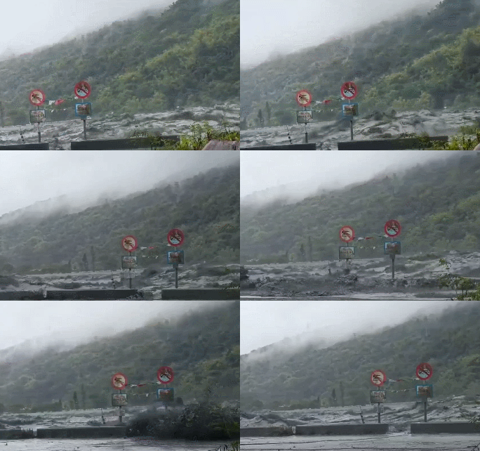


Water equating to 6,000 Olympic-sized swimming pools crashed into Hualien’s Guangfu Township on Sept. 23, 2025 after the catastrophic overflow of a landslide-triggered barrier lake. © Footage from National Dong Hwa University’s community-based resilience and response team (NDHU強韌防災團隊)
A July typhoon triggered a landslide, damming up a river to create a huge mountain lagoon, only for two more typhoons to bring additional rain to the precariously remote highlands, leading to the catastrophic overflow of the impermanent lake. The setting is Hualien in eastern Taiwan. The date is Sept. 23, 2025. At the foot of the mountain is a township called Guangfu comprising 14 villages with a total population of about 12,000.
After breaching the dam at 2:50pm, the first wave arrived at Matai’an Creek Bridge at 3:08pm, which collapsed about 20 minutes later. About 15.4 million tonnes of water, which would fill 6,000 Olympic-sized swimming pools, galloped down the mountain, slamming central Guangfu by 4pm. The murky torrents unleashed crashed into urban infrastructure, swept away cars, and flooded buildings within the first 70 minutes.
Despite evacuation efforts that started 24 hours prior — text message alerts were sent, community loudspeakers were activated, several neighborhood chiefs began knocking door by door — some residents were lulled into a false sense of security because the typhoon was already departing Taiwan, others thought the waters wouldn’t exceed a meter in height (it ended up reaching 3 meters). Several people even left the evacuation shelters when the rain stopped. By the time the muddy tsunami became visible to the eye, people had no time to escape and many drowned in their own homes.
The Matai’an barrier lake flood resulted in 20 confirmed deaths (19 flood victims and 1 volunteer). From the disaster zone, 717 were rescued, 157 injured, and 5 remain missing. Over 8,000 people encompassing 3 villages were directly impacted by this incident. In certain parts of Guangfu, the receding waters left behind sludge up to 2 meters deep. It may take up to 3 years to eco-consciously dispose of all the debris. Here are 26 anecdotes providing more context:

An aerial view of the Matai’an barrier lake on Oct. 20, now holding only 1.7% of its water capacity compared to Sept. 23 before the overflow. © Forestry and Nature Conservation Agency
A represents the Amis (阿美族), also known as the Pangcah, one of the 16 Formosan Indigenous groups recognized by the government. As a part of their traditional territory, Hualien County has the highest concentration of Amis people at 53,318 out of a total population of 231,807. The flood-damaged Guangfu Township is home to tribal communities including Alolong (阿囉隆), Atomo (阿陶模), Fata’an (馬太鞍), Fahol (馬佛), Kalotong (加里洞), Laso’ay (拉索艾), Okakay (烏卡蓋), Sado (砂荖), and Tafalong (太巴塱); the historic Tafalong in particular has been established in this part of Taiwan for over two thousand years. The Amis make up roughly half of the township’s population today.
B stands for barrier lake (堰塞湖), otherwise known as a landslide dam if created by a landslide, or a quake lake if caused by a quake. Last year’s 7.2-magnitude earthquake with its epicenter in Hualien already shook up the mountains and damaged the region’s geological integrity, so when excessive rain courtesy of Typhoon Wipha arrived in July, that triggered a landslide blockading a flushed Matai’an creek. The resulting 200-meter-tall barrier lake could hold up to 86 million cubic meters of water, the equivalent capacity of the manmade Nanhua Dam in Tainan. Moreover, before the overflow, Matai’an lake held 10 times the volume of rocks and debris than the barrier lake that buried Xiaolin Village in 2009.
C is the unmistakable mark of colonialism (殖民主義). The Amis once lived in hillside communities above the floodplains that became today’s Guangfu Township. Even the early Han settlers respected the cyclical floods that irrigated the lowlands with silt. Besides forcibly relocating the Indigenous away from their mountainous homes, Japanese colonial authorities (1895–1945) also chose to place a sugar factory here and a settlement grew from labor demand for growing and cultivating sugarcane. More settlers arrived under the Republic of China regime (since 1945).


“Kakita’an” is the Amis word for the chief’s house, where rituals were held and guests were received. Pictured above is the kakita’an that belonged to the founder of the Tafalong tribal community in Hualien. It eventually fell into disuse after a series of natural disasters; a research team from National Taiwan University purchased the carvings and main beams of the house in 1959, which are believed to be stored at Academia Sinica in Taipei. © Hualien Cultural Bureau
D denotes disaster relief (賑災). The Taiwan Foundation for Disaster Relief, a foundation established by the Executive Yuan, has received over 180,000 individual donations in the first five days after the catastrophe struck, culminating in NT$400 million going towards recovery efforts. Convenience store chains also utilized their logistic networks to transport aid to the disaster zone, with 7-Eleven working with other brands under the Uni-President conglomerate to donate bottled water, bread, instant noodles, rice balls, and tissue paper to temporary shelters across Hualien. Family Mart deployed food trucks to hand out hot food like oden stew, hotdogs, and freshly steamed buns for free.
E is short for evacuation (撤離). The central government issued Taiwan’s largest-ever evacuation order just one day before the lake burst, leading to 8,385 people relocating from danger zones. Automated cellphone alerts (text) and community loudspeakers (broadcast) were also utilized; however, such messages were delivered only in Mandarin and English, not the Indigenous languages that village elders were most fluent in. To complicate things, loudspeakers malfunctioned in some areas, meaning cop cars were deployed instead to spread the evacuation warning (a siren sequence that rings for 85 seconds). Only some community leaders doorknocked to warn the elderly.
F belongs to Fu Kun-chi (傅崐萁) and his wife Hsu Chen-wei (徐榛蔚). One was Hualien County Magistrate from 2009 to 2018, one is the current magistrate. Despite advanced typhoon warning, Hsu left on Sept. 18 for Japan and South Korea to learn from their tourism sectors, was incommunicado on Sept. 20 when the central government tried to contact her with the specific request to immediately return, was absent from the Sept. 21 emergency meeting, and only cut short her working trip after evacuations began on Sept. 22. Fu, who is now a legislator representing Hualien in the Taiwanese parliament, and Hsu both blame the central government for the disaster.


Disaster relief goods arrive in Hualien via 7-Eleven’s logistics network; flood survivors can pick up free hot food and pay their bills at Fami Mobi, a smart truck program developed by Family Mart; a convenience store sign saying “7-Eleven welcomes all shovel superheroes to come in and rest, we don’t mind the mud.” © 7-Eleven, Family Mart, 路上觀察學院
G stands for Guangfu (光復), meaning “Retrocession,” a patriotic slogan used to rename streets, communities, and villages by the Republic of China to stamp its ideology all across Taiwan. The ROC considers itself the inheritor of all the territory claimed by the Qing, the last imperial Chinese dynasty that was toppled by factions led by Dr. Sun Yat-sen. However, the Qing only ever managed to control northern Taiwan, and it was imperial Japan that forced all of Taiwan under one central authority after the Qing ceded its claims by signing the Shimonoseki treaty. In the aftermath of World War II, Taiwan became a ROC colony. Hualien’s Guangfu Township is home to both Matai’an creek and the Matai’an tribal community; the latter, comprising 6 villages, has recently been renamed Fata’an (馬太鞍, also romanized as vata’an), after the Amis word for the region’s staple crop “pigeon pea (樹豆).”
H is for Hualien (花蓮), an eastern region of Taiwan of resounding mountainous and coastal beauty. The local economy is driven by agriculture and tourism, two sectors that have been disrupted in recent years by incidents including a major train derailment in 2021 and a 7.4-magnitude earthquake in 2024. H also stands for hope, a sentiment best encapsulated by a Lin Hsin-yueh (林惺嶽) painting titled “Blessed Hualien (天佑花蓮)” on display at the Presidential Office, in which the ever-present sunlight shines unselfishly and equally on every corner of the land.
I is short for infectious diseases (感染性疾病) caused by bacteria like Leptospira and B. pseudomallei that thrive in the muddy aftermath of the flood. Contrary to misinformation warning volunteers to stay away from the disaster zone, such diseases are not transmittable between humans and are preventable by handling contaminated water or soil with gloves, wearing masks, and wading in boots. Medical stations comprising hospital employees, social workers, and volunteer medics are also on site to assist with any injuries as well as to provide services such as physical therapy, free haircuts, ice and water, and prescription medication for chronic illnesses. As of Oct. 6, over 4,740 individuals have received assistance at these stations.

An oil painting titled “Blessed Hualien” by the late Taiwanese artist Lin Hsin-yueh. It is currently on display at the Presidential Office. © “Lin Hsin-yueh: Magical Light and Shadow in Nature”
J for justice (正義), transitional justice. As Taiwan moves to codify stronger legal protection for Indigenous peoples and restore their linguistic rights, their right to use natural resources, and particularly their land rights, it should be noted that the Amis residents of Guangfu Township have expressed no desire to relocate but rather wish to rebuild their lives in ancestral territory. Prioritizing both physical and cultural safety, the preferred approach of “Moving away from danger, not away from home” means maintaining their connection to land, kinship, and ritual life. Hualien Magistrate Hsu Chen-wei, however, has already proposed relocation for the 89 households of Daping (大平村) and Datong (大同村), two smaller villages devastated by the barrier lake flood.
K serves as a reminder to be kind (善良), to others as well as yourself. The health ministry has compiled eight self-care points for the volunteers toiling under the harsh autumn sun to restore normalcy to the areas impacted by the barrier lake flood: (1) wear protection like rubber boots, plastic gloves, and masks, for flip-flops will not suffice; (2) boil drinking water and sterilize cisterns; (3) bleach items and areas covered by sludge, disinfect hands after cleaning up; (4) avoid heat strokes by wearing baggy, breathable, and light-hued clothing; (5) stay hydrated; (6) stop and rest if you have trouble stopping your heart from racing, or if your skin begins to crack or turn red; (7) prioritize mental health, acknowledge your contributions and limitations; and (8) support other volunteers and exchange experiences.
L refers to longan (龍眼), a tropical tree that produces a pitted fruit known as “dragon eyes.” A harvesting ladder left propped on the side of a house by a longan farmer became a lifeline to 20 humans and 2 street cats when flash floods came crashing. Drivers abandoned their vehicles on the road and hoisted themselves to safety by climbing the ladder to the farmer’s roof, where they were able to weather the worst of the storm and flood by hiding under a tarp.


Rubber boots are provided to volunteers who have traveled to aid with Hualien’s recovery efforts; 20 people survived the churning flood waters by climbing onto longan trees and the roof of a farmer’s house with the aid of one lone ladder absently left on the side of the building. © Liberty Times
M means mud (泥濘), a grimy presence covering the entire disaster zone, including the township’s graveyard, farmlands, and nearby train tracks. Measuring up to 2.6 meters in height on some streets, the mud and debris being cleared by shovel superheroes and military personnel are currently being stored on five plots of land loaned by the Taiwan Sugar Company as a temporary solution. It will take an estimated three years to properly dispose of it all — through recycling what’s salvageable and applying the dirt towards construction. Meanwhile, one million tonnes of sludge is turning to dust under the sun and becoming a breathing hazard.
N symbolizes nightmares (夢魘), especially those triggered by the trauma of encroaching floodwaters and the loss of one’s home or loved ones. Some children have also refused to sleep, pleading with their mothers to keep them company at night. Parents are advised to keep an eye out for indicators of post-traumatic stress like sleep disturbances, fear of loud or sudden sounds, or unusual emotional volatility. Counselors are available at the seven medical stations managed by the health ministry.
O represents open wounds (傷口) incurred by rescuers and volunteers — often caused by tree branches, rocks, rusted nails, broken glass, and other sharp objects hidden by the deep blanket of sludge covering the village. Tragically, a volunteer from Taoyuan who brought his own excavator machine, Lin Hong-sen (林鴻森), died from sepsis after ignoring an open leg wound in his urgency to aid others.


The muddy aftermath of the Matai’an barrier lake tragedy; excavator Lin Hong-sen, the first volunteer who tragically lost his life in recovery efforts. © Public Television Service, Apple Daily
P stands for possessions (財產). Writer Hawk L. Rumaling (赫恪‧魯瑪林) lost his entire collection of 30,000 books and historic documents. The sole rice factory in Guangfu lost its only rice milling machine as well as an agricultural scale among other machinery that will cost a combined NT$2 million to replace. Kuangfu Commercial and Industrial Vocational High School has its basement generators, sports fields, driving course, and auto technician tools all buried by mud, meaning its 150 students largely from low-income families will not be able to attend school for at least two months. Agricultural damage and recreational farming loss are estimated at NT$380 million (US$11.82 million). Residents were warned to not be alarmed if they see floating coffins, human remains, and burial gifts because Guangfu’s public cemetery is under water.
Q refers to the long queues (隊伍) of volunteers waiting for public transportation to get to Hualien, especially on weekends or holidays. In support of their compassion, the transportation ministry has subsidized tour bus and taxi drivers to ferry volunteers from train stations to the disaster zone for free. Contrary to misinformation claiming volunteers can waive train fares and stay at hostels without payment, the government currently has no such civilian programs, as military personnel have also been deployed to restore Hualien.
R is short for Ragasa (樺加沙), the strongest typhoon of the 2025 season. The Category 5 formation carried wind speeds of up to 269 km/h and led to 19 deaths, 5 missing individuals, 157 injured, an electricity outage affecting over 17,000 households, and an estimated NT$638 million in agricultural damage across Taiwan. The top crops affected were watermelon, soybean, wintermelon, and sorghum; tilapia and clams in terms of aquaculture. Wrecked farming equipment, submerged land and ponds, and fishing vessel damage rounded up the loss.


Tour buses and cabs offering free rides from train stations to the disaster zone for volunteers helping with recovery efforts; Typhoon Ragasa brought heavy rains and caused floods and landslides in China, Laos, Taiwan, Thailand, Vietnam, and the Philippines. © Ministry of Transportation and Communications, Global Disaster Alert and Coordination System (GDACS)
S is the universal symbol for superhero (超人), specifically “superheroes with shovels (鏟子超人),” volunteers from all across the country removing mud and debris with their own trowels; “bento superheroes (便當超人)” giving away free lunch boxes purchased with their own dime; “bulldozer superheroes (挖土機超人)” riding in on their own machinery; “ladle superheroes (勺子超人)” clearing drains; and “transporter superheroes (小蜜蜂超人)” offering free rides and transportation of goods. Notable volunteers include powerlifter Fang Hui-ling (方慧玲), supermodel Wu I-hua (吳宜樺), actor Jin Yun (金雲), and a one-arm pastor named Lin Kuo-wei (林國威). A record 400,000 volunteers, including migrant workers and foreign residents, showed up just to shovel sludge.
T is short for Tafalong a kiwkay (太巴塱教會), a Presbyterian church that has been servicing the local Amis community for 79 years. At one point housing 450 community members fleeing from the flood, the church is currently functioning as a proverbial Noah’s Ark providing reprieve from the deluge and a safe space to rest, sleep, and eat. Local emergency response meetings are also held there. Reverend Namoh Arang (那麼好.Y讓牧師) briefed Vice President Bi-khim Hsiao (蕭美琴) when she visited Tafalong Church on Sept. 24.
U calls for unplugging (疏通) street gutters, drains, pipes, plumbing, and other essential public and personal infrastructure clogged by sludge. Not everything can be cleaned with a shovel, hence the provision of over 900 metal soup ladles from the government for volunteers willing to painstakingly clear out tubular or constrained spaces. The lack of running water at many parts of the hard-hit township poses a huge sanitary challenge that is provisionally offset by mobile showers and restrooms.


Powerlifter Fang Hui-ling unloading boxes of donations; people seeking shelter and medical help at Tafalong Church; sludge being removed from congested sewers with metal ladles. © Threads user @aon620609 via Mirror Media, Premier Cho Jung-tai’s Facebook page, Formosa Television
V denotes video calls (視訊), specifically telehealth. Three days after the barrier lake collapsed, two survivors were able to receive healthcare by video-calling a doctor appointed by the health ministry and receiving their medication by drone. The first feat of its kind in Taiwan, medical drone deliveries have to meet stringent requirements including a flight distance under 10km, uninterrupted 5G coverage, a load limit of 3kg, and a wind speed below 7 on the Beaufort scale.
W refers to wedding portraits (結婚照), in which a framed one was found covered in mud by a volunteer. His glee turned into embarrassment when a local resident informed him that the photographed couple had divorced: “At that moment, all I wanted to do was bury myself and that portrait back into the ground.” Other volunteers who also found wedding photos were more fortunate, for they were able to locate the owners and take selfies with the happy couples.
X marks the place where Xiaolin Village (小林村) was buried by a landslide following a barrier lake collapse in 2009. Commemorating the 462 victims of the Typhoon Morakot-triggered tragedy, the 1.7-hectare Xiaolin (Siaolin) Memorial Park in Kaohsiung comprises 181 Formosan cherry trees representing the 181 families lost to a midnight mudslide following heavy rainfall, an ancestral hall, a bridge, a memorial square, a 9-meter-high stone monument, and a platform overlooking the buried village. Survivors were relocated to nearby communities.


A medical drone being prepped for making a delivery; a mud-encrusted wedding portrait discovered by a volunteer; aerial footage of Xiaolin Village before and after the barrier lake collapsed that wiped away the community. © Ministry of Health and Welfare, Threads user @ling.y0411 via Liberty Times, Water Resources Agency
Y is short for 168, a numeric homophone for “continuous prosperity” pronounced “Yilufa (一路發).” This was the auspicious name bestowed to a russet brown dog saved from the disaster site. The mud-splattered pup was adopted by a member of the Kaohsiung Fire Bureau’s rescue team and is now on his way to his forever home in southern Taiwan.
Z is a somber reminder that a month after the initial devastation, Guangfu and three other townships are still red alert zones (紅色警戒區). Four criteria must be met before the alert is lifted: first, when the barrier lake is no longer a threat; second, upon the erection of a tri-layered temporary embankment comprising dirt, steel mesh, and shotcrete (sprayed concrete); then the completion of artificial floodways; and after evacuation plans are finally drafted by the Hualien County government.


168 when he was first spotted, a lonesome figure traipsing through mud; his rescuer, a first responder who also adopted him; 168 on his way to his forever home. © Liberty Times, Hualien Guangfu Animal Rescue Volunteer Group (花蓮光復動物救援志工團隊)
TIMELINE
July 18–19: Typhoon Wipha brings torrential rain to mountainous areas already damaged by a series of deadly tremors that took 18 lives from Hualien last year.
July 21: Hualien incurs a 4.9-magnitude landslide that is picked up by a real-time monitoring system developed by seismologist Weian Chao (趙韋安) of National Yang Ming Chiao Tung University. This seismic activity is so unusual, given that it’s the largest of its kind to ever be recorded by the United States Geological Survey (USGS), that the American agency contacts Dr. Chao for confirmation.
July 25: After receiving notice from Dr. Chao, who is billed as the first person to discover the Matai’an barrier lake, the forestry agency confirms its existence by studying satellite imagery.
July 26: A survey team is flown in on three Black Hawk helicopters to snap aerial photos and install instruments such as water-level gauges, cameras, and microtremor sensors. The forestry agency issues emergency alert #1 informing relevant Hualien authorities of the lake’s formation.
July 28: The forestry agency issues emergency alert #2 identifying 200 households with a total estimated population of 600 people that are in harm’s way.
Aug 7: The forestry agency briefs Hualien county government on the disaster potential of the barrier lake and outlines the scope of evacuation measures required.
Aug 12–14: Matai’an lake swells with additional rainfall from Typhoon Podul and a new, albeit smaller barrier lake is formed below it, according to data provided by Formosat-5, a Taiwanese observation satellite. 259 households comprising 697 people were evacuated until Podul passed.
Aug 27: A team convened by the agricultural ministry begins working on three priorities: monitoring the barrier lake, engineering reinforcement or dismantlement plans, and developing evacuation strategies.
Sept 9: After receiving a reminder from the US Army Corps of Engineers (USACE) “to consider the most extreme outcome,” the central government forms a special task force encompassing government delegates, engineers, and university experts to map out the worst-case scenario and accompanying contingency measures — this formal report was scheduled to be released on Sept 29, containing public warnings to avoid the area and plans for evacuation rehearsals, for it was estimated that the lake would overflow in mid-October.
Sept 16: Taiwan’s Public Warning Cell Broadcast Service conducts a regional drill, only to discover that the spotty connection in certain parts of Hualien meant not all cellphone users received the emergency text message. The National Communications Council advises the addition of more cell towers and the introduction of a fail-safe plan that entails individually dialing all the landlines registered to that area. A Barrier Lake Alert is officially added to the mobile warning service as the 24th disaster alert category on Sept 19.
Sept 19: Projected impact area widens as a new typhoon looms; an inter-governmental meeting bringing together local and central officials asks the Hualien County government to compile a list of what is needed to make such an evacuation possible, and that military assistance is available upon request.
Sept 21: Activated in preparation for Typhoon Ragasa, the Central Emergency Operation Center provides Hualien and Guangfu authorities with a list of 8,524 people from 1,837 households who live in the projected impact area, reiterating that the local government can depend on the full support of the central government.
Sept 22: The forestry agency issues a red alert — the lake is now predicted to overflow within the next 48 hours. Hualien officials are tasked with completing evacuations and residents are presented with three options: relocate to a shelter on higher ground, leave the area and stay with family out of town, or retreat to the second floor of a vertical evacuation structure (a multi-level edifice not situated by the riverbanks and made of materials such as reinforced concrete that can withstand flash floods).
Sept 23: The Hualien County government confirms with the Central Emergency Operation Center that evacuations began at 9am yesterday and 167 residents have reached shelter, 3,118 left town, and 5,239 chose the vertical evacuation option by 9am today. Less than five hours later, the barrier lake begins to overflow at 2:50pm.
COMMON QUESTIONS


Comparison of the landscape pictured on June 25 versus July 25, the day the barrier lake’s existence was confirmed by satellite imagery; a photo taken on Sept. 6 with newly installed monitoring instruments; the remaining lake on Oct. 3, ten days after the cataclysmic overflow on Sept. 23. © Forestry and Nature Conservation Agency
Why wasn’t the barrier lake removed or reinforced?
Explosives and excavation proposals to blast away or deepen the dam were ruled out due to the lake’s volatile composition. With no immediate way to divert water away from the populated lands below, even if the required steel pipes with an one-meter diameter were heaved up the mountain, siphon drainage was not a feasible solution either. There are no roads to bring in heavy machinery to an unstable area with active landslides. Michael Turton writes in the Taipei Times:
Nothing could be done on the barrier dam itself because of the site’s remoteness — by government estimates nearly three years would be required to put in a 15km access road to bring in equipment. Moreover, altering the dam was considered risky given its instability and ability of water to get around or over it. The authorities thus proceeded with evacuations as the obvious response.

A Barrier Lake Alert is officially added to the mobile warning service as the 24th disaster alert category in September 2025. © Public Warning Cell Broadcast Service
Why weren’t people forcibly evacuated?
According to Taiwan’s Disaster Prevention and Protection Act, that decision belongs to the local government, not the central government. See Act 24 regarding “Measures of Emergency Refuge”:
In a case of a disaster or where there is a concern of a disaster, the municipal government, county (city) governments, or the township (city) and indigenous districts offices shall advise or force people to evacuate and provide proper settlement to protect the safety of people’s lives and properties or prevent further expansion of disaster.

Marked with a star, the landslide location was obtained from satellite imagery. © USGS National Earthquake Information Center
Why wasn’t the July 21 landslide made public?
The Central Weather Administration’s Seismological Center acknowledged that the landslide was observed but not reported because the event was not categorized as an earthquake. Therefore no public records were made available. According to satellite imagery analysis by USGS:
The landslide was about 1.5 km wide, traveled about 5 km, and formed a landslide dammed lake on the Matai’an river.
The landslide displaced 300 million cubic meters of sediment and rocks. That’s enough to fill up 2.3 Sun-Moon Lakes, making Matai’an the largest barrier lake in Taiwan’s modern history. The CWA looks to amend its protocol and make landslide data more readily available.
The formation and dangers of the Matai’an barrier lake were identified right after this landslide happened, however, and subsequent information quickly became available. Unfortunately, the official government report on how to handle the barrier lake and train for the escape plans was slated for a Sept. 29 release, six days too late, since the deadline was originally chosen upon the assumption that the lake would only be breached in mid-October.

For those considering vertical evacuation, please store water, food, first aid kits, ID, and medical records on higher floors. Buildings with corrugated metal roofs do not qualify as vertical evacuation structures. © National Science and Technology Center for Disaster Reduction
What does vertical evacuation mean?
The UNESCO’s International Tsunami Information Center says:
A vertical evacuation refuge is a structure or earthen mound designated as a place of refuge in the event of a tsunami. The refuge is designed for short-term protection (12–24 hours), has sufficient height to elevate evacuees above the tsunami inundation level, and has been designed and constructed to withstand an earthquake and resist tsunami load effects.
The idea is to retreat to a structure that has the strength and resilience necessary to resist rapidly rising waters. Contrary to disinformation, it is not a new concept in Taiwan and as far back as 2018 “vertical evacuation (垂直避難)” has been included in the Hualien disaster prevention handbook under then-Magistrate Fu Kun-chi.


Before and after photos revealing the successful removal of sludge between Oct. 3 and 9: A fleet of cement trucks unearthed in front of a pavilion next to Bao’an Temple (保安寺); a residential home on Fozu Street (佛祖街) that was originally half-sunken in mud; Buddhist Arhat statues freed after being buried for two weeks. © Threads user @jetertung via Formosa Television
What are the lessons to carry forward for Taiwan?
Perhaps vertical evacuation should not be offered as a preemptive evacuation option when there is sufficient time to leave the danger zone, but rather be considered as a last resort for those unable to escape when the flood hits. There is also discussion of setting stricter standards for what constitutes as a passable vertical refuge and how to conduct periodic checks.
Emergency alerts should take into account all the national languages of Taiwan, following current standards that dictate when public signage in different parts of the country should be offered in Mandarin Chinese, English, and additional languages that are commonly practiced by a considerable portion of the local population. In this case, the Indigenous language of the Amis community living in this portion of Hualien.
More measures should be taken to inform at-high-risk residents — such as the elderly, basement dwellers, people living with disabilities, mobility issues, or chronic illness (such as those who require dialysis), as well as those with sight or hearing challenges. Over 27% of the Guangfu population are aged 65 or above. Not all received a knock on their door to warn them of the coming danger in the Sept. 22 evacuations.
As the most grassroots unit to be elected in Taiwan, neighborhood chiefs (村/里長) are most likely to be familiar with which households include at-risk residents. Planning and rehearsing for evacuations or other disaster contingency plans should start by including them. Moreover, the Central Emergency Operation Center should have a list of evacuation specialists who can travel to the predicted impact area and provide on-site consultancy to local officials and community chiefs.
Unlike clearly defined procedures for natural disasters like earthquakes and typhoons, there are currently no standard protocols to follow when it comes to barrier lakes. This should be swiftly rectified, since barrier lakes are not uncommon in Taiwan, with 88 recorded between 1979 and 2025. Typhoon Morakot spawned at least 16 barrier lakes in 2009, one of which buckled and buried Xiaolin Village in Kaohsiung. The 7.2-magnitude quake that struck Hualien last April also formed one that disintegrated naturally without causing any harm.

Taipei 101 fireworks on National Day paid tribute to the volunteers and disaster relief workers helping with Hualien’s recovery efforts. Taiwan’s tallest building lit up with a spade emoji as drones spelled out “Taiwan, add oil!” © Taipei 101 Facebook page
Above all, thanks to all the volunteers and disaster relief workers.
As President Lai Ching-te stated in his National Day address on Oct. 10:
… The tens of thousands of volunteers who, after the Fata’an Creek barrier lake disaster, slipped on their rain boots, shouldered their shovels, and traveled great distances to provide relief to help the affected residents of Hualien return to normal life as soon as possible.
These “superheroes with shovels” did more than dig out heavy mud and sludge to help disaster victims return home; these heroes also uncovered a light — a light of hope that warmed every heart it touched. More than that, they proved the remarkable resilience of the Taiwanese people and their resolve to protect our homeland in the face of crisis.
Now, let us all thank these superheroes of disaster relief, who come from all walks of life and from all over the country, as well as friends from abroad and the military, police, firefighters, and central and local government personnel who devoted themselves to the relief effort.
This spontaneous nationwide movement is absolutely unique in the world, and for that the world will remember: Taiwan, that small mountainous country, is truly compassionate.
SEE ALSO
- Resources for volunteers and residents in Hualien
- Live feed of the Matai’an barrier lake
- Updates on the donation drive for recovery efforts
- Notes from Central Taiwan: Mataian barrier lake flood: Not entirely natural
- Gym bros, monks, retirees: thousands descend on Taiwan town to clean up after devastating flood
- Taiwan’s Barrier Lake Disaster Intersects With Its Troubled Indigenous Policy
- 還原關鍵64天:崩塌量體比小林村大10倍的馬太鞍堰塞湖怎麼發現?科研團隊如何即時監測?美國也提供資訊協助?
- 花蓮光復鄉水患重創 教會成災民避難所 家園重建漫漫需要代禱
- 讓光復成為動詞6/撤離通知只有國語和英語 原住民老人聽不懂
- 台灣事實查核中心:馬太鞍溪堰塞湖報導專區
- 公視 我們的島:潰壩之後 — 紅色警戒持續中
- 馬太鞍溪堰塞湖監測紀實:應變時間軸、監測情資與災情地圖
메타데이터
- post_id
- 6718d71fa28c
- slug
- 2025-mataian-barrier-lake-flood-an-a-to-z-guide-6718d71fa28c
- url
- https://medium.com/@wordsfromtaiwan/2025-mataian-barrier-lake-flood-an-a-to-z-guide-6718d71fa28c
- canonical_url
- https://medium.com/@wordsfromtaiwan/2025-mataian-barrier-lake-flood-an-a-to-z-guide-6718d71fa28c
- author_url
- https://medium.com/@wordsfromtaiwan
- status
- ok
- fetched_at
- 2026-08-17 07:11:18