Al-Idrisi and the World Map That Changed Geography
Mapping a World No One Had Ever Seen From Above
Al-Idrisi and the World Map That Changed Geography
Mapping a World No One Had Ever Seen From Above

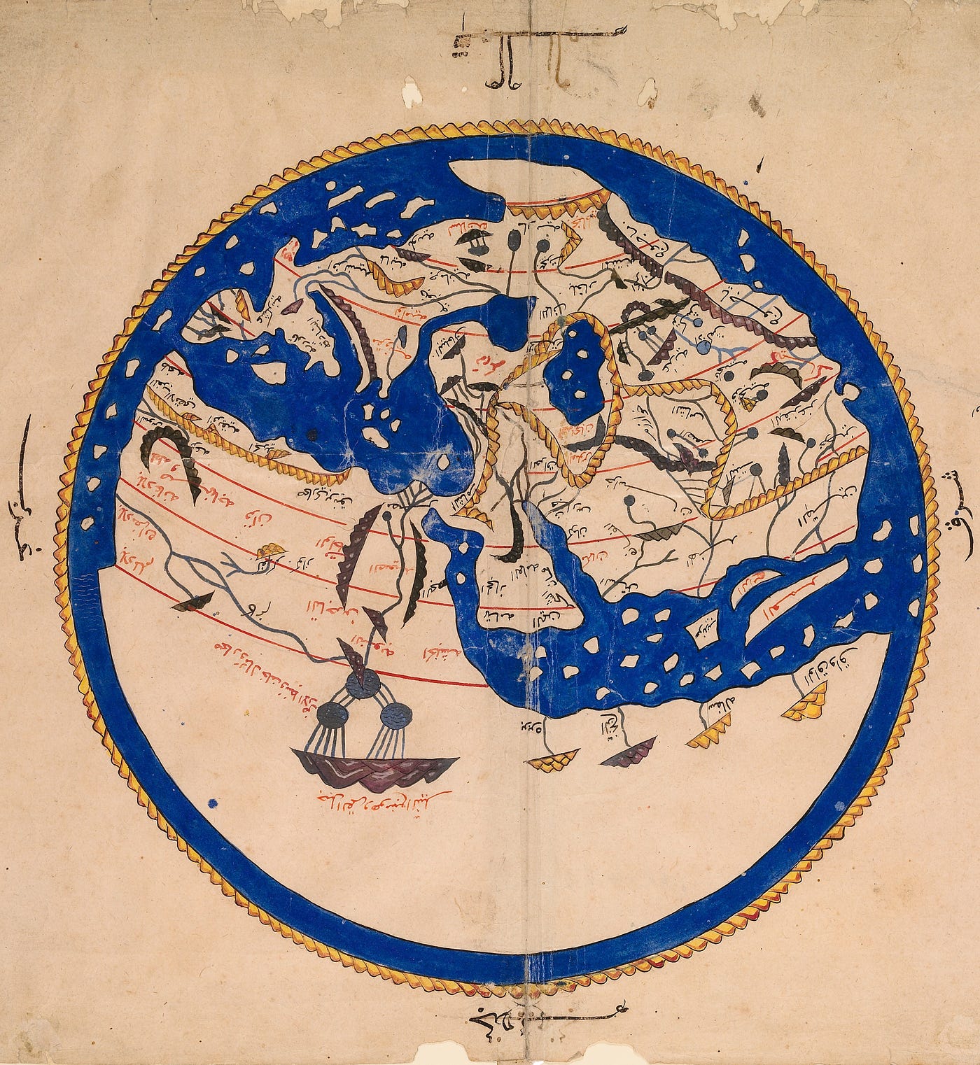
Al-Idrisi’s world map (a copy from a 16th-century manuscript). It depicts the known world, from the equator to the latitude of the Baltic Sea, and from the Atlantic to Siberia. Its cardinal directions are labeled in Arabic, with south positioned at the top of the map. Bodleian Library
Today, we can observe the Earth around the clock. But for most of human history, it was impossible to see the world from above. Yet we still had to find a way to describe it.
So for centuries, scholars, travelers, sailors, and merchants tried to piece together the known world bit by bit. And among them, one fascinating figure left behind an incomparable legacy: Al-Idrisi. A 12th-century geographer, cartographer, and botanist, he was the author of what remained for nearly 300 years the finest depiction of the known world. And frankly, it is absolutely magnificent.
A scholar from Al-Andalus
Al-Idrisi was born around 1100 into a noble family originally from the Maghreb, in Ceuta, which at the time was under the influence of the great Muslim dynasties of North Africa and Al-Andalus. In the 12th century, the Mediterranean was a vast intellectual crossroads, where the Muslim world engaged in exchange with Christian Europe, Africa, and the East. Greek knowledge circulated widely and was translated, annotated, and expanded upon. In Córdoba, where Al-Idrisi studied, debates were held on medicine, astronomy, philosophy, law, and mathematics. He was, in fact, a contemporary of the great Ibn Rushd (Averroes to the Latins), a translator and commentator on the works of Aristotle.
The Mediterranean at that time was also shaped by constant flows of goods and travelers. And Al-Idrisi travelled a great deal. He journeyed through the Maghreb and Al-Andalus, and is believed to have also visited Egypt, and perhaps even Asia Minor (modern-day Turkey). He was interested in geography, of course, but also in plants, medicine, and the traditions of human societies. A man of many talents, then, from cartography to ethnology, including botany and pharmacology.
Then, around 1140, he settled in Palermo, Sicily. And it was there that he would begin his life’s work.
The king who wanted to map the world
At that time, Sicily was ruled by Roger II. A Norman king, a Christian, yet ruling over a deeply multicultural island where Latin, Greek, and Arab traditions coexisted. Palermo was then one of the most cosmopolitan cities in the Mediterranean world. Roger II was a lover of science and had an ambitious project: to write a book describing the known world in its entirety. Not just a map. The goal was to compile all the geographical knowledge of the time into a sort of early geographical encyclopedia. A true inventory of the world: regions, cities, rivers, roads, peoples, resources, trade, customs, …
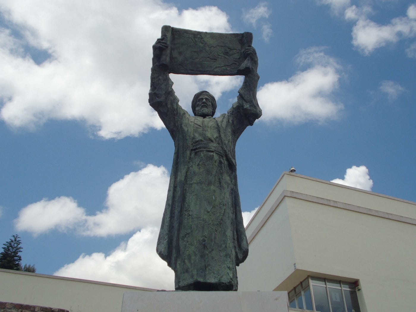
Bronze statue of Al-Idrisi holding up his map (Baluarte de los Mallorquines, Ceuta). Vardulia
He entrusted this mission to Al-Idrisi. The result was truly monumental: a work known today as the Tabula Rogeriana, literally the Book of Roger, completed in 1154. It laid the foundations of modern geography. And it was not only a cartographic achievement, but a comprehensive effort to understand the world as a whole. For example, when Al-Idrisi describes England, he writes that it is a vast and extremely fertile island, populated by valiant, active, and hardworking people, but that it endures a winter of very long duration. That’s still a fairly accurate description even today, isn’t it? In any case, it’s clear that his work goes far beyond simple cartography.
A map upside down?
When you look at Al-Idrisi’s world map, the first thing that strikes you is that it seems upside down. The South is at the top, and the North at the bottom. Upside down, yes, but only to us. Because in reality, there is no natural reason to place the North at the top of a map. It is a cultural convention that became dominant much later in Europe with the invention of the magnetic compass.
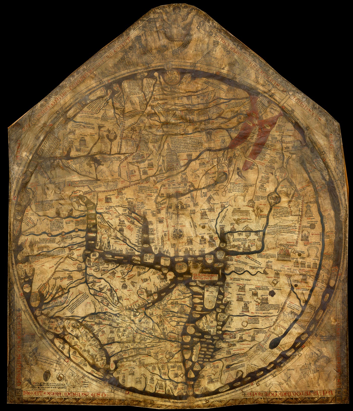
The Hereford Mappa Mundi is a Christian medieval world map created around 1300. Its purpose is more spiritual than geographic, as it features heaven, hell, and the path to salvation. The East is placed at the top, to put Paradise at the crown of the world. And there, we find the Christ Pantocrator, or Christ in Majesty.
For example, Christian maps from the Middle Ages tended to place the East at the top. According to the Bible and Christian tradition, the Garden of Eden was located in the East. Placing it at the top of the map allowed Paradise to be positioned above the rest of the world. In medieval Islamic cartographic tradition, the South was placed at the top. Why? To highlight Mecca, the holy city of Islam, which lies south of the major cultural centers of the time (Persia, Baghdad, and Al-Andalus). Placing the holy city and the Arabian Peninsula at the top of the map thus gave them a place of honor. However, there is still debate about this, since similar orientations appear in earlier traditions such as Byzantine cartography. This suggests that the practice among Arabic geographers may have had multiple cultural or historical influences.
In any case, these maps serve as a good reminder that how the world is represented also depends on the person representing it. A map is never neutral and is intimately linked to the person who draws it.
The world is a sphere
A second fascinating detail is the map’s shape itself. It is drawn like a globe, and the red lines forming arcs of a circle that cross the world are clearly visible. These are parallels, or lines of latitude. The map clearly follows a spherical logic, and the world is thus depicted as a round Earth.
Contrary to a very persistent misconception, scholars of the Middle Ages did not believe that the Earth was flat. The idea of a spherical Earth has existed since Greek antiquity and was widely accepted in the medieval scholarly world. Al-Idrisi was fully convinced of this as well. And for nearly three centuries, there would be no more advanced representation of the world than his.
Reading the world in the details
For those of you reading this article on your phone, simply rotate the screen to see a more intuitive and easier-to-interpret version of Al-Idrisi’s map. For those on a computer, watch out for a stiff neck. That’s why a rotated version, in line with today’s conventions, is also included.
Al-Idrisi’s north-oriented world map. Bodleian Library
This map is full of fascinating details and is well worth spending hours exploring. Here are a few random facts, in no particular order.
Africa takes up about half the space, and the Horn of Africa appears disproportionately large, almost gigantic. Europe is visible in the top left (bottom right if you’re looking at the original map), and Asia stretches to the right, with the Arabian Peninsula immediately recognizable. The Mediterranean clearly separates Europe and Africa, and the Indian Ocean is populated by a multitude of islands.
We also see the Nile depicted as originating from a mysterious mountain in the heart of Africa. This is a hypothesis inherited directly from the Greek geographers. We’ll come back to the Greeks later.
Another amusing detail: Sicily is depicted as about five times larger than Sardinia, even though the two islands are roughly the same size, which is a fact already well known at the time. Probably a tribute to Roger II; after all, he’s the one paying for it. A bit of cartographic product placement, so to speak.
And then there’s another detail I love. At the very top right of the map, you can read (in perfectly legible and intelligible Arabic, by the way) Yajuj and Majuj (Gog and Magog in the biblical tradition). These are two destructive peoples featured in the Abrahamic traditions. The Quran tells the story of a king named Dhû-l-Qarnayn (sometimes identified with Alexander the Great) who built a massive wall of iron and copper to confine them behind a mountain pass. And this wall is clearly visible on Al-Idrisi’s map. It reminds us that medieval maps did not strictly separate geography, history, religion, and mythology.
And finally, on a purely personal note, the blue used to represent water is absolutely sublime. Enough that I have a framed reproduction of this map in my office (the original oriented south, of course).
But how did he make such a map in the 12th century?
First of all, Al-Idrisi did not start from scratch. Like any respectable scholar, he began by studying the state of the art of his time. And the state of the art of his time was largely based on the Greek legacy.
The leading authority in geography at the time was Ptolemy (2nd century). The Greek scholar had developed a system that divided the known world into seven “climates” from north to south, corresponding to seven broad horizontal bands based on latitude. Al-Idrisi adopted this system and further divided these bands into ten segments from east to west, i.e., along the lines of longitude. The known world was thus divided into 70 sections, and Al-Idrisi’s work consisted of mapping each of these 70 zones.
To do so, he relied on his own travels but also, and above all, on countless accounts from merchants, travelers, sailors, and explorers of all kinds. These accounts were methodically cross-referenced with one another, as well as with the writings of Arab geographers and Christian scholars. Emissaries were even sometimes sent to corroborate their statements and reject contradictory information. By adopting a truly scientific approach, Al-Idrisi demonstrated a rigorous critical mind, questioning everything, cross-referencing sources, comparing stories and eliminating inconsistencies. To ensure that everything fit together, he drew scaled maps on a drafting table using an iron compass.
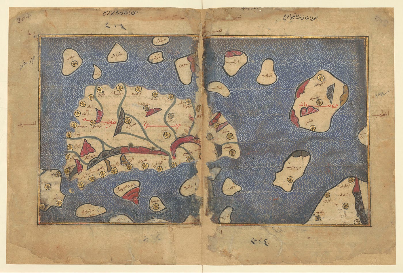
Map of Sicily from a copy of the Tabula Rogeriana (dated 1250 or 1325) held at the Bibliothèque Nationale de France. Gallica, BnF
For instance, if we look at his map of Sicily, we notice a fully developed cartographic language and effective codes of representation: the sea is shown in blue with small white ripples, the mountains as crescent-shaped symbols in various colors, the cities as small golden roses, the rivers in green, and the names of regions in large red calligraphy.
His large, complete map of the world is thus ultimately composed of 70 sheets assembled together to form a massive rectangular map of the known world. It’s a sort of giant geographic mosaic. This is similar to our modern satellites, which divide the Earth’s surface into large image tiles that are then assembled to reconstruct a global view. In the end, the logic hasn’t changed all that much.
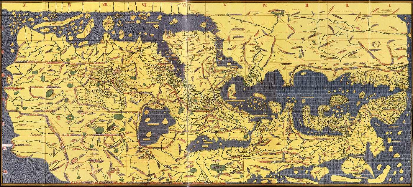
Reconstruction of Al-Idrisi’s Tabula Rogeriana, with Arabic names transcribed into the Latin alphabet. The inhabited world is divided into 7 horizontal bands extending from the equator to the North, which are themselves divided into 10 vertical sections from West to East, from the Atlantic Ocean to East Asia. This reproduction is based on a copy from the late Middle Ages (1300 or 1486). Konrad Miller
The circular map is, in reality, merely a summary, a preview, of a far more monumental achievement. It took fifteen years of work to complete, in 1154, the final version of the *Book of Roger*: the circular map, of course, but also the various sections of the much larger and more detailed rectangular map, accompanied by commentaries in Arabic. The entire work was completed barely a month before the death of Roger II of Sicily.
There is something breathtaking about contemplating this work. An entire life spent reconstructing the world from a court in Palermo, based on accounts, stories, and compass strokes on a table. A project that was completely out of the ordinary for the time.
I sometimes wonder what those great minds from another time would do if they were among us today. Probably what they do best: great and beautiful things. In a way, Al-Idrisi was already doing Earth Observation.
But from the ground.
메타데이터
- post_id
- 7abb31cb26ba
- slug
- al-idrisi-and-the-world-map-that-changed-geography-7abb31cb26ba
- url
- https://medium.com/southern-winds/al-idrisi-and-the-world-map-that-changed-geography-7abb31cb26ba
- canonical_url
- https://medium.com/southern-winds/al-idrisi-and-the-world-map-that-changed-geography-7abb31cb26ba
- author_url
- https://medium.com/@kamel.lahssini
- status
- ok
- fetched_at
- 2026-06-09 15:37:30