Bellingcat Challenge: Make the Water Turn Black
Welcome! This is a writeup describing how I solved Bellingcat’s “Make the Water Turn Black” challenge, in the “Multispectral Viewpoints”…
Bellingcat Challenge: Make the Water Turn Black
Welcome! This is a writeup describing how I solved Bellingcat’s “Make the Water Turn Black” challenge, in the “Multispectral Viewpoints” category. I would highly recommend that you attempt to solve the problem yourself before reading this article. However, I have organized this article so that you don’t get the answer until the end, so you can use this as a guide to help you through the steps if you get stuck.
The task description is as follows:
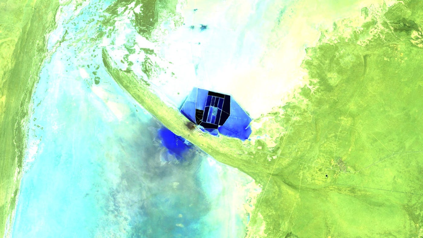
This image was captured by Landsat 8, and shows a combination of the shortwave infrared bands. This combination is useful for differentiating between different kinds of vegetation, and monitoring soil health. But here, it’s highlighting something else…
What is the name of this body of water? (omit the descriptor word i.e. ‘Lake’, ‘Reservoir’, etc)

Task image. Credit: Bellingcat (Landsat-8).
Initial thoughts
The task image is sourced from Landsat 8 (Multispectral Imagery Explorer), so a logical first step is to determine which band combination was used. This will provide insight into what features are being highlighted, helping us better understand what we are looking at.
The image uses the Shortwave Infrared band combination, which consists of bands 4, 6, and 7 from Landsat 8. This combination is commonly used to differentiate between vegetation types and monitor soil health. In this case, alkaline lakes and kaolinite mines appear blue, regular water appears black, landscapes take on various shades of green, and urban areas appear gray.
With this in mind, let’s analyze the task image. We see numerous bright blue rectangular areas, a partially dried-up body of water, and what could be a salt lake or an alkaline lake. The rectangular blue areas strongly resemble evaporation ponds, which are commonly used in lithium extraction.
Note: For information and guidance on how to interpret multispectral satellite images, I recommend reading the following article from Bellingcat: “Seeing More With Satellite Imagery Using Band Combinations, Ratios and Indices”.
Could it be lithium?
Let’s try to confirm or rule out whether the task image depicts a location involved in lithium extraction. To investigate this, I did a Google search on lithium extraction methods and found an article from MIT, which provides detailed insights into the process. You can read my summary about how lithium is extracted below.
Lithium is extracted mainly through brine evaporation and hard rock mining. In the brine method, lithium-rich water from salt flats is pumped into shallow ponds, where the sun evaporates the water over months. This method is less energy-intensive but requires large amounts of water and land.
Hard rock mining extracts lithium from minerals like spodumene. The ore is mined, crushed, and heated to change its structure, allowing lithium extraction through chemical processing. While faster and producing high-purity lithium, it consumes more energy and has a larger environmental impact.
The first explanation — where brine is pumped to the surface and evaporated in large evaporation ponds using solar heat — aligns well with the task image. In standard satellite imagery, these evaporation ponds typically appear as shown in the image below.

Salar de Atacama, Chile. Credit: Google Maps.
The idea that these bright blue rectangular areas are evaporation ponds used for lithium extraction makes sense. Such ponds contain high concentrations of salt, which would cause them to appear bright blue with the shortwave infrared combination, and their rectangular or square shape is consistent with such evaporation facilities.
Furthermore, lithium extraction using evaporation is typically found near lakes — especially salt lakes or salars in arid or semi-arid regions. These areas naturally contain large volumes of lithium-rich brine, making them ideal for extraction.
Where could it be?
Having determined that the task image most likely shows lithium extraction through the brine method, the next step is to pinpoint its exact location. To do this, I found an article from Mining Technology listing the world’s ten largest lithium mines. I then examined these sites using Bellingcat’s Multispectral Imagery Explorer to identify a match.


Salar de Atacama, Chile (left). Greenbushes Lithium Operations, Australia (right). Credit: Bellingcat’s Multispectral Imagery Explorer.
Unfortunately, none of the locations from the initial list matched the task image. To expand the search, I found a much more comprehensive list compiled by the British Geological Survey, which includes 88 different lithium extraction sites. This list categorizes each site based on the extraction method, making it easier to narrow down the search to locations that use the brine evaporation process.

Global Lithium Deposit Map. Credit: British Geological Survey.
I checked all relevant locations, those marked in blue and purple, using Multispectral Imagery Explorer, but none were a match. This suggests that the task image depicts a lithium extraction site, but likely one in a region where large-scale lithium production is relatively new. If it had been a well-established site, it would probably have been included on the British Geological Survey’s list.
Who is new to the game?
At this stage, the goal is to locate a lithium extraction site that uses the brine evaporation method, but one that has not been a major production site for long. Since the site does not appear on established lists of large-scale lithium operations, it is reasonable to assume that this is a newer or emerging lithium extraction region. The logical approach now is to identify countries or regions that have recently started with lithium extraction, or recently had big discoveries of lithium.
Finding information on new lithium extraction sites turned out to be more difficult than expected, so I had to refine my search with region-specific Google queries like “lithium discoveries asia” and “lithium discoveries africa.” While some results were irrelevant, I came across articles mentioning recent lithium discoveries in Thailand and India.
The discovery in Thailand initially seemed promising, but further reports showed that the actual lithium reserves were much smaller than first estimated. These locations was ultimately not a match. A significant lithium find in the Kashmir region of India sparked a lot of optimism, but efforts to start extraction ran into issues. However, this was one of the few new lithium sites that I couldn’t immediately rule out, making it worth investigating further.
Could it be India?
At this point, India seems like the most logical option. The country has recently made major lithium discoveries and is already one of the world’s largest salt producers. Additionally, an article from East Asia Forum highlights the strategic importance of developing an independent lithium supply chain to support future growth, drive the transition to green energy, and reduce strategic vulnerabilities.
India is set to become the sixth-largest holder of lithium resources worldwide, ahead of China. -Peterson Institute for International Economics.
In my searches about lithium discoveries in India, I came over an article from Evolute Group. The article mentions lithium discoveries in Rajasthan, Jammu and Kashmir. In Rajasthan, lithium deposits have been discovered in the Sambhar Salt Lake and surrounding areas — containing lithium-rich brines. In Jammu and Kashmir, lithium have been discovered in Ladakh region, in lithium-bearing pegmatites (rocks).
Out of these options, the Sambhar Salt Lake makes the most sense. The area contains lithium-rich brines, which align with the brine extraction method and the evaporation ponds seen in the task image.
To confirm or rule out this possibility, I checked Sambhar Salt Lake on Multispectral Imagery Explorer. Fortunately, I can confirm that this is the same location as in the task image, which can be easily verified by looking at the distinctive rectangular evaporation ponds, the partially dried lakebed, and the striking bright blue body of water just south of the main lake.
NOTE: The exact answer is “Sambhar”.


LEFT: Sambhar Salt Lake, India (Credit: Bellingcat’s Multispectral Imagery Explorer). RIGHT: Sambhar Salt Lake, India (Credit: Google Maps).
Summary
The task image showed bright blue evaporation ponds, suggesting lithium extraction using the brine method. To identify the location, I first checked major lithium mining sites using Mining Technology’s list and the British Geological Survey’s lithium deposit map, but none matched. This indicated that the site was likely a newer lithium extraction area.
I then searched for countries recently investing in lithium mining, leading me to India, where large a lithium-rich brine deposit were discovered in Sambhar Salt Lake, Rajasthan. Checking the lake in Multispectral Imagery Explorer, I found a perfect match: the rectangular evaporation ponds, partially dried lakebed, and a bright blue body of water south of the lake confirmed that Sambhar Salt Lake was the correct location.

Tools
- Bellingcat’s Multispectral Imagery Explorer
- Google Search and Google Maps
메타데이터
- post_id
- 801ed6bca85e
- slug
- bellingcat-challenge-make-the-water-turn-black-801ed6bca85e
- url
- https://medium.com/@dam_coffee/bellingcat-challenge-make-the-water-turn-black-801ed6bca85e
- canonical_url
- https://medium.com/@dam_coffee/bellingcat-challenge-make-the-water-turn-black-801ed6bca85e
- author_url
- https://medium.com/@dam_coffee
- status
- ok
- fetched_at
- 2026-07-08 12:17:00