Working with CORDEX Climate Projections: how to unrotate a rotated pole grid using GDAL and Python
Have you ever downloaded climate projection data and realized it comes in a rotated pole grid? A prime example would be CORDEX (Coordinated…
Working with CORDEX Climate Projections: how to unrotate a rotated pole grid using GDAL and Python
Have you ever downloaded climate projection data and realized it comes in a rotated pole grid? A prime example would be CORDEX (Coordinated Regional Climate Downscaling Experiment).
Given you have a climate projecton from model run from the Cordex Initiative like evspsbl_EUR-11_ICHEC-EC-EARTH_rcp85_r12i1p1_CLMcom-CCLM4–8–17_v1_day_20160101–20201231.nc. And your first input to QGIS looks like this:
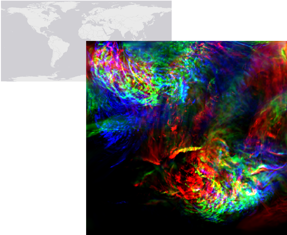
Beautiful data, odd localization, Basemap: © ESRI Gray (light)
Note that the filename usually gives away a lot of information. In this case evspsbl refers to the datatype within the data: evapotranspiration. EUR-11 is the Cordex Domain. You can check the meta data here, there you’ll find something like this:
double rlat(rlat) ;
    rlat:units = "degrees" ;
    rlat:axis = "Y" ;
    rlat:long_name = "latitude in rotated pole grid" ;
    rlat:standard_name = "grid_latitude" ;
double rlon(rlon) ;
    rlon:units = "degrees" ;
    rlon:axis = "X" ;
    rlon:long_name = "longitude in rotated pole grid" ;
    rlon:standard_name = "grid_longitude" ;
int rotated_latitude_longitude ;
    rotated_latitude_longitude:grid_mapping_name = "rotated_latitude_longitude" ;
    rotated_latitude_longitude:grid_north_pole_latitude = 39.25 ;
    rotated_latitude_longitude:grid_north_pole_longitude = -162. ;
    rotated_latitude_longitude:north_pole_grid_longitude = 0. ;
The "latitude in rotated pole grid” is a problem, because the rest of your data is in a regular coordinate reference system (e.g. EPSG: 4326). Now, you need to harmonize this with the rest of your data. Once again GDAL has you covered! In this case we need gdalwarp. You can check out the options for gdalwarp in the documentation. You can either use it straight from the commandline or from within Python. Depending on your installation and operating system you might have to navigate into a folder where gdalwarp is located. The \bin folder of your QGIS installation is a good start.
Commandline
[embed]
Python
If you are keen on batch processing/calling everything from within python, you can. Also, check out the GDAL Python API https://gdal.org/python/.
[embed]
메타데이터
- post_id
- 8e8561cb02d3
- slug
- working-with-cordex-climate-projections-how-to-unrotate-a-rotated-pole-grid-using-gdal-and-python-8e8561cb02d3
- url
- https://medium.com/@hoffmann.magnus/working-with-cordex-climate-projections-how-to-unrotate-a-rotated-pole-grid-using-gdal-and-python-8e8561cb02d3
- canonical_url
- https://medium.com/@hoffmann.magnus/working-with-cordex-climate-projections-how-to-unrotate-a-rotated-pole-grid-using-gdal-and-python-8e8561cb02d3
- author_url
- https://medium.com/@hoffmann.magnus
- status
- ok
- fetched_at
- 2026-07-26 12:24:21