Nigeria’s Land Records Problem Isn’t What You Think It Is
The bottleneck isn’t bureaucracy. It’s architecture.
Nigeria’s Land Records Problem Isn’t What You Think It Is
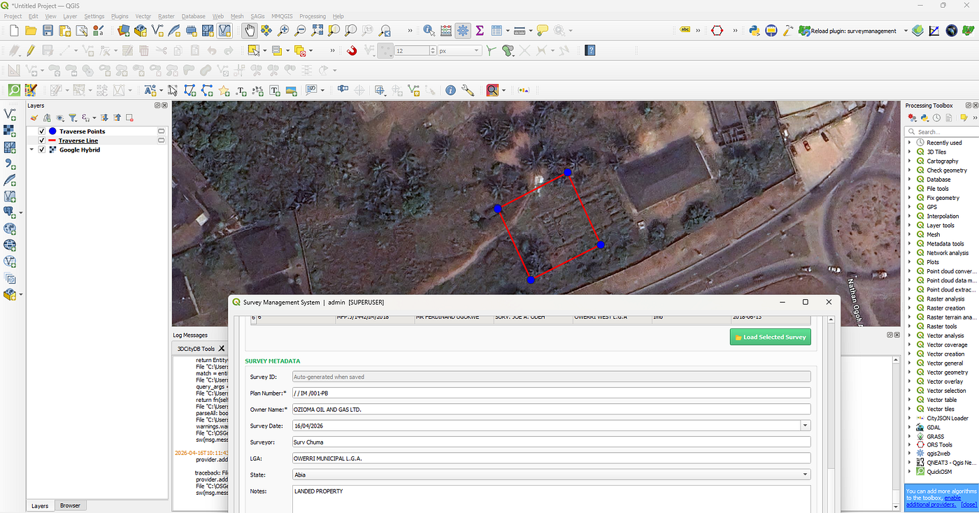
Beacon coordinates and traverse legs from a cadastral plan, plotted automatically from an AutoCAD DXF file using the Survey Management System plugin
The bottleneck isn’t bureaucracy. It’s architecture.
Ask most people what’s wrong with land administration in Nigeria, and they’ll say: corrupt officials, unclear titles, slow courts, and political interference. All real problems. But spend time inside a private cadastral survey firm, as I did as a pupil surveyor, and you find a different kind of problem. One that nobody talks about, partly because it doesn’t look like a problem at all.
Most Nigerian survey firms are well structured. Files are organised. Records are maintained. The principal surveyors often run a tight ship. When there is a need for a search, for instance: the closest survey within an area to serve as a survey base / origin, an experienced hand could find it in about 5 to 20 minutes.
That much time to find a file that already exists in a well-organised office. That gap, multiplied across every firm, every state, every boundary dispute in Nigeria, is where land administration quietly fails.
What actually happens when a survey is done
Here is the workflow, which I want to document because, as far as I can tell, it has never appeared in the published literature on Nigerian land administration.
A licensed surveyor goes to the field, captures the parcel boundaries and coordinates, comes back to the office, and draws the plan in AutoCAD. The firm then submits both a printout and an electronic file to the State Ministry of Lands. The Ministry reviews it, assigns official beacon numbers and a plan number, and the finalised plan goes to the client. A red copy goes back to the Ministry for official archiving.
Six steps. At each step, data that already exists in digital form gets printed, submitted, re-keyed by someone else, and filed somewhere new. The same parcel is described in the surveyor’s field book, the firm’s AutoCAD file, the ministry’s submission register, and the client’s envelope. These four records are supposed to be identical. Over time, they rarely are.
When a boundary dispute arises, which is exactly when this data matters most, someone has to go find the right version of the right document. Manually. And hope it matches what the ministry has.
The structural issue
This is not a criticism of the people involved. The surveyors and ministry staff are doing their jobs with the systems available to them. The problem runs deeper than that.
Paper cannot be spatially queried. You cannot ask a filing cabinet to show you all surveys within 500 metres of a given location, or whether the parcel you are about to survey overlaps with one surveyed five years ago by another firm. Those questions, which matter enormously for boundary disputes, planning decisions, and tenure security, simply cannot be answered with the existing system.
The national LIS model assumes data flows upward from surveys through ministries into a central database. But that pipeline has a chokepoint: the re-entry step, where paper submissions are manually entered into government systems by staff who were not present at the survey. Every keystroke is an opportunity for error. Every delay is a growing gap between ground reality and the official record.
What makes this particularly frustrating is that the licensed survey firms generating this data are the people who know the most about it. They captured it, computed it, and drew it. Then they hand it over in a format that strips out the spatial intelligence and requires someone else to rebuild it from scratch on the other end.
What I found while building a tool for this
I have been working on a free, open-source QGIS plugin called the Survey Management System, designed specifically for Nigerian cadastral firms. During that process, I discovered something that changed how I think about the whole integration problem.
The AutoCAD files that survey firms already draw, the same ones they already submit to ministries, contain everything needed for a structured spatial database. The boundary polyline already encodes the traverse sequence. The title block already contains the plan number, owner name, and surveyor details. The coordinate annotations already have the grid reference values.
Nothing new needs to be captured. The data is there. It just needs to be read by something more capable than a printer.
When I built a DXF import engine that reads the boundary polyline directly from an AutoCAD file, it automatically extracted the beacon coordinates, the traverse legs in the correct traversal order, the starting point, the grid control coordinate, and the full title block metadata, including plan number, owner name, surveyor, date, and state. No manual re-entry at all.
The implication of this is significant: the transition from an isolated AutoCAD workflow to a structured spatial database does not require surveyors to change how they work. It requires a bridge at the point where the AutoCAD output currently gets printed and filed.
What a better architecture looks like
The model I am proposing is federated rather than centralised. Survey firms become standardised data nodes rather than paper submitters. Their digital outputs feed a national LIS through a compliance layer rather than through a re-entry pipeline.
Think of how financial transactions work. When you make a payment, the data does not get printed and handed to someone to re-key into the central bank’s database. It flows directly, in a standard format, through a compliance layer that validates it. The central bank maintains the authoritative record, but the data originates at the transaction point. Cadastral data should work the same way.
Under this model, survey firms create data using certified tools that produce compliant output. State ministries validate submissions, assign official numbers, and maintain the authoritative record. National systems aggregate and make that data available. The government’s role does not shrink; it becomes more useful. Ministry staff become validators rather than data entry clerks. The national LIS gets updated at the point of survey completion rather than months later.
What already exists
The data origination layer of this architecture is built. The Survey Management System plugin has been available on the QGIS Plugin Repository since April 2026 and has picked up more than 38 downloads in the first 72 hours, which tells me practitioners have been waiting for something in this space.
The plugin does things the current workflow cannot. It retrieves any survey record in under two seconds. It runs spatial queries that are impossible with a paper system. It imports AutoCAD plans without re-entry. It detects boundary conflicts with adjacent surveys automatically. It enforces the NIS 1:5000 precision standard on every traverse computation. It verifies document integrity for 50-year archival durability.
What it does not yet do, because the infrastructure does not exist, is submit directly to a ministry LIS. That requires three things to be built at the national level.
The three things the government needs to provide
First, a national cadastral data schema. A published definition of the minimum dataset for a plan submission: boundary geometry, plan identifier, owner record, CRS, and quality evidence. This is essentially a document. It costs relatively little to develop, and it unlocks everything else.
Second, a software certification framework. A mechanism for assessing whether survey tools produce schema-compliant output. Certified tools submit directly. This is not unlike how NIS already certifies survey competence, applied to software instead.
Third, ministry API endpoints. Each State Surveyor General’s Office publishes an API that accepts digital submissions in the national schema format, returning immediate validation results. Direct submission, no re-keying, no delays.
These three things, combined with tools that already exist, would allow survey firms to feed validated, authoritative data into the national LIS at the point of creation rather than six steps later through a paper pipeline.
Why this matters
Land tenure security is one of the strongest predictors of household investment, housing quality, and poverty reduction. A reliable land information system is not a technical nicety; it is economic infrastructure. Nigeria has the surveyors, the professional standards, and, with open-source tools, the technology. What it lacks is the governance infrastructure to connect them.
The data already exists. It is sitting in AutoCAD files and filing cabinets across hundreds of survey firms. The question is whether we are willing to build the bridge.
Ugwu Chukwuma is a researcher at the Centre for Geodesy and Geoinformatics, HFT Stuttgart, and the developer of the Survey Management System QGIS plugin. The plugin is freely available at the QGIS Plugin Repository. A full research paper and a formal concept proposal on this topic are in preparation.
Tags: #LandAdministration #Nigeria #GIS #Surveying #OpenSource #LandInformationSystem #QGIS #Geospatial #CadastralSurveying
메타데이터
- post_id
- 95b1e878f6f7
- slug
- nigerias-land-records-problem-isn-t-what-you-think-it-is-95b1e878f6f7
- url
- https://medium.com/@ugwusochukwumaobimsamuel/nigerias-land-records-problem-isn-t-what-you-think-it-is-95b1e878f6f7
- canonical_url
- https://medium.com/@ugwusochukwumaobimsamuel/nigerias-land-records-problem-isn-t-what-you-think-it-is-95b1e878f6f7
- author_url
- https://medium.com/@ugwusochukwumaobimsamuel
- status
- ok
- fetched_at
- 2026-08-12 07:44:42