Four Old Drill Holes May Have Tested the Wrong Part of the System
Four relatively shallow holes are not enough to dismiss a potentially larger buried intrusive target. Put four points on a map and they can…
Four Old Drill Holes May Have Tested the Wrong Part of the System
Four relatively shallow holes are not enough to dismiss a potentially larger buried intrusive target. Put four points on a map and they can look like a complete drill program. Place those same four points inside a 45.74-square-kilometre corridor affected by younger cover, faults and several intrusive phases, and they begin to look more like an early geological sample.
That distinction matters at Trojan–Condor. In 2014, four holes were drilled for a combined 728 metres. The individual holes ranged from approximately 135 to 215 metres, giving an average length of only about 182 metres per hole. For rough context, four holes across 45.74 square kilometres are equivalent to approximately one historical hole for every 11.4 square kilometres of ground. The drilling was not distributed evenly, so that is not a technical drill-density calculation. It does show how lightly tested the wider corridor remains.
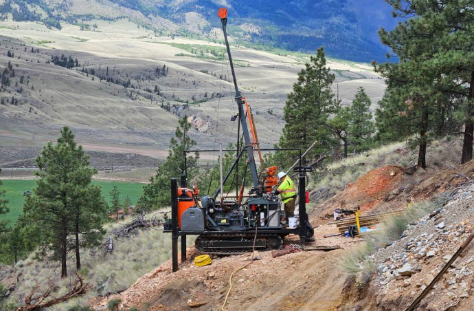
The program confirmed intrusive rocks, hydrothermal alteration, sulphides and anomalous copper. It did not establish whether the strongest part of the system had been reached. I think that is the more useful way to read the old results. A total of 728 metres can provide valuable geological information, but it cannot settle every question about a buried target whose depth, orientation and centre were still uncertain.
The assays were modest, but the geology was active
The historical holes intersected intrusive phases described as diorite, gabbro and pyroxenite. Core review also identified epidote and sericite alteration, carbonate-quartz veinlets, pyrite and traces of chalcopyrite. Several copper intervals were reported from the historical core. One re-sampled section returned a weighted average of 1,084 ppm copper over 3.13 metres, equivalent to approximately 0.108% copper. Broader anomalous intervals included approximately 381 ppm copper over 26.83 metres, or 0.038% copper, and 262 ppm over 24.16 metres, equivalent to about 0.026% copper.
These are not economic discovery grades, and they should not be presented as such. What they show is that copper anomalism was not limited to a single isolated sample. The drilling encountered both shorter, stronger copper values and broader lower-grade intervals inside altered intrusive rocks.
That combination is geologically more interesting than one headline assay. It indicates that hydrothermal fluids moved through multiple sections of the core and affected tens of metres of rock. The unanswered question is where those intervals sat within the broader system.
A hole positioned in a peripheral alteration zone can carry pyrite, traces of chalcopyrite and anomalous copper over meaningful widths while remaining outside the strongest mineralized centre. A hole can also pass through a small intrusive branch without reaching the larger body responsible for the wider magnetic or chargeability response. The old core therefore confirms the right type of geological activity. It does not prove that the best location was tested.
An average depth of 182 metres leaves room below
The deepest historical hole reached approximately 215 metres. The shallowest was close to 135 metres, an 80-metre difference between the longest and shortest tests. Those depths are meaningful for testing near-surface showings and IP responses. They may still be limited when the exploration model includes younger Princeton Group cover, structural displacement and a possible deeper intrusive source.
A 182-metre average hole does not necessarily provide 182 metres of effective target testing. Part of the hole may pass through cover, weakly altered host rocks or geological units positioned above the intended intrusive level. The angle of the holes matters as much as their length.
A hole can reach 200 metres and still pass beside a steep contact. It can intersect the upper edge of an intrusive branch while leaving the broader body untested. It can also remain on one side of a fault when the main target has been displaced onto another structural block. This is why the total of 728 metres should not be interpreted as 728 metres through the core of one defined target. It represents four narrow paths through a much larger and still-evolving geological model.
The 2014 holes were designed around the surface showings and induced-polarization interpretation available at that time. The earlier 2011 three-dimensional IP survey was an important targeting tool, but it did not provide the complete subsurface picture that could be developed by combining the drilling with later magnetic, structural and geochemical interpretation. The old program answered four specific targeting questions. The broader intrusive model now creates several new ones.
The numbers can become vectors
Historical drilling often gets reduced to three columns: metres, grade and interval. At Trojan–Condor, the more valuable numbers may be the positions where lithology, alteration and sulphides changed within the holes.
NRED can examine where diorite gave way to gabbro or pyroxenite, where sericite or epidote became stronger, and where pyrite and chalcopyrite first appeared. Those depths can then be compared with the geometry of interpreted faults, intrusive contacts and geophysical responses. The three reported copper intervals also provide different kinds of information.
The 1,084 ppm over 3.13 metres interval marks a relatively stronger but narrow section. The 381 ppm over 26.83 metres result shows lower-grade anomalism across a much broader width. The 262 ppm over 24.16 metres interval provides another extended section of elevated copper. Viewed together, those numbers may help determine whether the holes crossed isolated veins, a broader altered envelope or a directionally changing hydrothermal system.
A historical hole that appeared inconclusive in 2014 may now help define an outer boundary. A hole ending with stronger alteration or increasing copper could suggest that drilling stopped while still moving toward a more prospective area. A broader low-grade interval may indicate that the hydrothermal footprint is wider than the short higher-grade section alone suggests. That is how old core becomes a targeting tool rather than an archived result.
The next holes should test what the first four left open
The case for revisiting Trojan–Condor is not based on pretending that the historical grades were exceptional. It is based on the amount of geological space that remains unresolved.
Four holes tested 728 metres across a corridor covering 45.74 square kilometres. Their average length was approximately 182 metres, and none extended beyond about 215 metres. They encountered three reported copper intervals ranging from 3.13 to 26.83 metres, intrusive rocks, hydrothermal alteration and sulphides. Those numbers are enough to confirm that the drilling entered an active intrusive environment. They are not enough to demonstrate that the centre, depth or full geometry of the system was properly tested.

A modern follow-up program does not need to repeat the original collar locations. The strongest new target may sit deeper than 215 metres, beside the old hole traces or beneath younger cover away from the best surface showing. The next holes should be placed where several datasets overlap: intrusive geometry, fault position, alteration vectors, copper trends in the historical core and the depth of the geophysical source.
That could mean a deeper test. It could mean drilling from a different direction. It could also mean moving away from the narrow 0.108% copper interval and targeting the geological structure believed to have created the wider hydrothermal footprint. At Trojan–Condor, four old holes did not close the target. They established four fixed reference points, three reported copper intervals and 728 metres of subsurface evidence that NRED can now place inside a more precise three-dimensional model. The historical program may have entered the correct geological system from the wrong position — or stopped before reaching the level that mattered most. The next opportunity is to use those numbers to determine where the first four holes never went.
메타데이터
- post_id
- 96d8abff5ccf
- slug
- four-old-drill-holes-may-have-tested-the-wrong-part-of-the-system-96d8abff5ccf
- url
- https://medium.com/@william.jio121/four-old-drill-holes-may-have-tested-the-wrong-part-of-the-system-96d8abff5ccf
- canonical_url
- https://medium.com/@william.jio121/four-old-drill-holes-may-have-tested-the-wrong-part-of-the-system-96d8abff5ccf
- author_url
- https://medium.com/@william.jio121
- status
- ok
- fetched_at
- 2026-07-31 07:06:29