There is no Geo in GeoAI
TL;DR
There is no Geo in GeoAI
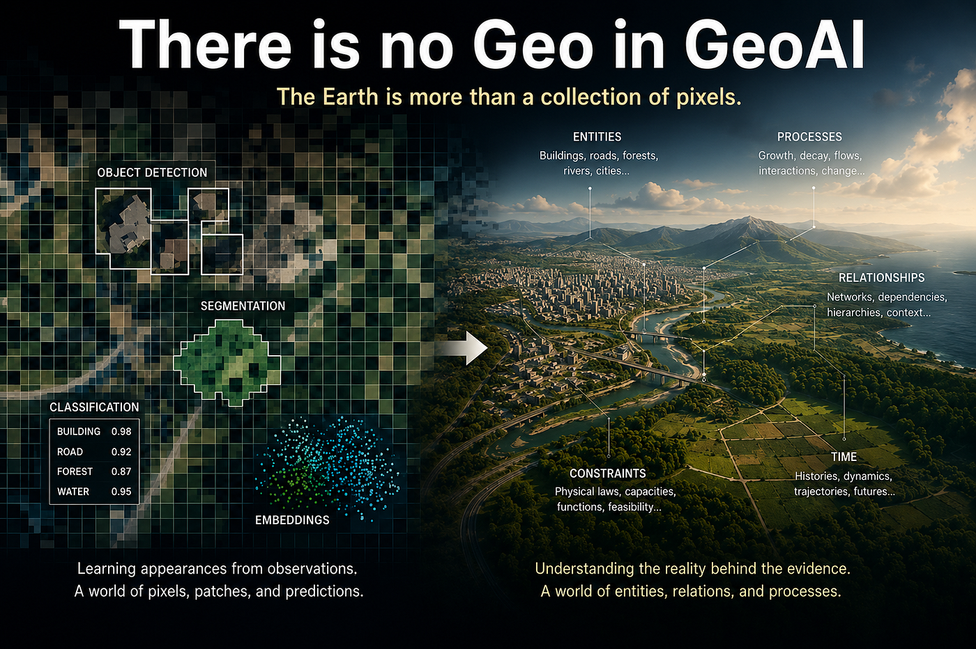
The current state of GeoAI is The architecture is still framed as: more sensing → better model → better decisions. I think, that sensing the Earth is not the same as understanding the Earth.
TL;DR
Much of today’s GeoAI is not actually learning geography. It is learning patterns in Earth observation imagery. Geography, however, is not imagery. It is the study of entities, processes, and relationships embedded in space and time. A satellite image is an observation of geography, not geography itself. Until GeoAI moves beyond recognizing appearances and begins reasoning about the underlying reality those observations represent, the Geo in GeoAI will remain largely absent.
The Uncomfortable Observation
The Earth does not consist of pixels. Pixels are merely one of the many ways in which the Earth reveals itself to us.
We call it GeoAI, but much of today’s GeoAI contains very little geography. This is not because the field lacks technical progress. Quite the opposite. GeoAI has produced impressive systems for extracting buildings, roads, land cover, flood extent, crop types, vessels, forests, and many other patterns from Earth observation data. The progress is real, and much of it is useful.
The problem is deeper. Much of what is called GeoAI is, in practice, computer vision applied to Earth imagery. The Earth is cut into tiles, transformed into patches, compressed into embeddings, and evaluated through classification, segmentation, detection, or change maps.
At that point, something essential is lost. A satellite image is not geography. It is an observation of geography. It is a measurement taken from a particular sensor, at a particular time, under particular atmospheric, geometric, seasonal, and political conditions. Treating this observation as if it were the world itself is the first conceptual mistake. The result is a field that often becomes very good at recognizing appearances, while remaining much weaker at representing the geographic reality behind those appearances.
Geography Is Not Imagery
Remote sensing does not observe geography. It observes evidence of geography.
Geography is often reduced to maps, coordinates, and increasingly to satellite imagery. Yet geography has never been about images. Geography is the study of entities, processes, and relationships embedded in space and time.
A building is not merely a visual pattern observed from above. It occupies a location, interacts with surrounding infrastructure, serves a function, evolves through time, and exists within a broader social, economic, and physical context. The same is true for forests, roads, rivers, cities, and agricultural systems.
When a geographer studies a city, the objective is not simply to identify its buildings. The objective is to understand how those buildings relate to transportation networks, economic activity, demographic change, environmental conditions, and future development. The image is useful because it provides evidence. It is not useful because it is the thing being studied.
This distinction matters because geography is fundamentally relational. A road disconnected from a network is no longer the same geographic object. A building isolated from its surroundings loses much of what makes it geographically meaningful. A flood cannot be understood without considering the terrain, infrastructure, hydrology, and temporal evolution that produced it.
Geography is therefore not the study of appearance. It is the study of how things exist, interact, and change across space and time.
The World Is Not a Collection of Images
Appearance tells us what something looks like. Geography asks what it is, how it relates, and how it changes.
If geography is not imagery, then what exactly are we studying? The answer is not obvious, because we never observe the world directly. We observe measurements of the world. Satellite images, SAR acquisitions, LiDAR point clouds, cadastral maps, GPS traces, and census records are all observations. They are partial, incomplete, and often noisy glimpses of an underlying reality. Yet much of GeoAI implicitly treats these observations as the primary object of study: A building becomes a collection of pixels, a road becomes a segmented line or a flood becomes a water mask. But the physical world does not consist of pixels, textures, lines, or masks. These are representations we impose upon observations.
A building exists within a range of physically possible states. It can be maintained, renovated, damaged, expanded, abandoned, or repaired while remaining the same building. A road can be partially obstructed, degraded, resurfaced, or flooded. A city can grow, shrink, densify, or decline. What matters is not a single observation, but the space of possibilities that remains consistent with reality.
The distinction is subtle but fundamental. GeoAI often learns to recognize observations. Geography seeks to understand the reality those observations refer to.
GeoAI Learns Appearance, Not Geography
GeoAI often learns how reality appears. Geography seeks to understand how reality works.
Current models are exceptionally good at learning appearance. Given enough data, they can learn the visual signatures of buildings, roads, forests, ships, floodwater, agricultural fields, and countless other patterns.
But appearance is not geography. Two locations may appear visually similar while playing completely different roles within a larger system. Two roads may look identical from above, yet one may be a critical transportation corridor while the other serves a local neighborhood. Geography is not only concerned with what things look like. It is concerned with where they are, how they relate to other things, how they change through time, and what role they play within larger spatial systems.
A model that identifies a building has recognized an appearance. A model that understands how that building interacts with infrastructure, economic activity, population dynamics, and future development has begun to learn geography. The difference is profound. One learns patterns in observations. The other attempts to understand the reality that generated those observations.
Why This Matters
At this point, one might reasonably ask: “Does any of this actually matter?”. If a model can detect buildings, segment roads, map flood extent, classify land cover, and estimate crop yields with high accuracy, why should we care whether it understands geography? Because recognizing appearances and understanding geographic reality are not the same thing. A system that learns appearances can tell us what is visible. A system that understands geography can reason about what is possible.
The difference becomes critical the moment we move beyond mapping and begin asking questions about prediction, planning, resilience, adaptation, infrastructure, risk, and decision making. Can a city continue to function if a bridge fails? Which roads remain accessible during a flood? How will a settlement evolve over the next decade? What infrastructure is most vulnerable to disruption? What happens when observations are missing?
These are fundamentally geographic questions. They question about entities, processes, relationships, and dynamics. They are questions about the state of the world rather than the appearance of the world. Most current GeoAI systems cannot answer them. Not because they lack parameters. Not because they lack training data. But because these are not questions about appearance. They are questions about reality.
A More Uncomfortable Question
The irony is that GeoAI was never supposed to be merely about image classification. Many of the field’s own definitions describe GeoAI as the development of systems capable of spatial reasoning and the discovery of geographic phenomena and dynamics. GeoAI was supposed to help us understand how the world works, not merely how it looks.
Yet much of the field’s energy has increasingly converged on learning representations from observations. We are building increasingly powerful systems for understanding Earth observations. The question is whether we are building systems that understand the Earth itself. If the answer is no, then many of the problems we ultimately care about, prediction, planning, resilience, adaptation, and decision support, may remain fundamentally out of reach.
Which raises an even more uncomfortable question. If learning better representations is not the same as learning geography, what exactly are Geo Foundation Models learning? Read about this in part two of this series.
References and Further Reading
Many of these works focus on representation learning, multimodal modeling, and large-scale Earth observation. They are important contributions. The argument of this article is not that these approaches are unimportant. Rather, it is that representation learning alone should not be confused with geographic understanding.
Goodchild, M. F. (2013), Prospects for a Space-Time GIS: Space-Time Integration in Geography and GIScience. Annals of the Association of American Geographers, 103(5), 1072–1077. https://doi.org/10.1080/00045608.2013.792175
Gao, S., Hu, Y., Li, W. et al. (2023), Special issue on geospatial artificial intelligence. Geoinformatica 27, 133–136. https://doi.org/10.1007/s10707-023-00493-6
Mai et al. (2023), On the Opportunities and Challenges of Foundation Models for Geospatial Artificial Intelligence. arXiv:2304.06798
Xiao et al. (2024), Foundation Models for Remote Sensing and Earth Observation: A Survey. arXiv:2410.16602
Yang et al. (2025), Survey of Multimodal Geospatial Foundation Models. arXiv:2510.22964
Corley et al. (2026), No One Knows the State of the Art in Geospatial Foundation Models. arXiv:2605.12678
메타데이터
- post_id
- 9c0515497770
- slug
- there-is-no-geo-in-geoai-9c0515497770
- url
- https://medium.com/@Monodrom/there-is-no-geo-in-geoai-9c0515497770
- canonical_url
- https://medium.com/@Monodrom/there-is-no-geo-in-geoai-9c0515497770
- author_url
- https://medium.com/@Monodrom
- status
- ok
- fetched_at
- 2026-06-23 19:38:28