The relationship between elevation, soil properties and vegetation cover in the Shorb-Ol-Ain…
Abstract
The relationship between elevation, soil properties and vegetation cover in the Shorb-Ol-Ain watershed of Yazd
Abstract
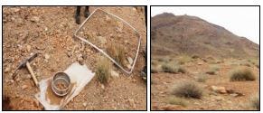
Determination of the relationship between **topography**, vegetation and soils is essential factor in planning and management of arid areas. This study aimed to determine the relationship between the elevation, soil properties and vegetation cover in the Shorb-Ol-Ain watershed of Yazd. The purpose of this study was to identify the relationships between elevation, soil properties and vegetation cover in the watershed in order to protect soil and water and reclamation of watersheds. Eighteen land units were determined through overlaying maps of slope, aspect and elevation using the geographic information system as a basis for soil and vegetation sampling. In each land unit, samples were taken randomly in three reapplication using the vegetation plot and soil sampling to a depth of plants rooting and soil samples were tested to determine the percentage of gravel, sand, silt, clay, lime and Electrical Conductivity (EC), power of Hydrogen (pH), and organic matter content. The relationship between the elevation, vegetation and soil were analyzed using SPSS software and considering the obtained results, it was found that the elevation has an impact on the percentage of the vegetation cover. Among the studied soil factors, only there was a significant relationship between the elevation and percentage of gravel, EC and organic matter content. According to the results of this study, physiochemical properties of soil and percentage of the vegetation cover are partly under the influence of elevation So that at higher elevations because of more moisture and lower livestock grazing, the percentage of the vegetation cover was significantly higher than lower elevations. At higher elevations, the rock and gravel amount were also more than lower elevations. On the other hand, at lower elevations, soil organic matter and soil salinity is greater than the higher elevations due to the transmission of the material by runoff and their accumulation in the lower parts of the watershed.

Introduction
In Yazd with arid and semi-arid climate, there is high restrictions for agricultural and biological measures. In this region there are some single mountains that make microclimate because of elevation changes. This microclimate can affect on soil and vegetation. Knowing this relation can help **agriculture** and natural resources manager for vegetation development, biological soil conservation and land planning.
Distribution pattern and abundance of species and plant communities in different areas, especially in arid areas often is related to three groups of environmental factors: the physical variables, soil chemical properties and human impacts (Enright et al., 2005). There is a special relationship between environmental characteristics and vegetation in a region (Arshad et al., 2008). Among environmental factors, parameters such as slope, aspect, elevation and other environmental factors have effects on soil physical and chemical parameters (Enright, et al., 2005). Topography directly through changes and adjustments on environmental factors, and indirectly through its effect on soil formation has a major impact on plant communities. The knowledge of topography characteristics is necessary to manage these lands. Topography through effects on soil moisture and microclimate has a significant impact on the characteristics of the ecosystem and controls vegetation patterns (Clark, 1990).
There is a close relationship between some environmental factors, percentage of the vegetation cover and density of dominant species. Identification of these relationships plays an important role in preservation of vegetation, soil and water and in conservation, improvement and restoration of range lands (Shokrollahi et al., 2012). Each land unit has a unique slope, aspect and elevation thus it has different conditions for the growth and development of plants (Moradi and Ahmadipour, 2006). Physical and chemical properties of the soil play a major role in creating change and diversity in rangelands, on the other hand rangelands play an important role in the development of the soil properties. The Separate investigation of the vegetation cover or physiographic features are not the systematic way to evaluate and classification of the habitat, but a simultaneous study of vegetative and environmental factors can have a more favorable result (Fisher and Fuel, 2004). In addition to the topography, the land use is also effective on soil characteristics. In general, changes in land use affect the soil quality and the physicochemical properties of the soil, the physicochemical properties of soil play an important role in watershed erosion (Emami et al., 2014). Spatial variability of soil characteristics is a function of environmental factors such as climate and landscape characteristics, including location, topography, slope, elevation, parent materials and native vegetation (Maleki et al., 2013). The effects of topographic variables and soil physicochemical properties on the performance of effective parameters on the growth of Artemisia siberia in Nodooshan stepped rangelands was investigated using Redundancy Detrended Analysis method (RDA) showed that there is a significant relationship between the vegetative characteristics of Artemisia sieberi, soil variables and topography (Abdollahi and Naderi, 2013). Studies regarding the effects of various factors of climate, soil and topography on the vegetation cover of the central rangeland of Argentina have been carried out by Cantero et al. (2003), They showed that in addition to the above variables, the soil nutrient plays an important role in plant distribution. Xu et al., 2008 using the field survey of vegetation, soil and topography variables in the valley of the Min Jiang River in China, concluded that elevation, vegetation cover, variety of good quality soils, the favorable topographical situation, radiation, runoff and soil erosion potential are directly related. Rossi et al., 2014 carried out a study to explore the relationship between vegetation, soils and geomorphology in Italy. 168 kinds of relationships was discovered between different types of vegetation, soils and geomorphology and 1092 relationships were discovered between land cover variables and topography. Masoumi et al., 2014 also showed topography affecting on landslides occurrence by spatial multi criteria evaluation (SMCE) by GIS modeling in humid region. Determine the factors which control the presence and relative abundance of the plant species in arid and semi-arid areas is one of the main objectives of the research in such areas, because the quantitative analysis of the relationships can be useful in the management of the species in such regions (He et al., 2007). The purpose of this study was to explore the relationship between elevation, soil and vegetation properties in an arid and semi-arid climate in single mountain microclimate in order to complete missing studies and predict the accurate and stable responses to maintain and protect soil and water resources.
메타데이터
- post_id
- bbc2817447ff
- slug
- the-relationship-between-elevation-soil-properties-and-vegetation-cover-in-the-shorb-ol-ain-bbc2817447ff
- url
- https://medium.com/@eityruna/the-relationship-between-elevation-soil-properties-and-vegetation-cover-in-the-shorb-ol-ain-bbc2817447ff
- canonical_url
- https://medium.com/@eityruna/the-relationship-between-elevation-soil-properties-and-vegetation-cover-in-the-shorb-ol-ain-bbc2817447ff
- author_url
- https://medium.com/@eityruna
- status
- ok
- fetched_at
- 2026-08-08 07:04:42