Scaling the Brazil Forest Code: A High-Resolution Baseline for 2008
by Justin Braaten, Developer Relations Engineer; Chris Herwig, Technical Program Manager; and Raleigh Seamster, Senior Program Manager…
Scaling the Brazil Forest Code: A High-Resolution Baseline for 2008
by Justin Braaten, Developer Relations Engineer; Chris Herwig, Technical Program Manager; and Raleigh Seamster, Senior Program Manager; Google Earth and Earth Engine. Read this post in Portuguese.
In 2012, the Brazilian policymakers passed legislation aimed at preserving forests and ensuring sustainable production across the country. The legislation, also known as Brazil Forest Code, requires rural landowners to protect or restore a percentage of native vegetation, determined by the land use of their properties as of July 2008. To apply these provisions, a system called the Rural Environmental Registry (CAR) was created. The CAR relies on satellite imagery from the 2008 legal baseline to visualize and analyze land use and establish what actions landowners must take to protect or restore forests. For over a decade, the CAR has faced challenges to fully implement the law. The current use of low-resolution (up to 30-meter) satellite images from 2008 makes it difficult to see small-scale land use change, which hinders accurate assessment and decision-making.
To bridge this gap, we worked in collaboration with the Brazilian Ministry of Management and Innovation (MGI) and the Ministry of Environment (MMA) to create higher resolution satellite imagery basemaps for the critical 2008 baseline period in Brazil. Today, we are releasing this higher-resolution dataset, named the Brazil Forest Imagery Dataset 2008, in the Google Earth Engine Data Catalog and Google Earth Data Catalog.
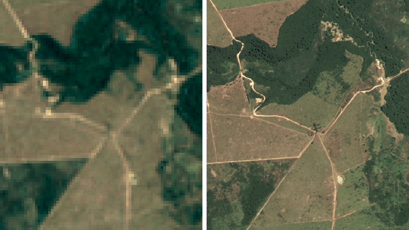
Image depicting previously available historical imagery for the 2008 baseline year (left) and showing the new, detailed imagery dataset created by Google (right).
Google has a long history in working to create helpful datasets for nature and biodiversity conservation, such as Dynamic World (our 10-meter land cover dataset), the Satellite Embedding dataset powered by AlphaEarth Foundations (our annual, analysis-ready collection of learned geospatial embeddings), and forest commodity datasets. With the Brazil Forest Imagery Dataset 2008, we are proud to focus our efforts on a dataset that makes critical Brazilian forest and landscape features in 2008 visible for the first time, helping our partners at MGI and MMA, and private landowners, make more informed decisions grounded in clearer and transparent data.
Building Foundational Data for Impact
To build this 2008 dataset, we used Google Earth Engine to process more than 6,000 high-resolution SPOT satellite scenes (2, 4, and 5) from the 2007–2009 time window (extending the window only when 2008 data was unavailable to ensure a cloud-free mosaic) extracted from the CNES historical archive. This involved filtering out cloudy or low quality pixels, balancing image colors using radiometric corrections to blend them into a visually consistent view of Brazil and automated geographic coregistration to improve precise geographic placement (find details in the methodology documentation). The result is two mosaics: a **Visual Basemap (optimized for visual interpretation and verification) and an [Analytic Basemap](https://developers.google.com/earth-engine/datasets/catalog/GOOGLE_BRAZIL_FOREST_2008_V1_ANALYTIC)** (ready for machine learning and analysis).
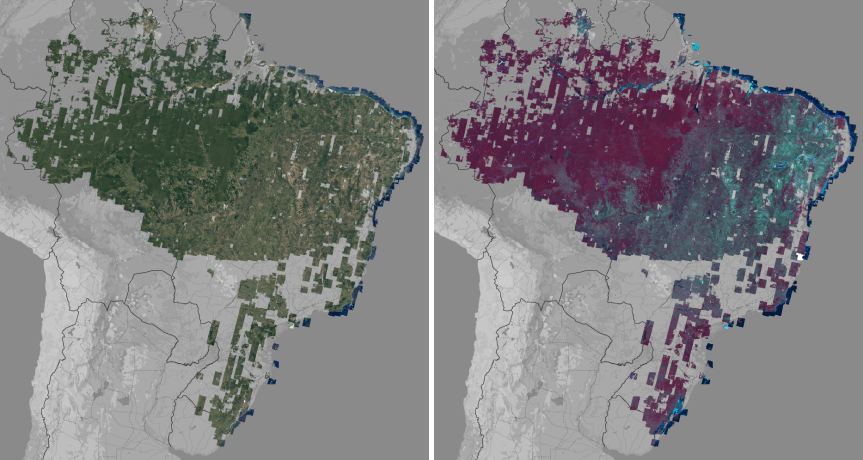
Full extent of the v1.0 Visual Basemap in pseudo-natural color (left) and the Analytic Basemap displayed as a near-infrared false-color (right). Images from Google Earth Engine
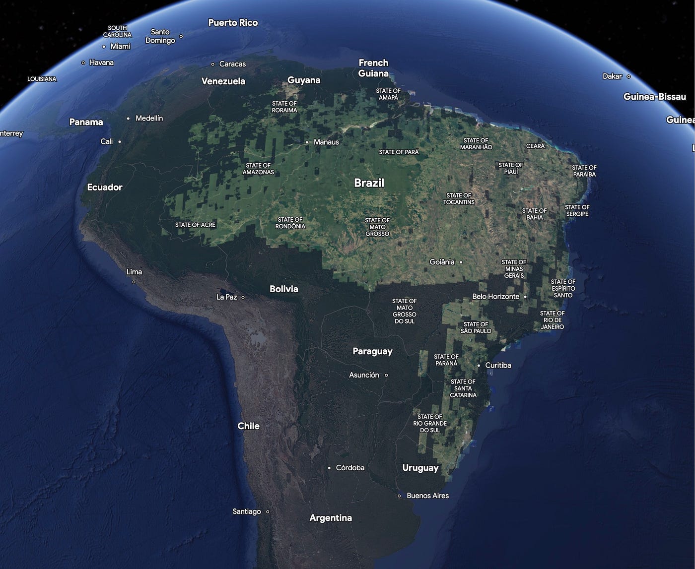
We prioritized near-complete, high-resolution coverage for privately-held CAR lands within states at the frontier of the Amazon with historically high rates of deforestation such as Maranhão, Mato Grosso, Pará, Rondônia, and Tocantins, as well as covering CAR properties in many other states. This targeted approach focuses on quality where the Forest Code’s implementation is most critical.
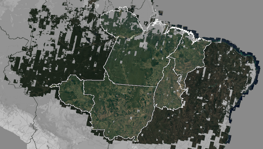
The v1.0 Visual Basemap coverage across Maranhão, Mato Grosso, Pará, Rondônia, and Tocantins. Image from Google Earth Engine
While raw SPOT satellite scenes are also available from Google as image collections, Google created the two Brazil Forest Imagery Dataset 2008 Basemaps to provide ready-to-use products that allow for immediate visualization and analysis within Google Earth and Earth Engine and applications such as SICAR (the Rural Environmental Registry System).
This data is designed to work in tandem with existing archives. While Landsat offers an invaluable 50-year record at 30 m resolution for identifying broad trends, our 2008 dataset provides the “zoom lens” needed to verify specific property boundaries (CAR) and determine exactly what existed on the ground during the baseline year for the Brazil Forest Code.
Unlocking Local Action
These basemaps provide a more detailed, accurate, actionable and transparent picture of the historical Brazilian landscape, enabling more-informed understanding and decision-making by farmers and environmental authorities. The improvement in clarity unlocks the ability to identify critical small-scale environmental features — like forest patches and riverbanks — essential for Brazil Forest Code enforcement but previously indistinguishable. This will enable the Brazilian government to streamline forest protection efforts and unlock new economic incentives for private landowners for conservation.
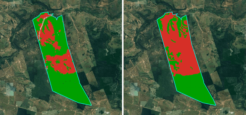
Image on left depicts a sample CAR assessment for a property done using previously available imagery. Image on right shows a more accurate sample CAR assessment resulting from the new, detailed imagery dataset. Image courtesy of Visiona
Through SICAR’s Public Consultation module, the imagery will be fully available and accessible to society, enhancing transparency and allowing for broad public oversight.
This is just the beginning of a partnership that will contribute to the future of environmental governance in Brazil. Throughout 2026, new steps in this partnership will allow this data to be used in automated CAR analyses, helping ensure better decisions, greater legal certainty, and stronger environmental compensation mechanisms such as Environmental Reserve Quotas, directing additional resources toward forest conservation.
By making this historical data widely available in Google Earth and Earth Engine, we hope to unlock the ability of both government, civil society and community members to make data-driven decisions that balance sustainable land use with forest conservation.
How to Get Started
To view the Visual Basemap, open the Google Earth Data Catalog and search for and select the “Brazil Forest Imagery Dataset 2008”. Then add the data layer to a project and explore.
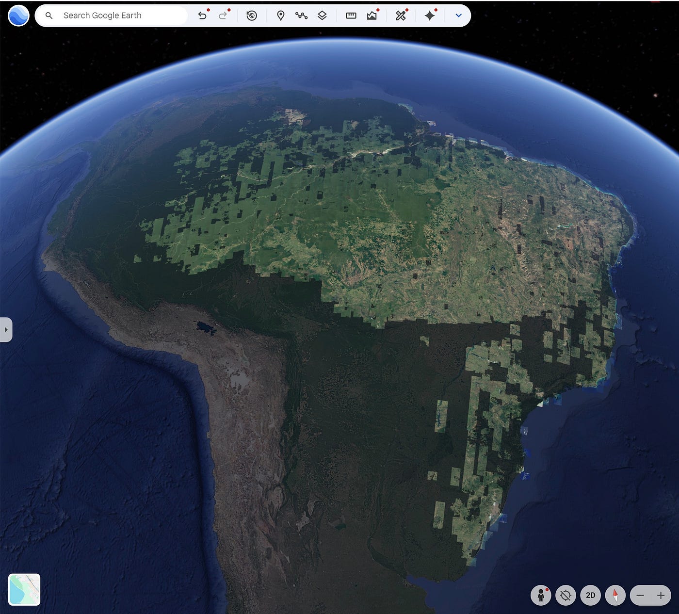
Find the Brazil Forest Imagery Dataset 2008 in the Google Earth Data Catalog to explore the dataset on the globe. Image from Google Earth.
If you are a developer or researcher who wants to use the data for analysis, the Brazil Forest Imagery Dataset 2008 is now live in the Earth Engine Data Catalog. Once you fill out the request form, you’ll be granted access to the datasets.
We look forward to seeing how the community uses this data to drive transparency and sustainability across Brazil. By providing a clear look at the past, we are helping build a more resilient future.
We’d like to acknowledge the contributions of Brazilian organizations MapBiomas and Imazon — known for combating deforestation through satellite and land use monitoring. Both organizations received access to preliminary versions of this data and contributed helpful feedback which guided Google’s production of this dataset.
메타데이터
- post_id
- c21b5fbbb5ee
- slug
- scaling-the-brazil-forest-code-a-high-resolution-baseline-for-2008-c21b5fbbb5ee
- url
- https://medium.com/google-earth/scaling-the-brazil-forest-code-a-high-resolution-baseline-for-2008-c21b5fbbb5ee
- canonical_url
- https://medium.com/google-earth/scaling-the-brazil-forest-code-a-high-resolution-baseline-for-2008-c21b5fbbb5ee
- author_url
- https://medium.com/@googleearth
- status
- ok
- fetched_at
- 2026-07-13 12:09:53