‘Crime Map II: Crime Harder’: A custom app for the Rutgers-New Brunswick community
‘Crime Map II: Crime Harder’: A custom app for the Rutgers-New Brunswick community
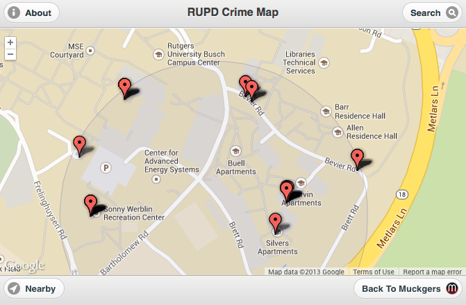
We’re pleased to unveil our new crime map app, a dynamic mobile webpage where you can set multiple options to see what/where crimes have occurred around the Rutgers-New Brunswick campuses.
The crime data is released as per the Clery Act, a federal law that requires all of this information to be public knowledge. It was named after Jeanne Clery, a student at Lehigh University who, in 1986, was brutally raped and murdered by a fellow classmate. Her parents then dedicated the rest of their lives to making sure college campuses would be safer places for students to live.
Before, we used batchgeo to help us plot crime incidents, but quickly ran into issues (you can read about those maps here). First, we were limited to about 200 map points per map, which was not optimal for the amount of data that we were working with. In order to get more (and to remove ads), we’d have to upgrade to their expensive subscription. Second, it only really worked on laptops and desktops, which was a huge limitation. And third, because of data limitations, we were forced to create individual maps by month, which was not a good thing if we wanted to get a general picture of a particular area over time. We chose to utilize a combination of Google Fusion tables, a Fusion API key, and a project developed by Code For America. We also did a little bit of custom coding of our own.
We will be updating the database every 2–4 weeks using the Rutgers University Police Department’s crime log data, which is then automatically displayed on the map.
There are many unique options you can choose to filter the data. First, the app asks for your current location. If you’re near or around New Brunswick, you will get a blue marker on the map. You can then go to the search functions and limit the scope of incidents to those that have occurred in a radius around where you are currently. You also can filter by the most common incident types, a rolling time period of incidents (1 month — default / 2 months / 3 months / 6 months), and case disposition.
While the app was designed for mobile platforms, it works very well on laptops and desktops.
RUPD releases the data on a day-to-day basis, so if you find that the number of markers on the map is getting light, it may be closer to the time where we need to collect it all again. This takes time, so bear with us (you may choose to see the previous two months worth of data instead). If you come across any errors or have any questions, feel free to drop us a line. Your feedback will help us to continue to improve this resource for the Rutgers and New Brunswick communities.
메타데이터
- post_id
- cd8a811a10f6
- slug
- crime-map-ii-crime-harder-a-custom-app-for-the-rutgers-new-brunswick-community-cd8a811a10f6
- url
- https://medium.com/muckgers/crime-map-ii-crime-harder-a-custom-app-for-the-rutgers-new-brunswick-community-cd8a811a10f6
- canonical_url
- https://medium.com/muckgers/crime-map-ii-crime-harder-a-custom-app-for-the-rutgers-new-brunswick-community-cd8a811a10f6
- author_url
- https://medium.com/@Muckgers
- status
- ok
- fetched_at
- 2026-07-24 13:42:39