Is the Piri Reis map related to the works of Eratosthenes?
A fragment of a map drawn on a gazelle skin was found on November 2, 1929, at the Topkapi Palace in Constantinople. While conducting an…
Is the Piri Reis map related to the works of Eratosthenes?
A fragment of a map drawn on a gazelle skin was found on November 2, 1929, at the Topkapi Palace in Constantinople. While conducting an inventory, Malil Edhem, the director of the Turkish National Museums, discovered two world maps in a navigation book titled Kitab-ı Bahriye.Written by Admiral Piri Ibn Haji Memmed (known as "Piri Reis"), the first of the two maps was created between March 9 and April 7, 1513, in his hometown of Gelibolu. The second map was established during the reign of Suleiman the Magnificent in 1528.
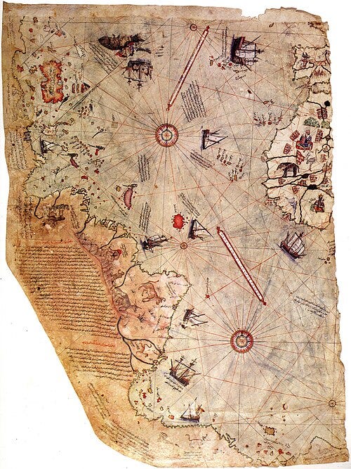
In the preface of the Kitab-ı Bahriye, the Admiral explains how he constructed the first map, relying on mathematical works and about twenty maps from various secret sources. He mentions figures such as Alexander the Great, Saint Brendan, Anton the Genoese, Nicola di Giuvan, Gabral, and Christopher Columbus. He describes obtaining a map from a Genoese infidel named Columbus after his uncle Kemal Reis captured a Genoese sailor who had traveled with the explorer. The sailor confessed that Columbus had his own work and map from Alexander the Great, revealing the existence of a continent west of the Western Sea with coasts, islands rich in metals and gemstones, and local tribes fond of glassware, explaining why Columbus carried so many glass pieces.
This map is initially surprising due to its graphic representation, as it includes many details that could not have been known during Piri Reis’s time. Longitudes are depicted, for instance, even though the concept did not exist then. The precision in drawing the eastern coasts of South America and the western coasts of Africa could be explained by its diverse origins. The Caribbean is detailed with annotations likely derived from Columbus’s gathered information. However, it’s perplexing that the map accurately describes the shores concealed by the ice of Antarctica and the islands comprising Greenland. Only in 1951 did Paul Eugène Victor discover that Greenland wasn’t formed by a single landmass. The question arises: who could have possessed knowledge and information collected dating back to before the last ice age, around the early Neolithic period, nearly 12,000 years ago?

Each region features a set of illustrations such as mountains, rivers, or animals that inhabit the area. The Andes, for instance, are depicted, revealing a drawing of an animal resembling a llama, described by the author as a "monster with white fur." The Amazon River is depicted twice, further indicating the compilation of data. Additionally, there are comments about populations and place names. At the top of the map, there is even evidence that one of Piri Reis’s sources is European, as an Irish legend is transcribed there.
The composition of the map is ultimately based on the principle of a radial projection, meaning a succession of concentric circles that allows locating elements in relation to each other. In this case, the point of origin for these circles was discovered in 1965 by Charles H. Hapgood’s team, who studied the map. It converges at Syene, present-day Aswan in Egypt. This is particularly intriguing because Syene is where the Greek scholar Eratosthenes, curator of the famous Library of Alexandria, calculated the Earth’s circumference in 200 BCE. By comparing the angle of sunlight on two similar objects, one in Alexandria and the other in Syene, during the summer solstice at solar noon, he deduced, based on the distance between the two cities, that the Earth had a circumference of 39,375 kilometers. This is close to the modern scientific value of 40,075.017 kilometers at the equator.Despite uncovering part of the map’s history, the origin of the oldest portolans remains unknown. Considering their significant value, they likely passed through the hands of the curator of the most illustrious ancient library the world has ever known.
메타데이터
- post_id
- ec3aa8d77b9b
- slug
- is-the-piri-reis-map-related-to-the-works-of-eratosthenes-ec3aa8d77b9b
- url
- https://medium.com/@osmont.gregory/is-the-piri-reis-map-related-to-the-works-of-eratosthenes-ec3aa8d77b9b
- canonical_url
- https://medium.com/@osmont.gregory/is-the-piri-reis-map-related-to-the-works-of-eratosthenes-ec3aa8d77b9b
- author_url
- https://medium.com/@osmont.gregory
- status
- ok
- fetched_at
- 2026-09-05 23:30:29