Exploring Vancouver’s Terrain: Analyzing Slope and Aspect Using GIS for Better Understanding of…
Introduction:
Exploring Vancouver’s Terrain: Analyzing Slope and Aspect Using GIS for Better Understanding of Topography
Introduction:
As a graduate student with a keen interest in geographic information systems (GIS), I recently embarked on a project that aimed to better understand the terrain of Vancouver, British Columbia. This project combined the powerful capabilities of QGIS to explore and visualize the city’s natural features, particularly focusing on two key elements: slope and aspect.
Vancouver’s landscape is characterized by its coastal mountains, rolling hills, and the surrounding waters of the Pacific Ocean, making it an excellent case study for topographic analysis. In this project, I utilized 3D GIS mapping to highlight areas with a slope less than 15 degrees and to analyze the aspect (direction the slope faces) with a particular focus on the eastern-facing slopes. This kind of analysis can reveal valuable insights into factors such as vegetation growth, sunlight exposure, and even potential areas for urban development.
Creating the 3D Maps: A Step-by-Step Process
Using QGIS, I processed elevation data for Vancouver to create 3D visualizations. Here’s an overview of the steps I followed:
- Slope Analysis: Using the Slope tool in QGIS, I calculated the slope of the terrain for the entire Vancouver area. This process converts elevation data into slope degrees, allowing me to visualize the steepness of the landscape. The result was a raster layer where each pixel represents the angle of the slope at that point.
- Highlighting Areas with Slope < 15°: To focus on relatively flat terrain, I filtered out areas where the slope was less than 15 degrees. This threshold is significant because it represents gently sloped land, which can be ideal for development or recreation. By using QGIS’s Raster Calculator, I isolated the areas with a slope below 15 degrees and visualized them in a 3D map.
- Aspect Analysis: The aspect of the terrain is essentially the compass direction that a slope faces. In Vancouver, the east-facing slopes are particularly interesting because they receive more direct sunlight in the morning, influencing vegetation, agriculture, and microclimates. I calculated the aspect using QGIS’s Aspect tool and focused on the eastern-facing slopes. This allowed me to see how the direction of slopes impacts the environment.
- 3D Visualization: After calculating the slope and aspect, I turned these layers into 3D maps in QGIS. The 3D views not only help visualize the elevation and directional aspects of the landscape but also make it easier to understand the terrain’s impact on human activity and natural processes.
Key Findings:
- Areas with Slope < 15°: The areas with a slope of less than 15 degrees are predominantly located in the lower-lying regions, near the city center and along the river valleys. These flatter areas are often suitable for urban development, agriculture, and recreation. The visual representation of these areas in 3D highlights their potential for expansion and how Vancouver’s growth could be directed toward these flatter regions.
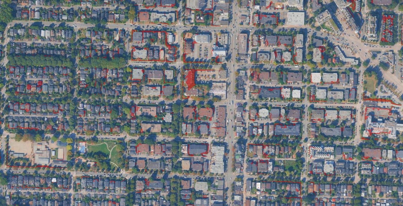
Some houses are on higher slopes
- East-Facing Slopes: By analyzing the east-facing slopes, I found that many of these areas lie on the lower half of Vancouver’s mountainous terrain, with a significant portion of them facing towards the morning sun. These eastward slopes are important because they receive early sunlight, which can affect everything from the timing of plant blooming to the temperature variation within these regions. This is particularly relevant for agriculture, where the orientation of slopes can dictate crop growth cycles.

East-Facing Slopes
- 3D Map Insights: The 3D maps bring these analyses to life. The changes in slope are easily identifiable, and the aspect map provides an intuitive way to understand the directional trends in the landscape. The use of 3D visualization makes it easier to grasp how Vancouver’s topography affects urban planning, energy efficiency in buildings, and the preservation of green spaces.
Why It Matters:
Understanding the slope and aspect of Vancouver’s terrain is essential for a variety of reasons:
- Urban Planning: Identifying flat areas for development can help city planners optimize land use while considering environmental constraints.
- Sustainable Development: Analyzing the aspect helps in choosing locations for solar energy installations, agriculture, and even residential areas that maximize natural resources.
- Environmental Management: The knowledge of slope and aspect can guide conservation efforts, particularly in preserving natural habitats and ensuring sustainable access to the outdoors.
Conclusion:
Through this project, I gained a deeper understanding of how GIS and 3D mapping tools can be used to analyze topographic features and provide valuable insights into urban planning, environmental management, and resource allocation. This exploration of Vancouver’s terrain using slope and aspect is just one example of how GIS can be applied to better understand our surroundings and make informed decisions.
As I continue my studies in GIS and municipal planning, I look forward to exploring more complex datasets and utilizing these skills to contribute to more sustainable, data-driven urban development strategies.
메타데이터
- post_id
- ec8385cf7e3f
- slug
- exploring-vancouvers-terrain-analyzing-slope-and-aspect-using-gis-for-better-understanding-of-ec8385cf7e3f
- url
- https://medium.com/@shawaiz.akhter0/exploring-vancouvers-terrain-analyzing-slope-and-aspect-using-gis-for-better-understanding-of-ec8385cf7e3f
- canonical_url
- https://medium.com/@shawaiz.akhter0/exploring-vancouvers-terrain-analyzing-slope-and-aspect-using-gis-for-better-understanding-of-ec8385cf7e3f
- author_url
- https://medium.com/@shawaiz.akhter0
- status
- ok
- fetched_at
- 2026-07-08 05:22:04