ASK-A-GEOLOGIST by Jeff Wynn
Deformation, GPS, and GNSS. Wait! Is that volcano… swelling? Part 3.
ASK-A-GEOLOGIST by Jeff Wynn
Deformation, GPS, and GNSS. Wait! Is that volcano… swelling? Part 3.
GPS is a fascinating field and applies all through and far beyond the earth sciences. A brief run-down might be useful here.
The Global Positioning System was first envisioned by DARPA — the Defense Advanced Research Projects Agency of the Department of Defense — during the 1980’s. Navigation at that time was complex and difficult, and getting any sort of location precision over vast distances including oceans was very important to some people. Korean Air flight 007 was shot down by a Russian Sukhoi-15 Interceptor near Sakhalin Island, Russia, in 1983 over what proved to be a small navigation error — two digits transposed by the Korean Airlines navigator.
It has long occurred to most nuclear-armed militaries that targeting their ballistic missiles would like to place them exactly, precisely on top of a hardened missile silo.
In the late 1980’s I was a young scientist working in the Venezuelan jungle, where our main form of navigation was to use 1:250,000-scale side-looking airborne radar (SLAR) maps. These were assembled by flight strips — radar images taken from high altitudes — and it was not unusual to find splice errors as large as 3 kilometers between strips. That means I could be standing on a single rock — and according to the SLAR map, half of the rock was 2 miles away from the other half of the rock. It gives the expression “huge strides” quite a different meaning.
I have been on a helicopter traveling for an hour over trackless forest using a half-meter-sized, million-scale roadmap of the Venezuela (except there are no roads in the jungle) and crudely penciled lines with the azimuth, and distance in flight-minutes to the target site that we wanted to visit. This was terrifying to me. If that helicopter’s fuel line had a single bug in it, we would have dropped down into the trees. Even assuming we had survived such a crash (the incident statistics gave me a 50% chance of surviving this sort of crash), how would you call in a rescue helicopter? How in the world would you even tell rescuers where you were, even if you had a working radio, when the wreck-site could not be seen beneath OR above the the jungle canopy?!? Your location and its accuracy thus become a life-and-death issue very quickly.
For me, as a Geoscientist working in remote ares, just knowing precisely where I was at all times was an over-riding life-saving task.
I first began using a GPS device in the early 1990’s in Saudi Arabia. In the northern reaches of the country there is a vast plain (the al-Jalamid Plain) that is dead flat for hundreds of kilometers in all directions. Some of our Saudi staff had accidentally strayed across the Iraqi border, because there is no way to know where the boundary line (arbitrarily drawn by the British almost a century earlier on a piece of map paper) actually was. The first GPS units were incredibly slow, the size of a Betty Crocker cookbook, and didn’t always work — but the idea fascinated me. With a radio, I could then tell people where I was within a hundred meters or so at that time; we could now find someone and perhaps save a life. This was a huge new safety margin for me, who once nearly bled out on a jungle floor in dire need of medical help.
Since then, hand-held GPS devices have shriveled to less than coin size (one on my wrist tracks my steps and bike-rides), and many have maps built in. You can program them with way-points, collect precise tracks of where you walked or flew… the list of bells and whistles goes on and on.
But how do they work? What is actually out (or up) there?
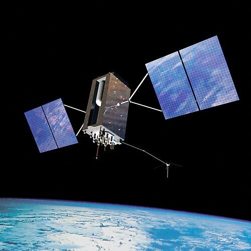
Artist’s impression of a GPS Block III satellite in orbit (Image: Wikimedia)
The American GPS constellation has at any given time about 24 active satellites and a few loitering backup spares. Each one transmits a very faint signal on two frequencies — a digital signal for hand-held device use, and another digital carrier (the “p-code”) that is used for more precision location acquisition. I’m talking about centimeter-size precision here. Both GPS frequencies were originally encrypted by the U.S. military. Because the satellites belonged to them, for a long time the signals were deliberately “fuzzed” — this was called Selective Availability, or SA for short. If you had the digital key and a certain type of book-sized device, you could get relatively precise locations — within 10’s of meters. But the U.S. Department of Defense didn’t want someone else using those same signals to pop an artillery round on top of an American military outpost in Afghanistan. Even to this day, if you try to use a receiver and go faster than a commercial airliner (as in: a ballistic missile) it won’t work. It’s a built-in fail-safe.
In the meantime, the rest of the world has become incredibly dependent on the American GPS constellation. Aircraft you fly in now use them to navigate — even use them to land in bad weather. I could never summarize adequately all the ways and places where GPS is used right now. As I write this, the Russians have their own satellite constellation called GLONASS, the European Union has one called GALILEO, the Chinese have the BeiDou Navigation Satellite System (BDS), and the Indians have the Indian Regional Navigation Satellite System (IRNSS) in orbit. In each case, these were launched to avoid dependence on the United States for anything that was mission-critical. Except creativity, perhaps.
If you are surveying — or trying to see if two points on the opposite sides of a volcano are moving apart from each other (uh-oh), then you need great precision. With modern GPS technology, this precision can now be better than a centimeter horizontally and 2–3 centimeters vertically. In part this difference in horizontal vs. vertical precision is because for horizontal solutions you can subtract the atmosphere effect from two different near-horizon satellites — and also triangulate better. For vertical elevations, you have only satellites in one direction (above you). You cannot detect a GPS signal from beneath your receiver because the signal would have to travel all the way through the Earth.
GPS signals all use closely-similar frequencies, but the signals are encoded differently to separate the satellites — the signal is digital. As implied earlier, signals from each satellite are encoded, so you can’t use one for a ballistic missile guidance system unless you own the codes.
The Russians (and Chinese) certainly didn’t want to be dependent on some signal that the Americans could fuzz — or even turn off. So, despite the crushing economic difficulties in Russia, they turned the best Russian minds onto building their own GPS constellation. The GLONASS signal is not encoded, and the energy transmitted is greater, so the signal-to-noise ratio is 5 times or 15 db better. Because of this, the signal penetrates tree canopy, so I could now use it in the trackless Venezuelan jungle where I used to work. The GLONASS system also uses 3 different frequencies, so you can reduce ambiguities and better calculate the complex differential atmospheric corrections. The GALILEO, BDS, and IRNSS systems are similar.
These five GNSS (Global Navigation Satellite Systems) are so precise that they even routinely calculate and correct for relativistic effects (called “frame dragging”)! We can thank Einstein for this. There are also huge atmosphere effects that must be compensated for — dense air masses here and differentially ionized layers there. GLONASS even works on new American and European hand-held devices when the American GPS signals are poor due to a restricted view of the satellite constellation — if you’ve ever been in the steep canyons in southern Utah or New York City, you know what I mean here. Not wanting to be left behind, the American version of GNSS (and the only one that should technically be called “GPS”) is being upgraded: a new generation GPS is here.
L1C is the newest civilian-use signal, broadcast on the same L1 frequency (1575.42 MHz) that contains the C/A signal used by all current GPS users. L1C broadcasting started in 2022 when the latest satellite generation, GPS III Control Segment (OCX) Block 1 became operational.
All five of these GNSS systems use L-band frequencies to resolve ambiguities and increase precision — and penetrate the ionosphere. What does L-band mean? Look at your personal car’s GPS antenna-fin, and the smallest dimension on it will give you an idea of a quarter-wavelength for L-band. That’s the size of your optimum-reception GPS antenna, by the way; this is just like looking at police car antennas to figure the frequency band being used in their radios.
The navigation problem is more than just triangulation. Three satellites near the horizon would serve for this; two would give you two possible location solutions, and three would reduce this to only one possible solution. But there are four unknowns in this complicated system since you must also measure how long the stretch of space and air that each signal must travel through — including clouds and weather systems. The precision of your timing thus becomes critical, because the speed of light is so huge (~300,000 km/second), and hand-held GNSS devices cannot carry $100,000 maser clocks. Thus, you must use a 4th satellite to help solve for the 4th unknown: 3 for position, and one more for a clock reference for your receiver. This is basic high-school matrix algebra that I learned as a sophomore.
There are a few more complications. Because of the 3D density variations of the Earth’s atmosphere, you can get even better precision if you also reference a ground station — there is at least one in every airport now. This will give you even better differential distance calculations — to do good back-corrections for the changing satellite orbits, the complex and varying atmosphere, rain, and snow cover, etc. However, during the Tohoku earthquake in early 2011, all of Japan jerked eastward about 10 centimeters/4 inches. Geodesists couldn’t see the whole shift with really great precision — because all their nearby reference stations also jerked eastward.
Back to volcanoes — the case in hand — how does GPS help volcanologists? As I wrote earlier, if two telemetered GNSS receivers are moving away from each other, and there is a volcano in between them (this has been happening for years now with Mauna Loa, the largest volcano on Earth), then you are being given a warning that something is moving into the volcano’s edifice — a fluid is filling in and increasing the rock volume in between the stations. Think: a balloon is filling.
In 1989 we didn’t have such a warning before Redoubt volcano in Cook Inlet of Alaska erupted. A KLM Boeing 747 flew right into the ash cloud — and lost all four engines in rapid succession. I’ve listened to a recording of the captain’s voice as she tried to guide her flight crew in Dutch and talk with flight control in Anchorage in English. Her voice rose steadily a full octave before she finally yelled “Anchorage we have lost all four engines. We are in a fall. We can use all the help you can offer.” They somehow managed to restart two of the engines and made a rough landing at Anchorage International airport. No lives were lost — but the repairs to make that single Boeing 747 flight-worthy again cost $80 million.
To put that in perspective, when I served as chief scientist for volcano hazards for the U.S. Geological Survey, my entire science team’s annual budget for predicting and mitigating volcano eruptions was less than $20 million. More perspective: there are over 1,600 volcanoes around the world.
There is another interesting GNSS application that you might find fascinating — I sure did. When Mount St Helens erupted on 1 October 2004, we had just a week of accelerating racket on our seismic network beforehand for a warning. The extrusion was first seen on October 12 — and by pure luck I got the first photo of the new pink “spine” from a helicopter orbiting the steaming and fractured Crater Glacier. This dacite (63% — 68% silica) extrusion was 700 degrees Celsius where it was coming up from the talus slope at its base. It came out like a tube of squeezed light gray/pink toothpaste. In fact, it resembled the back of a whale, so that became the name for one of several domes that would be extruded: The Whale.
The Whale moved south through crumbling talus and ice until it hit the remaining south rim wall of the 1980 eruption. The geodesists wondered when it actually reached that wall — “When Did the Whale Hit the Wall?” A check of a GPS station on the other side, on the outside south slope of the volcano, answered the question. On November 17, 2004, that station suddenly started moving southward. Was it an effect of snow on the antenna? No, because the only direction it moved was south — by about 10 cm.
The entire crater wall was shoved southward by about 4 inches by the growing dacite dome hitting it on the other side!
I’ll never forget the elation of scientists using GPS technology to answer this real world question about an erupting volcano. But GNSS systems provide us more than just answers to our scientific curiosity.
In 2005 a sharp-eyed geodesist then based in Anchorage, Alaska, was routinely checking data from several GPS units installed on Augustine volcano in the middle of Cook Inlet, south of Anchorage. This volcano had erupted in 1979 and nearly killed David Johnston, one of our brightest young geologists, who was then killed just a year later during the May 18, 1980, lateral blast, the opening eruption salvo of Mount St Helens.
In August 2005 our Anchorage-based geodesist noticed some differential movement between two GPS stations — the first subtle signal that inflation was starting — and notified the Alaska Volcano Observatory Scientist-in-Charge. A daily check-and-monitoring effort was started. Sure enough, the signal was real, showing above all the background noise — and it was continuing. Federal and State Emergency entities, along with the FAA (Federal Aviation Administration), were put on notice. In Late December the first Vt’s — rock-breaking seismic signals — started appearing on the seismometers. As they accelerated in frequency and amplitude, the USGS issued a warning: an eruption is imminent within hours or days. One day later, on January 16, 2006, Augustine erupted, and dusted Anchorage with ash. International flights were cancelled or re-routed for three days — but not a single aircraft was damaged this time, and not a single life was lost.
Yes!
This deformation stuff really works! And more to the point, it saves lives.
메타데이터
- post_id
- f7fa35cdc073
- slug
- ask-a-geologist-by-jeff-wynn-f7fa35cdc073
- url
- https://medium.com/@jeffwynnusgs/ask-a-geologist-by-jeff-wynn-f7fa35cdc073
- canonical_url
- https://medium.com/@jeffwynnusgs/ask-a-geologist-by-jeff-wynn-f7fa35cdc073
- author_url
- https://medium.com/@jeffwynnusgs
- status
- ok
- fetched_at
- 2026-07-27 21:01:28