Spatial Indexing in System Design: QuadTree, GeoHash, and H3 Explained
Introduction
Spatial Indexing in System Design: QuadTree, GeoHash, and H3 Explained
Introduction
Suppose you are designing:
- Uber
- DoorDash
- Google Maps
- Pokémon Go
- Nearby Friends
- Food Delivery
- Ride Matching
Sooner or later, a simple question appears:
“Find everything near this location.”
At small scale, you can scan all records and compute distances.
At Uber scale, with millions of drivers and riders continuously updating their locations, that approach becomes impossible.
This is where spatial indexing comes in.
Spatial indexes allow us to organize the Earth’s surface into manageable regions so that nearby searches, aggregations, and heatmaps can be performed efficiently.
In this article, we’ll compare three popular approaches:
- QuadTree
- GeoHash
- H3
and discuss when each one should be used.
Why Spatial Indexing?
Imagine storing every driver location as:
(driverId, latitude, longitude)When a rider requests a ride, we need to find:
Nearest 10 drivers within 3 kmWithout an index:
O(N)We must scan all drivers.
With a spatial index:
O(log N)or even better in practice.
Option 1: QuadTree
Core Idea
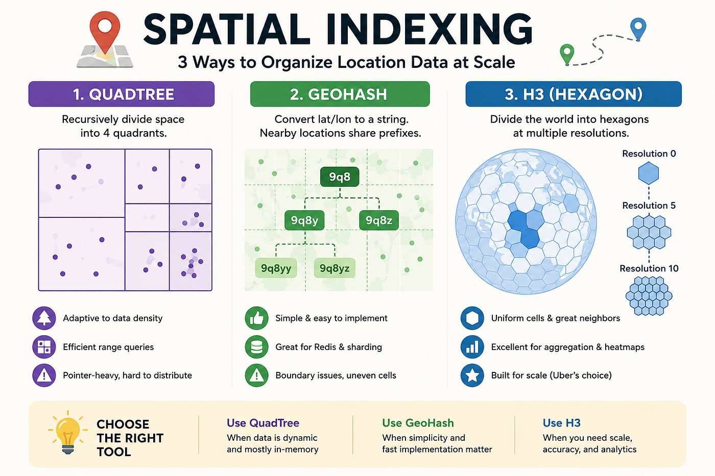
QuadTree recursively divides space into four quadrants.
           Root
        /  |  |  \
       NW NE SW SE
When a region becomes crowded, it splits into four smaller regions.
Large Cell
    ↓
Split
    ↓
4 Smaller Cells
Advantages
Efficient range queries
Adaptive to data density
Good for in-memory structures
Natural hierarchical organization
Problems
Pointer-heavy structure
Difficult to distribute
Hotspot regions become complex
Tree traversal overhead
Not friendly for Redis/Kafka partitioning
Typical Usage
QuadTree works well inside:
- Game engines
- GIS systems
- In-memory indexing
but is less common in modern distributed architectures.
Option 2: GeoHash
GeoHash takes a different approach.
Instead of building a tree structure, it converts latitude and longitude into a string.
Example:
9q8yyNearby locations often share the same prefix.
9q8
├── 9q8x
├── 9q8y
└── 9q8z
The longer the string:
Higher PrecisionWhy Engineers Love GeoHash
GeoHash is extremely simple.
You can directly use it as:
Redis Key
Database Index
Kafka Partition Key
Examples:
driver:9q8yy
restaurant:9q8yz
Prefix matching becomes location matching.
Advantages
Simple implementation
Easy Redis integration
Distributed-system friendly
Natural geo-sharding
Problems
Neighbor Problem
Two adjacent locations may belong to different prefixes.
A | BAlthough physically adjacent:
GeoHash(A) != GeoHash(B)A nearby search may need to query multiple prefixes.
Usually:
Current Cell
+ 8 Neighbor Cells
Uneven Cell Shapes
GeoHash cells are rectangular.
At different latitudes:
- Cell size changes
- Distances become distorted
Aggregation Is Awkward
Grouping by prefix works, but isn’t always clean.
Heatmaps and analytics become harder.
Option 3: H3
H3 was created by Uber.
Instead of rectangles, H3 divides Earth into hexagons.
Why Hexagons?
Hexagons provide:
- Uniform coverage
- Better neighbor relationships
- More balanced spatial representation
Every cell has:
H3 Indexsuch as:
8928308280fffffwhich uniquely identifies the cell.
Hierarchical Resolution
H3 supports multiple resolutions.
Resolution 0
    ↓
Resolution 1
    ↓
Resolution 2
    ↓
...
    ↓
Resolution 15
Each cell can be expanded or rolled up.
Fine-grained
    ↓
Aggregation
    ↓
Coarse-grained
Why Uber Likes H3
Neighbor Queries
Find nearby cells:
kRing(cell, k)No GeoHash boundary headache.
Aggregation
Perfect for:
- Heatmaps
- Driver density
- Demand forecasting
- Regional statistics
Example:
Orders per H3 Cellinstead of:
Orders per GeoHash PrefixDistributed Systems
H3 IDs are excellent keys.
Kafka Partition
Redis Key
Database Shard
Example:
h3:8928308280fffffHandling Data Skew
Popular cities:
- NYC
- San Francisco
- London
generate huge traffic.
H3’s hierarchical structure makes hotspot management easier than GeoHash.
Typical Uber Architecture
Driver GPS
      │
      ▼
Convert to H3
      │
      ▼
Kafka
      │
      ▼
Flink Streaming
      │
      ▼
Pre-Aggregation
      │
      ▼
Redis
Store multiple resolutions:
res=10
res=9
res=8
...
res=5
When users zoom out:
Read coarse cellsWhen users zoom in:
Read detailed cellsThis creates a smooth map experience.
QuadTree vs GeoHash vs H3

Which One Should You Choose?
Use QuadTree
When:
- Mostly in-memory
- GIS applications
- Dynamic spatial partitioning
Use GeoHash
When:
- Simplicity matters
- Redis indexing
- Geo-sharding
Use H3
When:
- Large-scale geo systems
- Heatmaps
- Aggregation
- Ride-sharing
- Food delivery
- Modern distributed architectures
Final Thoughts
Spatial indexing is one of those topics that quietly appears behind many large-scale systems.
GeoHash made geo-partitioning practical.
H3 pushed the idea further by introducing hierarchical hexagonal cells that support efficient neighbor queries, aggregation, and distributed processing.
If you’re preparing for system design interviews, understanding the trade-offs between QuadTree, GeoHash, and H3 is often more valuable than memorizing APIs, because these structures directly influence scalability, latency, and data distribution decisions.
메타데이터
- post_id
- 35f8fb354ff8
- slug
- spatial-indexing-in-system-design-quadtree-geohash-and-h3-explained-35f8fb354ff8
- url
- https://medium.com/@charleyjava/spatial-indexing-in-system-design-quadtree-geohash-and-h3-explained-35f8fb354ff8
- canonical_url
- https://medium.com/@charleyjava/spatial-indexing-in-system-design-quadtree-geohash-and-h3-explained-35f8fb354ff8
- author_url
- https://medium.com/@charleyjava
- status
- ok
- fetched_at
- 2026-06-21 21:05:38